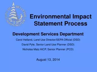
The Environmental Forecast Process
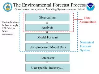
The Environmental Forecast Process. Observations , Analysis and Modeling Systems are now Linked. Observations. Data Assimilation. Has implications for how to apply CAL/VAL to future instruments. Analysis. Model Forecast. Numerical Forecast System. Post-processed Model Data. Forecaster.

The Environmental Forecast Process
E N D
Presentation Transcript
The Environmental Forecast Process Observations , Analysis and Modeling Systems are now Linked Observations Data Assimilation Has implications for how to apply CAL/VAL to future instruments Analysis Model Forecast Numerical Forecast System Post-processed Model Data Forecaster User (public, industry…)
Land • NCEP Land Data Assimilation System uses • Global precipitation fields from CPC Merged Analysis of Precipitation (CMAP) • uses SSM/I (passive microwave - scattering and emission) & high temporal resolution IR data from geostationary satellites • Daily NESDIS IMS 4km snow cover product • incorporates a wide variety of satellite imagery (AVHRR, GOES, SSMI, etc.) as well as derived mapped products (USAF Snow/Ice Analysis, AMSU, etc.) and surface observations. • Hourly 0.5 deg surface solar insolation from GOES • Fixed fields - AVHR-based 1km global vegetation type and monthly MODIS-based albedo (being tested) • Testing new products • Weekly global green vegetation fraction • GOES-based hourly 0.5 deg land surface temperatures • AMSR-E soil moisture
Ice • The NCEP sea ice analysis fields are produced from a passive microwave sensor (SSMI). • Emisivity over snow and ice is a critical issue Sept. 27, 2007
Observations NASA-NOAA-DOD JCSDA AMSR, GOES, AIRS, JASON, WindSat, MODIS Advanced ODA Techniques Ocean Satellite (AVHRR, JASON, QuikSCAT) In situ (ARGO, Buoys, Ships) Data Cutoff CFS: 2 week data cutoff RTOFS: 24 hour data cutoff OCEAN DATA ASSIMILATION OCEAN FORECAST CLIMATE FORECAST CFS-GODAS NCO/ODA EMC NOPP-JPL (ECCO) RT-OFS-GODAE NOPP EMC Shared history, coding, and data processing OPNL OCEAN FORECASTS Climate Forecast System Real-Time Ocean Forecast System HYCOM HOME MOM-3 MOM-4 HOME http://cfs.ncep.noaa.gov/ http://polar.ncep.noaa.gov/ofs/
NCEP Production Suite Weather, Ocean, Land & Climate Forecast Systems Current - 2007 Current (2007) GDAS NAM anal GFS anal GFS SREF HUR NAM GENS/NAEFS RDAS AQ RTOFS CFS
Forces for Change • Increasing emphasis on ensemble approaches • Multi-model ensembles • SREF • NAEFS • Climate Forecast System • Entering the NPOESS era • More rapid access to hyperspectral data • GPS soundings • Higher resolution surface radiance data • All models run within ESMF • Models run concurrently • Hybrid vertical coordinate • Coupled • Spanning all scales • Operational Earth System model – more explicit hydro, climate and ecosystems applications ESMF-based System Global/Regional Model Domain Model Region 1 Model Region 2
NCEP Production Suite Weather, Ocean, Land & Climate Forecast Systems Next Generation Prototype Phase 4 - 2015 Computing factor: 81 Rap Refresh Reforecast SREF WAV HUR NAM CFS MFS Global GENS/NAEFS GFS RTOFS RTOFS AQ Hydro / NIDIS/FF AQ CFS & MFS Regional RDAS Hydro GDAS