Download
1 / 27
280 likes | 585 Views
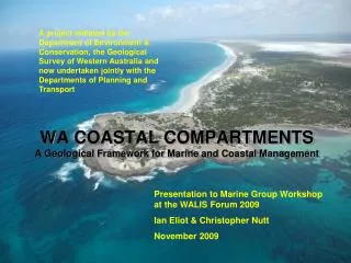
COASTAL COMPARTMENTS, SEDIMENT CELLS AND VULNERABILITY ASSESSMENT: A Progress Report. Presentation to WALIS MARINE GROUP MATT ELIOT AND IAN ELIOT Damara Pty Ltd, Innaloo , WA 19 July 2011. BASIC CONCEPTS

E N D
COASTAL COMPARTMENTS, SEDIMENT CELLS AND VULNERABILITY ASSESSMENT: A Progress Report Presentation to WALIS MARINE GROUP MATT ELIOT AND IAN ELIOT Damara Pty Ltd, Innaloo , WA 19 July 2011
BASIC CONCEPTS • The project develops a hierarchy of planning units, based on the geologic framework of the coast. • At the broadest planning levels the planning units comprise a set of discrete coastal compartments determined by geologic boundaries, structures, landforms and coastal aspect together with the landforms they contain. • At the most detailed planning levels the planning units are identified as sediment cells in which sediments sources, transport pathways and sinks can be clearly defined. • Together, coastal compartments and sediment cells provide a framework for a variety of applications including: • (a) planning and management of natural resources within the nearshore marine and coastal environment; and • (b) assessment of vulnerability to coastal hazards, climate change and rise in sea level.
Regions: Areas with recurring patterns of landform and geology suitable for regional mapping at scales of approximately 1:250,000 Zones: Broad sectors of the Australian continent based on climate Divisions: Provides an overview of the whole state suitable for maps at scales of about 1:5,000,000 Provinces: Areas defined on geomorphologic or geological criteria suitable for regional perspectives at scales of about 1:1,000,000 Land Systems: Areas of characteristic landform patterns suitable for mapping at regional scales of 1:50,000 to 1:100,000 Landforms: A local unit based on one or more landforms suitable for mapping at scales of about 1:5,000 to 1:15,000 Compartments: A local unit based on one or more definite landforms suitable for mapping at scales of about 1:25,000 to 1:50,000 Sediment Cells: A local unit based on several linked landforms suitable for mapping at scales of about 1:5,000 to 1:25,000
POTENTIAL APPLICATIONS COMPARTMENTS Landforms (Framework) & Processes (Drivers) PLANNING PURPOSES Marine & coastal risk assessment Marine & coastal planning Habitat description Marine conservation EBFM
Major Landform Assemblages • (After: Searle & Semeniuk 1985) • Nearshore Morphology • Islands • Linear reefs and submarine ridges • Pavements • Sand banks • Sand flats and seagrass meadows • Landforms of the Shore • Shoreline shapes (straight, irregular, arcuate and zeta-form) • Rocky coasts (cliffs, ramps and platforms) • Beaches (sheltered and exposed forms) • Onshore Landforms • Limestone plateaux and outcrops • Foredunes • Frontal dunes (blowouts and parabolic dunes) • Barriers • Estuaries • Deltas • Coastal lagoons and wetlands
An extreme event or events may change the type or location of a land system. eg. Avulsion (channel switching) and delta shift STABILITY SUSCEPTIBILITY VULNERABILITY Likelihood of erosional change to landforms related to current land surface condition Likelihood of structural breakdown leading to a change in the land system Likelihood of landform and/or land system change = + Gradual landform change associated with land surface instability ultimately results in structural change. eg. Barrier evolution
SUSCEPTIBILITY Long-term Structural Change STABILITY Short-term Landform Change Spit Mouth Ashburton River Delta 1963 Open river mouth Active spit Climbing dunes Perched barrier and climbing dunes Mouth Ashburton River Delta 2009 Open river mouth Active chenier Cliff & talus slope No barrier. Perched beach and old dunes
Rank 1: High cliff (>10m) plunging to subtidal level Rank 2: Moderate to high cliff (>10m) with an intertidal platform Rank 3: Cliff (5 - 10m high) and wide intertidal platform The susceptibility of rocky coast refers to the intrinsic propensity of a coastal land system or landform structure to alter in response to projected change in metocean conditions over a long period, commonly extending to millennia. Variation in structure may occur spatially, due to differences in rock type; or temporally as a result in the differences in the strength of the same rock type and exposure to disparate processes. Rank 4: Rock pavement or intertidal platform and low bluff (<5m high) Rank 5: Gently sloping rocky shore ROCKY COAST SUSCEPTIBILITY The sequence illustrated here loosely follows that described by Sunamara (1992).
Rank 1: Episodic Transgressive Barrier Nested blowouts and parabolic dunes. Rank 3: Stationary Barrier Low or narrow ridge of blowout Rank 2: Prograded Barrier Low, foredune ridge plain The susceptibility of a sandy barrier refers to the intrinsic propensity of the structure comprising the barrier system to alter in response to projected change in metocean conditions, particularly sea level rise over. Barrier formation occurs over a long period, commonly millennia, although structural change from one type to another may occur within tens to hundreds of years. Rank 4: Receded Barrier Low narrow dune ridge & old shoreline Rank 5: Mainland Beach Narrow duns & beach abutting bedrock. SANDY (BARRIER) COAST SUSCEPTIBILITY The sequence illustrated here follows that described by Roy (1994).
Rank 3: Perched beach adjoining a low bluff Rank 1: No beach OR a foredune is located on a high rock platform (>HAT) Rank 2: Perched beach is located on a supratidal rock platform Estimates of beach instability are based on the exposure of the beach to metocean processes. The variability of sandy beaches in different settings has been described by Nordstrom (1992) and Short (2005). The stability of sandy beaches perched on rocky substrates is not as well known, although such beaches are common features of the Australian coast. The sequence shows beaches subject to increasing exposure to wave and sea level variation. Rank 4: Perched beach on an intertidal platform or beachrock ramp Rank 5: Perched beach on shallow inshore pavement STABILITY ON MIXED SANDY AND ROCKY COAST The sequence illustrated here follows that described by da Silva (2010).
Rank 1: Undisturbed dune sequence OR Fully vegetated (>75% cover on barrier). Rank 2: 50 to 75% vegetation cover on barrier OR <25% active dunes or bare sand Rank 3: 25-50% vegetation cover on barrier OR 25-50% mobile dune Estimates of instability are based on the land surface condition and the proportion of area in a compartment or cell that is currently bare sand or subject to erosion. Destabilisation of dunes occurs with destruction of a foredune, scarping of the frontal dunes or removal of the vegetation cover. Changes to vegetation cover take place in a short period, commonly sub-decadally. Rank 5: Mobile sand sheets OR <25% vegetation cover on barrier. Rank 4: <50% vegetation cover on barrier OR 50-75% active dunes or bare sand STABILITY ON SANDY COAST The sequence illustrated here follows that described by Short (1988).
Land system and landform description and Ranking for susceptibility and instability
INDICATIVE VULNERABILITY MATRIX MIXED SANDY AND ROCKY COAST
VULNERABILITY ESTIMATES COMPARTMENTS AND CELLS
INDICATIVE VULNERABILITY MATRIX BASED ON LARGE LAND SYSTEMS VULNERABILITY = SUSCEPTIBILITY + INSTABILITY
VULNERABILITY ESTIMATES PRIMARY COMPARTMENTS
POTENTIAL APPLICATIONS COMPARTMENTS Landforms (Framework) & Processes (Drivers) PLANNING PURPOSES Marine & coastal risk assessment Marine & coastal planning Habitat description Marine conservation EBFM
START DETERMINE THE SCOPE 0F PROJECTED CHANGE & RESPONSE URGENCY Community Involvement through information gathering and workshops Determine gaps in available information and assess further needs Community Involvement through information exchange and workshops Monitor and assess actions implemented under the strategy Improve understanding of the biophysical environment Implement strategy based on current available information ISO 31000 Methodology applied to NCCOE (2004) vulnerability assessment Acquisition of new information and data as the cycle is repeated Determine a strategy for hazard management and risk avoidance Agree on environmental, social and economic values for risk mitigation (1) Initial strategy is based on available information. (2) Review strategy at 5 year intervals Identify areas requiring new work or replacement of infrastructure Estimate current environmental, social and economic costs Identify projected hazards and risks to people & property Community Involvement through information exchange and workshops PLANNING CYCLE FOR COASTAL RISK ASSESSMENT Project in cycle Community participation Planning for hazard & risk mitigation © Ian Eliot 2009
AS NZS (2009) ISO 31000 Risk Assessment Framework Adapted to Coastal Management From: Rollason et al. (2010) and Rollason & Haines (2011)
Commonwealth Climate Change Assessments Cities Project NCVA LAPP ANUGA PNP State Government Coastal Assessments Coastal Process Studies Coastal Hazard Assessments Coastal Planning Studies SPP2.6 Review Pilbara Cities Regional Strategies Local Government Coastal Assessments DIVERSE!!