Download
1 / 23
260 likes | 620 Views
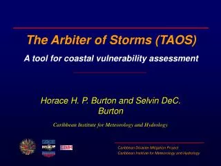
The Arbiter of Storms (TAOS) A tool for coastal vulnerability assessment. Horace H. P. Burton and Selvin DeC. Burton Caribbean Institute for Meteorology and Hydrology. Storm surge definition. The increase in water levels resulting from the passage of a tropical cyclone

E N D
The Arbiter of Storms (TAOS)A tool for coastal vulnerability assessment Horace H. P. Burton and Selvin DeC. Burton Caribbean Institute for Meteorology and Hydrology
Storm surge definition The increase in water levels resulting from the passage of a tropical cyclone Surge is an oceanic event responding to meteorological and other driving forces
Surge Components • Height depends on complex interaction of several factors including: • wind field • pressure anomaly • size and speed of motion of the system • bottom topography near the storm's landfall point • astronomical tides • maximum wind speed, which is closely related to the minimum sea-level pressure, is the most important factor
Still Water Level at Shoreline Wave Runup Wave Crest (Total Water Level) Wave Setup Wind Setup Pressure Setup Mean Low Water Astronomical Tide Shoreline at Mean Low Tide Storm Surge Hazard Components
Surge components • Pressure setup - increase in water level due to the lower atmospheric pressure in the interior of a storm • Wind setup - increase in water level due to the force of the wind on the water. • Wave setup - increase in still water levels resulting from mass transport by breaking waves • Astronomical tides - increase due to lunar and solar tides. This effects is typically small in the Caribbean.
Surge components • Wave runup- area where the inertia of breaking waves carries water up a beach • Still water level at shoreline- highest water level at a point on the shoreline, if wave action is smoothed out • Storm surge heights vary from as little as 1 m or less to 5 m or more depending on factors contributing to the surge
The Arbiter of Storms (TAOS) A PC-based storm hazard model for assessing storm surge and wind hazards from tropical storms Developed by Charles Watson Licensed to OAS
CIMH and TAOS model • CIMH isinstitutional home for TAOS/L in region • First version of TAOS/L installed at CIMH in December 1994 • Experience with model has led to enhancement and changes to model • Latest version of model installed in July 1999
Model description • Input data • Terrain - derived from a number of sources including satellite data • Storm track or wind field data • location, maximum wind, minimum pressure, eye diameter • Surface characteristics • Frictional values for land and water
Model description • Three processing modules which are coupled • Wind / atmosphere • computes wind at 5 metres above surface • Water flow • computes storm surge heights • Wave • generates wave heights in deep water
Model description • Output data • Storm surge heights • Maximum wind field • Time series for surge, wind and wave at selected locations • Maximum Envelopes of Water/Wind (MEOWs)
1 m contour 60 m/s contour TAOS/L Output - Luis 1995 Wind Speed Storm Surge Antigua
TAOS/L Output - Luis 1995 Wind Speed Storm Surge
TAOS/L Output - Luis 1995 Wave Heights
MEOWs • Maximum water level (or wind speed) for a storm of a chosen intensity, forward speed and track • Produced by running the model for multiple storm tracks, spaced a fixed distance apart, for a selected intensity, speed and direction • Results of runs are combined into a single map showing, for each point on the map, the maximum value generated across all the model runs.
Model validation • TAOS results generally consistent with those of SLOSH and French model • TAOS model estimates generally within 0.3 m of observations 80% of time and less than 0.6 m of observations 90% of time
Estimated Storm Surge (ft) Luis 1995 Model validation - Luis 1995
Errors: (metres) Maximum 0.77 Average 0.19 Median 0.13 Model validation - Marilyn 1995
Advantages of TAOS/L Model • Integrates wind, wave and storm surge hazards • Bathymetric and topographic data easily updated • Small run times allowing for use in real time • Simple input data taken from NHC advisories • GIS-compatible results
Application of output • Emergency managers • Identify high risk areas for storm surge and prepare evacuation plans • Physical planners • Locating safe housing and urban expansion areas
Application of output • Builders and home owners • Retrofitting existing structures to acceptable levels of risk or to build new structures to appropriate design standards • Insurance industry • Accurately estimate the risk for a property and set rates that differentiate by risk level