Winter Weather Spotter Course
330 likes | 516 Views
Winter Weather Spotter Course. National Weather Service Northern Indiana. Course Outline. Introduction to NWS Winter Weather Advisories/Watches/Warnings Snow Spotters – our network today Reporting real time information – what do we need to know about? What to report after the storm is over

Winter Weather Spotter Course
E N D
Presentation Transcript
Winter Weather Spotter Course National Weather Service Northern Indiana
Course Outline • Introduction to NWS Winter Weather Advisories/Watches/Warnings • Snow Spotters – our network today • Reporting real time information – what do we need to know about? • What to report after the storm is over • How to measure snow • How to report your information
Definitions • Freezing Rain – Rain falls as liquid and then freezes on contact • Sleet– Rain drops freeze into ice pellets priorto reaching ground. • Snow – An aggregation of many ice crystals • Graupel – Snowflakes which have been heavily rimed. Also called snow pellets, soft hail, and hominy snow. Looks like uncooked white grits.
Definitions (cont.) • Snowfall – Amount of new snow which has fallen. Measured to the nearest tenth of an inch. • Snow Depth – Total amount of snow on the ground (old and new). Measured to the nearest inch.
Watches/Warnings/Advisories • Hazardous Weather Outlook • Winter Storm Watch • Winter Storm Warning • Lake Effect Snow Warning • Blizzard Warning • Winter Weather Advisory
Hazardous Weather Outlook • Issued each day between 5am and 6am • Outlines potential weather hazards expected over the next 7 days • The potential for major storms beyond 2 days will be discussed in the HWO
Winter Storm Watch • Typically issued 24 to 36 hours in advance of the storm • Issued when potential exists for: • 6inches or more of snow in 12 hours • 8inches or more of snow in 24 hours • Significant mixed precipitation
Winter Storm Warning • Typically issued 6 to 12 hours in advance of the storm • Issued when the following are likely: • 6 inches or more of snow in 12 hours • 8 inches or more of snow in 24 hours • 0.25 inches or more of freezing rain
Lake Effect Snow Warning • Same criteria as a Winter Storm Warning • 6 inches in 12 hours • 8 inches in 24 hours • Lake effect snow warning implies the localized nature of the heavy snow – in most cases not everyone in a county will receive warning criteria snowfall
Blizzard Warning • Wind speeds of 35 mph or greater AND • Visibility of ¼ mile or less in blowing snow • Conditions must persist for at least 3 hours • Blizzards may or may not be accompanied by falling snow (Ground Blizzard)
Winter Weather Advisory • Typically issued 6 to 12 hours in advance of storm • Issued when the following are likely: • 4 to 5 inches of snow in 12 hours • Light accumulation of freezing rain (less than 0.25 inches)
Where We are Today Existing Snow Spotter Network At NWS Northern Indiana
Need for More Spotters • Existing COOP network is evenly spread over our County Warning Area (CWA) • We need to fill in the gaps between COOP and official NWS observing sites – as you well know, snowfall can vary widely within the same county, especially in areas which receive lake effect snow • This is where YOU come in!
Reporting Real time Information What type of Information can be useful to us?
Real Time Information • Heavy Snow – for example, snow falling at the rate of 1 inch per hour • Precipitation type change – snow to rain, rain to snow, freezing rain, etc. • Is the precipitation causing problems on roads? • Significant Blowing and Drifting Snow – Is drifting making travel difficult (or impossible)?
Freezing Rain • Is there a glaze accumulation on roads and sidewalks or only on elevated surfaces, such as trees and power lines? • How much ice has accumulated on surfaces. This can be difficult to measure directly, but can be easily estimated. • Measuring trick – Crack a piece of ice off a railing and measure the thickness.
When the Snow Lets Up • Get a final measurement. • Report your total snowfall for the event, and how long it was snowing. • For example: 7 inches in 10 hours. • In the case of freezing rain, also report the total amount of glaze on surfaces.
What Do We Use Your Reports For? • Update forecasts, warnings, and advisories to better match conditions being reported • Our updated forecasts and warnings in turn allow local officials to make better decisions • We use storm total snowfall and ice accumulation data to verify forecasts and warnings
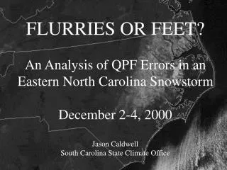
How to Measure Snow Yes, that says 54 inches!
Before the Snow Flies • Place a snowboard outside. Choose a location away from trees, shadows, and known drifting areas. • A snowboard can be any light colored board, about 2 feet by 2 feet. A piece of plywood painted white works great! • Mark the snowboard location with a stake so you can find it easily in the snow.
Measuring the Snow • If it is windy, it can be more accurate to take several measurements on the board and take an average. • After you measure, sweep the snow board clean. • You can clean the snow board off up to 4 times in 24 hours, but no more than once in 6 hours.
Special Cases • If snow falls and accumulates, then melts, the total snowfall will be the maximum measured before the snow melts • If snow falls and melts on contact, never reaching 0.1 inch depth, a trace of snow is recorded. • Sleet counts towards the snowfall total, but freezing rain does not.