Download
1 / 7
70 likes | 187 Views
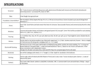
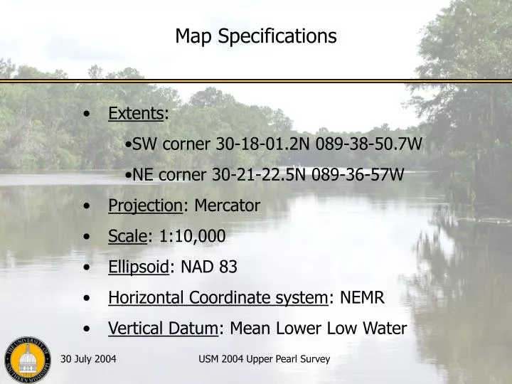
Map Specifications. Extents : SW corner 30-18-01.2N 089-38-50.7W NE corner 30-21-22.5N 089-36-57W Projection : Mercator Scale : 1:10,000 Ellipsoid : NAD 83 Horizontal Coordinate system : NEMR Vertical Datum : Mean Lower Low Water. Field Chart Production.

E N D
Map Specifications • Extents: • SW corner 30-18-01.2N 089-38-50.7W • NE corner 30-21-22.5N 089-36-57W • Projection: Mercator • Scale: 1:10,000 • Ellipsoid: NAD 83 • Horizontal Coordinate system: NEMR • Vertical Datum: Mean Lower Low Water USM 2004 Upper Pearl Survey
Field Chart Production Text (river, land areas and major roads) USM 2004 Upper Pearl Survey
Layers and Group Codes USM 2004 Upper Pearl Survey
Products:ENC Debbie Mabey
Preparation Activities:Tides and Leveling Jennifer Wozencraft
Products:HPD Rafael Ponce
Products:ROS Todd Barnhill