Download
1 / 43
430 likes | 571 Views
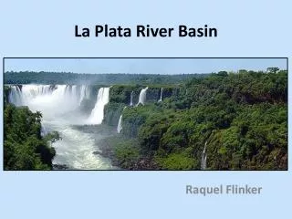
University of Washington hydrological modeling in La Plata basin. Dennis P. Lettenmaier Department of Civil and Environmental Engineering University of Washington IAI Project Meeting The Impact of Land Cover and Land Use Changes on the Hydroclimate of the La Plata Basin San Luis, Argentina

E N D
University of Washington hydrological modeling in La Plata basin Dennis P. Lettenmaier Department of Civil and Environmental Engineering University of Washington IAI Project Meeting The Impact of Land Cover and Land Use Changes on the Hydroclimate of the La Plata Basin San Luis, Argentina April 29, 2009
Related publications Su, F., Y. Hong, W.L. Crosson, H. Gao, and D.P. Lettenmaier, 2010, Potential utility of the real-time TMPA-RT precipitation estimates in streamflow prediction, to be submitted, J. Geophys. Res. Su, F. and D. P. Lettenmaier, 2009: Estimation of surface water budget of La Plata Basin, J. Hydrometeorology 10(4), 981-998. Saurral, R.I., V.R. Barros, and D.P. Lettenmaier, 2008: Land use impact on the Uruguay River discharge, Geophys. Res. Lett., 35, L12401, doi:10.1029/2008GL033707. Su, F., H. Yang, and D.P. Lettenmaier, 2008: Evaluation of TRMM Multi-satellite Precipitation Analysis (TMPA) and its utility in hydrologic prediction in La Plata Basin , J. Hydrometeorology, 9(4), 622-640.
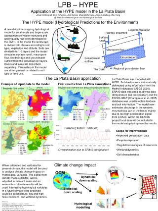
Data sources • Meteorological forcings Daily time series of precipitation, maximum temperature, minimum temperature, and wind speed Daily precipitation and temperature are from NCAR and GDCN (Global Daily Climatology Network) station data. wind speed is downscaled from the NCEP/NCAR reanalysis • Land surface characteristics Soil parameters: from Global Soil Data Products CD-ROM (IGBP-DIS) Land cover characterization: based on University of Maryland 1-km global vegetation classifications.
Parana Paraguay Uruguay Lower Basin • Precipitation stations for 1986 (2050) • Poor coverage areas: Paraguay basin and Lower basin of the Parana River.
Temperature stations for 1986 (125). • Stations are sparse for the whole basin. Paraguay Parana Uruguay Lower Basin
VASClimO (Variability Analysis of Surface Climate Observations) gridded monthly half-degree precipitation. Mean monthly precipitation (this study) 1979-1999
Paraguay Parana Uruguay Uruguay Parana Paraguay
Modeling the water budget of LPB Selected results from Su et al (J Hydromet, 2009)
Streamflow simulations • Study area: the whole La Plata Basin • Model options: with full energy balance • Model resolution: 1/8 degree • Time step: 3-hour
Model description • Model features: • multiple vegetation classes in each cell; • energy and water budget closure at each time step; • subgrid infiltration and runoff variability; • and non-linear baseflow generation.
FIG. 7. Spatial fields of annual mean precipitation (mm/yr) from this study (a), CRU (b), VasclimO (c), and ERA-40 reanalysis (d) for La Plata Basin (1979-1999).
Mean Monthly Streamflow (1979-1999) Paraguay Parana Parana at Jupia Area:478,000km2 Paraguay at Bermejo Area: 1,100,000km2 Paraguay Parana Uruguay Iguazu at EstreitoArea:63,236km2 Parana at Posadas Area:975,000km2 Uruguay at Paso de los Area:189,300km2 Simulated Observed
FIG. 8. Spatial fields of annual mean evaporation (mm) from the VIC model (a), ERA-40 reanalysis (b), and atmospheric water budget estimates (c) for La Plata Basin (1979–1999).
FIG. 9. Spatial fields of annual mean runoff (mm) from the VIC model (a), ERA-40 reanalysis (b), and atmospheric moisture convergence P-E (c) for La Plata Basin (1979–1999).
FIG. 10. Seasonal variability of water budget components over the Uruguay, Upper Paraná, Paraguay, and the entire La Plata basin for the period 1979-1999: P precipitation (a), E evaporation (b), R runoff (c), and P-E (d) from observations, the VIC model and ERA-40 reanalysis, and atmospheric moisture convergence.
FIG. 10. Seasonal variability of water budget components over the Uruguay, Upper Paraná, Paraguay, and the entire La Plata basin for the period 1979-1999: P precipitation (a), E evaporation (b), R runoff (c), and P-E (d) from observations, the VIC model and ERA-40 reanalysis, and atmospheric moisture convergence.
Vegetation and climate change effects on streamflow in the Uruguay River basin (from Saurral et al, 2008)
1990s land cover (U MD) Global Potential Vegetation (Ramankutty and Foley) Forest/Woodland Shrubland/grassland Cropland Uruguay River basin land cover change – potential vegetation vs 1990s
Simulated and observed streamflows, Uruguay River at Concordia, Uruguay – calibration (1995-99) and verification (1990-94). Visual courtesy Ramiro Saurral and Vicente Barros, University of Buenos Aires
Simulated and observed mean monthly flows at Concordia, 1990-99 for ~1990 land cover, and sensitivity to land cover change (forest type 7; grassland type 10) Visual courtesy Vicente Barros and Ramiro Saurral, University of Buenos Aires
Predicted and observed Concordia discharge, decade of 1960s (upper) and 1990s (lower), both simulations using 1990s vegetation, and consistent observing network for two decades. Visual courtesy Vicente Barros and Ramiro Saurral, University of Buenos Aires
Evaluation of TRMM satellite precipitation product in hydrologic simulations of La Plata Basin Fengge Su1, Yang Hong2, and Dennis P. Lettenmaier1 AGU Fall Meeting December, 2006 1University of Washington, Seattle, WA 2 NASA Goddard Space Flight Center, Greenbelt, MD
Data sets and methodology • The TRMM product evaluated in this study is the TRMM Multi-satellite Precipitation Analysis (TMPA) research product Version 6 3B42. • It combines precipitation estimates from multiple satellites, as well as gauge analyses, where available, at a 3-hour time step and 0.25° degree spatial resolution. • The data set covers the latitude band 50°N-S for the period 1998 to the delayed present. Huffman et al., 2006, The TRMM Multi-satellite Precipitation Analysis (TMPA): Quasi-Global, Multi-Year, Combined-Sensor Precipitation Estimates at Fine Scales (to appear in Journal of Hydrometeorology)
Methodology • Basin average precipitation estimates from the TRMM Satellite precipitation product (Version 6 3B42) and gauges are compared with each other at both daily and monthly time scales. • The Variable Infiltration Capacity (VIC) land surface hydrology model is forced by daily 3B42 and gauged precipitation over several subbasions of La Plata. The simulated streamflow is compared with each other and with available observed streamflow.
3. Precipitation evaluation Rrmse=60% Rrmse=13% Rrmse=134% Rrmse=15% Rrmse=44% Scattergramsof daily basin-averaged precipitation estimated from gauged and TRMM data.
Monthly Basin-averaged Precipitation Scattergrams of monthly basin-averaged precipitation estimated from gauged and TRMM data.
4. Hydrological Modelling • Model features: • multiple vegetation classes in each cell; • energy and water budget closure at each time step; • subgrid infiltration and runoff variability; • and non-linear baseflow generation. The VIC (Liang et al, 1994;1996) model is a grid-based land surface scheme designed both for inclusion in GCMs, and for use as a stand-alone macro-scale hydrological model.
Observed Simulated with TRMM Prce. Simulated with gauged Prce. Daily streamflow for basin 3802 3802, Uruguay at Paso de Los Libres (Area: 189, 300 km2) m3/s m3/sm3/s Green VS. Black: Ef = 0.85, Er = 2% 1998 1999 Red VS. Black: Ef = 0.48, Er = 12% 1998 1999 Red VS. Green: Ef = 0.54, Er = 16% Nash-Sutcliffe efficiency (Ef) Relative error (Er) 1998 1999
Observed Simulated with TRMM Prce. Simulated with gauged Prce. Daily streamflow for basin 6301, 6598, and 6682 (a) 6301, Parana at Jupia (Area: 478,000km2) m3/s m3/sm3/s Red VS. Green: Ef = 0.73, Er = 4% 1998 1999 (b) 6598, Iguazu at Estreito (Area: 63,236 km2) Red VS. Green: Ef = 0.73, Er = -1% 1998 1999 (c) 6682, Paraguay at Ladario (Area: 459,990 km2) Red VS. Green: Ef = 0.72, Er = 18% Nash-Sutcliffe efficiency (Ef) Relative error (Er) 1998 1999
Observed Simulated with TRMM Prce. Simulated with gauged Prce. Monthly streamflow for the four subbasins m3/s m3/s m3/sm3/s (a) 3802, Uruguay at Paso de Los Libres (b) 6301, Parana at Jupia (c) 6598, Iguazu at Estreito (d) 6682, Paraguay at Ladario 1998 1999
Hydrological evaluation of satellite precipitation products in La Plata basin 1Fengge Su, 2Yang Hong, 3William L. Crosson, and 4Dennis P. Lettenmaier AGU Fall Meeting December, 2007 1,3USRA at NSSTC/NASA/MSFC, Huntsville, AL 2University of Oklahoma, Norman, OK 4University of Washington, Seattle, WA
Satellite-based precipitation: (1) The TRMM Multi-satellite Precipitation Analysis (TMPA) research product 3B42 V.6 and real-time version 3B42-RT (Huffman et al 2007) . (2) The Precipitation Estimation from Remotely Sensed Information Using Artificial Neural Networks (PERSIANN) (Sorooshian et al 2000). (3) The Climate Prediction Center morphing method (CMORPH) (Joyce et al 2004). Data resolution: 3-hour time step and 0.25° degree spatial resolution. Study period: January 1, 2003 ~ August 31, 2006 Study area: La Plata basin (-38 ° S ~ -14 ° S, -56 ° W ~ -41 ° W, 3.1×10⁶ km2) All three products are satellite only (no gauge-based post-processing, as in TMPA RP) 2. Data sets and methodology
3. Precipitation evaluation- spatial fields Gauge Annual mean precipitation over La Plata basin from gridded gauge, TMPA V.6 (gauge adjusted), TMPA-RT, CMORPH, and PERSIANN estimates for the years 2003-2005. TMPA V.6 mm/yr Difference of annual precipitation between satellite and gauge estimates. mm/yr
Bias relative to gauge estimates for each year ( 2003, 2004, and 2005). The bias significantly decreased in 2005 over basins 3802 and 6598 for the three real-time satellite precipitation products.
Spatial fields of annual mean simulated runoff (2003-2005) Gauge TMPA V.6 Annual mean simulatedrunoff forced by the gauge, TMPA V.6, TMPA-RT, CMORPH, and PERSIANN estimates for the years 2003-2005. mm/yr Difference of annual simulated runoff between satellite-driven and gauge-observation-driven simulations. mm/yr
Simulated with satellite Precip Simulated with gauge Precip Daily simulated streamflow for basin 3802, Uruguay at Paso de los Libres (Area: 189, 300km2, Jan 2003~Aug 2006)
Simulated with satellite Precip. Simulated with gauge Precip. Daily simulated streamflow for basin 6598, Iguazu at Estreito (Area: 63,236 km2, Jan 2003~Aug 2006)
Simulated with satellite Precip. Simulated with gauged Precip. Daily simulated streamflow for basin 6301, Parana at Jupia (Area: 478,000km2, Jan 2003 - Aug 30 2006)
TMPA RT precipitation vs gridded gauge, 2005-2008 vs 2003-2004 daily
TMPA RT precipitation vs gridded gauge, 2005-2008 vs 2003-2004 monthly
VIC streamflow simulations 2003-8, gridded gauge vs TMPA-RT forcings