Download
1 / 1
10 likes | 172 Views
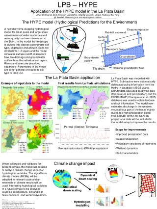
Evapotranspiration. Rainfall, snowmelt. Surface runoff. Macropore flow. Groundwater. N&P pools. Groundwater. Groundwater outflow. Regional groundwater flow. Tile drain. RCM. GCM. Dynamical down scaling. Statistical down scaling. Hydrological modelling.

E N D
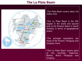
Evapotranspiration Rainfall, snowmelt Surface runoff Macropore flow Groundwater N&P pools Groundwater Groundwater outflow Regional groundwater flow Tile drain RCM GCM Dynamicaldown scaling Statistical down scaling Hydrological modelling The HYPE model (Hydrological Predictions for the Environment) LPB – HYPEApplication of the HYPE model in the La Plata BasinJohan Strömqvist, Berit Arheimer, Joel Dahné, Chantal Donnelly, Jörgen Rosberg, Wei Yang@ Swedish Meteorological and Hydrological Institute The La Plata Basin application • La Plata Basin was modelled with HYPE. Sub-basins were automatically delineated using information from the Hydro1k database (USGS 2000). ERA40 data was used as driving data (temperature and precipitation) and the ECOCLIMAP (Champeaux et al. 2005) database was used to obtain landuse and soil information. The model over-estimates discharge in the western mountainous part of the basin, mainly due to too high precipitation signal from ERA40. Within the CLARIS project local data will be included in the model setup to improve the results. • Scope for improvements • Improved precipitation data • Evapotranspiration • Regulation strategies of reservoirs • Wetland dynamics • Soil characteristics Example of input data to the model First results from La Plata simulations A new daily time-stepping hydrological model for small-scale and large-scale assessments of water resources and water quality has been developed at the SMHI. In the model the landscape is divided into classes according to soil type, vegetation and altitude. Soils are divided into 1-3 layers and the model simulates surface runoff, macropore flow, tile drainage and groundwater outflow from the individual soil layers. Rivers and lakes are described separately. Parameters in the model are either general or related to soil type or land use. Paraná (Station: Timbues) Overestimation due to ERA40 precipitation! Climate change impact When calibrated and validated for present climate, the model will be used to analyse climate change impact on hydrological variables. The signal from climate models (RCMs) will be adjusted to relevant scale and an ensemble of climate results will be used. Interesting hydrological variables in a future climate to be analysed could be soil moisture, low and high flow conditions, and wetland dynamics. References Champeaux, J.L., Masson, V. & Chauvin, F. (2005). ECOCLIMAP: a global databaseof land surface parameters at 1 km resolution. Meteorol. Appl. 12, 29-32. USGS (2000) Hydro1k (available online at http://edc.usgs.gov/products/elevation/gtopo30/hydro/index.html