Download
1 / 12
120 likes | 272 Views
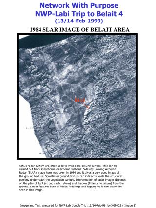
Network With Purpose NWP-Labi Trip to Belait 4 (13/14-Feb-1999). 1984 SLAR IMAGE OF BELAIT AREA. BL-4. Active radar system are often used to image the ground surface. This can be carried out from spaceborne or airborne systems. Sideway Looking Airborne

E N D
Network With Purpose NWP-Labi Trip to Belait 4 (13/14-Feb-1999) 1984 SLAR IMAGE OF BELAIT AREA BL-4 Active radar system are often used to image the ground surface. This can be carried out from spaceborne or airborne systems. Sideway Looking Airborne Radar (SLAR) image here was taken in 1984 and it gives a very good image of the ground texture. Sometimes ground texture can indirectly revile the structural geology underneath the vegetation canopy. Interpretation of radar images depends on the play of light (strong radar return) and shadow (little or no return) from the ground. Linear features such as roads, clearings and logging trails can clearly be seen in this image. Image and Text prepared for NWP Labi Jungle Trip :13/14-Feb-99 by XGM/22 ( Image 1)
1974 Aerial Photo of Labi area taken at different time of day and about 1 month apart Aerial photos are used very often in map making where topographic features such as roads and buildings can be traced out and digitised. Height information can also be extracted using stereo photos. In the first photo on the left, we can see some of the problem due to cloud covers and cloud shadows. BL-4 Sun angle also plays important role in the final outcome of the photo. Hill shadowing effects give us an impression of surface textures and thus the roughness of the ground below. In the next slide, we can see the map produced from the combination of photo interpretation work, land survey and hard copy map digitising method to compile the topographic map of Labi. BL-4 Image and Text prepared for NWP Labi Jungle Trip :13/14-Feb-99 by XGM/22 ( Image 2)
Topographical map of Labi area Image prepared for NWP Labi Jungle Trip :13/14-Feb-99 by XGM/22 ( Image 3)
Access Description to Old Belait Well No.4 (based on description from Sept.1992 survey by XTD/21 team updated in 1999 (dxt/15)) Belait Well BL-4 was spudded in 1914. To reach the well site, we have to drive to Labi village. Within meters of the road marker Labi-1Km there is a sand track leading off to the left (Red mailbox on left of the road). Follow this track for a few hundred meters and when the main track turns left go straight, uphill a rough rutted muddy track for about hundred meters. Park at the clearing top of the track. Then walk the downhill (about 100m) till the place where the track intersects Sungei Talingan (some concrete pipes under the road). Continue walking along the stream against direction of flow until a waterfall is reached. The journey up to this point takes about 30 minutes. Walk further for about 10 minutes and a second waterfall will be found, which is smaller than the first one. Approximately 250 meters from this waterfall is a small tributary stream, joining Sungai Telingan from the right hand side. Roughly 50 meters upstream from this point (along the main stream) an old steam engine will be found (now pieces of this have been moved down stream below the waterfall 28/1/99). Walk for another 5 minutes (100 meters) to the well location. In 19992 the well head for BL-4 was a conductor, sticking out 2.5 meters about ground level, with its top sealed off. At the base is a small pool of water with gas bubbles could be seen on the surface. A strong gas/oil odour was smelt. Now (1999) the casing has been cut off just above the surface and the conductor can be seen bubbeling away about 40cm below the soilsurface. H2S smell is very clear and the flow of water is estimated as at least 100bbl/day which causes the casing to tremble notably. Image and Text prepared for NWP Labi Jungle Trip :13/14-Feb-99 by XGM/22, XTD/2 ( Image 4)
Belait; Exploration History Eighteen wells have been drilled in the Labi area between 1912 and 1988, but only the last ten (post-1953) were wireline logged and drilled deeper than1300 metres. The first Belait well, at Bukit Puan, near the Belait river, did not test the Belait structure. The early history was of cable-tool drilling with repeated oil shows and gas blow-outs. Well 2 was the only significant producer. Other wells found a variety of crudes ranging from 15-44° API (970 to 800 kg/m3). Reservoirs are very thick coastal plain sands with few marine intercalations. The Miocene sedimentary sequence is overall regressive from the deep marine, Setap Shale Formation at the base to the coastal plain sediments of the Belait Formation at the top. Closures probably occur in both the box-folded upthrust block and in the underthrust block. Most exploration activity was in the Talingan area. This and the area further south are structurally very complex. The very sandy (main objective) sequence of the Belait Formation and the main regional cap rock, the Belait Clays, both crop out in the anticline. The structure is therefore prone to leakage in these areas as shown by numerous oil seeps. Northeast of the area () and away from the fault zone, the axis of the Belait anticline swings towards a more northeasterly orientation and plunges towards the Belait river (). This area was tested by exploration well Belait-11 on the river bank at Bukit Kandol with negative results. All parts of the Belait structure connect with potential oil kitchens on both flanks in the Badas and Belait synclines. These synclines contain thick coaly horizons (locally true coals) which are excellent source rocks. The deeper basinal Setap Shales could also contain good source rocks. In the extreme south of the structure around Bukit Teraja, where well Belait 14 was drilled, uplift on the fault-zone is very considerable, as is removal of former overburden by erosion. Reservoir properties are hence rather poor even at shallow depths. Geological exploration of the Belait anticline began about 1911, with geologists of the British Borneo Petroleum Syndicate, mapping the area as far south as Bukit Teraja. The first well was spudded in 1912 at Bukit Puan, on the south bank of the Belait river, to satisfy license obligations. In 1913, the syndicate acquired the Rampayoh Mining Lease, covering an area of strong surface hydrocarbon indications. They started drilling at sites no. 2 and no. 3 in the Talingan area, at the crest of the Belait anticline, with oil impregnated outcrops nearby. The Anglo-Saxon Petroleum Company (part of the Shell group of companies) took over the drilling operations in 1914. They struck oil in well no. 2 at a TD of 559 metres; the first oil in Brunei. Well no. 3 was discontinued at 165 metres, without hydrocarbons. Anglo-Saxon and the Nederlandsche Koloniale Petroleum Maatschappij were intermittently active in the area from 1914 to 1922. They drilled well no. 4 in an area with numerous gas seepages. The well had many gas and few oil shows. The British Malayan Petroleum Company (Shell) took over the British Borneo Petroleum Syndicate concessions in 1924. Subsequently the area was remapped. Well no. 2 was cleaned out and put on production in 1924. Between 1924 and 1931 some 5,000 m3 of 22° API (920 kg/m3) oil was transported by rail to Kampar and from there shipped down the Belait river. The company drilled six more wells from 1924 to 1931. Wells no 5, 8 and 9 appraised the producing Talingan area. They discovered mainly gas and minor amounts of heavy and light oil. Wells no. 6 7 and 10 (the first rotary well in Brunei) were outsteps to the north and east. They found new hydrocarbons, but none was considered commercial. Production and exploration activities stopped in 1931.The Seria oilfield provided better opportunities during this period of world economic depression. Exploration returned in 1948 with a seismic survey at Medarram and Teraja, but without delineating distinct prospects. Contractual obligations led to the drilling of wells Belait-11 to 14 between 1953 to 1955. The results of the widely spaced wells were disappointing as they failed to find new hydrocarbons. Exploration turned to the offshore in the late 1950's and only returned to the Belait area in the early 1970's. New seismic was acquired between 1975 and 1977 and two wells (Belait 15 and 16) were subsequently drilled in 1978. Belait 16 found interesting gas shows, but these could not be adequately tested because of technical problems. The Talingan area appeared to be the only one with further opportunities. New seismic was shot over this area in 1985 and Belait-17 was spudded in 1987 as a twin well of Belait-5. Belait-18 spudded in 1988 as a sidetrack of Belait-17 to evaluate the east flank of the Talingan accumulations. This well was the first one in 60 years with new, but non-commercial, hydrocarbons in the Belait area. Text Prepared for NWP Labi Jungle Trip :13/14-Feb-99 by DXT/15 Data (from Sandal 1996)
STRUCTURAL SETTING The Belait anticline is situated some 30 km inland from Seria in the Labi hills (). The area has a rugged topography and is predominantly covered by primary rainforest. The geology is dominated by a northerly trending anticline with numerous surface hydrocarbon indications. Despite intensive exploration campaigns since the beginning of this century, no large hydrocarbon accumulations have been discovered. BELAIT 4 Drilling commenced on 1 June 1914 and the well drilled to a depth of 1490’. In November 1914 work was abandoned after derrick and casing troubles. Drilling resumed in April 1915 to depth of 2132’ (TD).Shows of oil were reported at 1718’ and strong gas shows at 2049’. Numerous mechanical difficulties followed and the well was abandoned in June 1916. At the beginning of 1924 gas was flowing wildly through the damaged 7” casing. This flow was controlled and gas production began from the well in April 1924 at a rate of 0.5 mmscfpd . The well was connected by a 3” gas pipeline to the BL-5 well and was used to run a pump at the BL-2 well. Gas production stopped in April 1929, the casing apparantly collapsed or rotted away. Prepared for NWP Labi Jungle Trip :13/14-Feb-99 by, DXT/15 Data (DXT/3) ( Image 5) BL-4
ROUTE MAP TO BL-4 Pictures taken from previous trips to BL-4 showing the beautiful if somewhat wet jungle of Labi. Spot the labi-labi in the top picture (on the left). Prepared for NWP Labi Jungle Trip :13/14-Feb-99 by XGM/22, DXT/15 ( Image 6)
An extract from ‘ The Discovery & Development of the Seria Oilfield’ by G.C.Harper. 1975 Drilling In the Good Old Days……….. Prepared for NWP Labi Jungle Trip :13/14-Feb-99 by XGM/22 ( Image 7)
Photos from Latest walk to Bl-4 Starting at the end of a dirt track we park and walk along a hunting path Some natural seeps near the start of the track Soon we reach the Telingan river and follow this for about half an hour till the first waterfall
Tough climb from the river bank up steep slope on the way to Belait-4 from the 1st waterfall. Some more metal bits found downstream from previous ‘clean-up’. Some metal parts of an old steam engine found at BL-4 in 1995. The following cleanup campaign left lots of pieces scattered in the river. These where spottted during our last visist on the 27/1/99.
The path towards BL-4 leads through the river over slippery rocks and fallen trees so make sure you are sure footed. You will have to climb around two waterfalls but ropes are provided on the difficult bits. There are Plenty of beautiful natural waterfalls like this one with plenty of chance for bathing and taking lots of pictures (if you haven’t dropped your camera in the river yet, that is!).
Photos from Latest walk to Bl-4 (here we can see Dullah(DXT) wants to prove that he had been there, seen it, took the photo but not quite bought the T’shirt yet) Sign posted but the group nearly missed it! Thick jungle and wet ground ensure that the task of finding the well head a challenging one, especially if you never been there before. The well conductor is bubbeling wildly and feeds a small waterfall