Download
1 / 18
180 likes | 285 Views
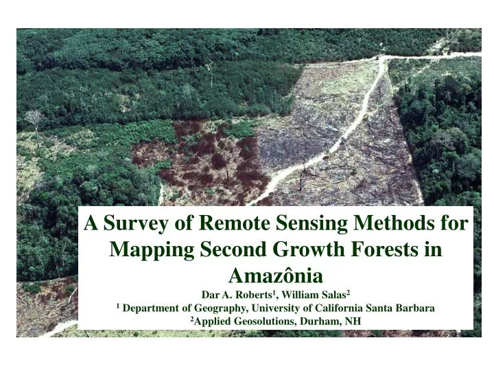
A Survey of Remote Sensing Methods for Mapping Second Growth Forests in Amaz ô nia Dar A. Roberts 1 , William Salas 2 1 Department of Geography, University of California Santa Barbara 2 Applied Geosolutions, Durham, NH. Why Study Second Growth?. It is an important land-cover class

E N D
A Survey of Remote Sensing Methods for Mapping Second Growth Forests in AmazôniaDar A. Roberts1, William Salas21 Department of Geography, University of California Santa Barbara2Applied Geosolutions, Durham, NH
Why Study Second Growth? • It is an important land-cover class • Fallow stage of swidden agriculture • Land-cover class following pasture abandonment • Natural regeneration following disturbance • It has a potentially important role in carbon balance • It represents a sink for carbon • Sink strength may vary depending on • Carbon accumulation rates • Areal extent • Persistence across the landscape
Interesting Research Questions • How much is there? • Where does it originate? (previous land-use or land cover) • How much carbon does it accumulate? • How long does it persist? • How is remote sensing used to help answer these questions?
How much second growth is there and how long does it last? • Basin wide estimates • Lucas et al., (2000): 35.8% of cleared lands prior to 1992 • Combines AVHRR analysis with INPE estimates of cleared lands • Fearnside (1996): 47% • Regional variability • The amount of cleared land in second growth varies considerably • Moran et al. (1994): Western Altamira, 46% (1985), 82% (1991) • Skole et al. (1994): Rondônia, 30% • Roberts et al., (2002): Rondônia, 22% • Ballester et al. (2003): Jiparaná Basin, ~ 11% • Persistence • Rarely quantified, but probably varies regionally • Skole et al., (1994): Second growth rarely persists 7 years in Rondônia.
How much carbon does it accumulate? • Carbon accumulation rates vary • They range from 35 Mgha-1yr-1 near Manaus to less than 2 Mgha-1yr-1 in the Bragatina zone • Modifying factors • Prior land use • Number of burns or fallow cycles • Years as pasture, stocking levels • Soil fertility • Other environmental factors • Estimates • Lucas et al. 2002: 7.2 to 35.5 Mgha-1yr-1, Manaus • Cecropia (16 yrs vs 2 yrs) • Alves et al. 1997: 3.5 to 10 Mgha-1yr-1, Rondônia • Banana, rice, burning (3.5), cacao, abandoned in 3 years (10) • Vieira et al. 2003: 0.7 to 2.6 Mgha-1yr-1, Bragatina Zone • Multiple cycles
Sources of Uncertainty (Volume I) • Definitions of second growth • Floristic, architectural, survey, remote sensing • Land-cover versus Land-use • Is it dirty pasture or initial regeneration? • Classification schemes • Age based classes • Vieira et al. (2003); initial (3-6), intermediate(10-20), advanced(40-70) • Santos et al. (2003): initial (<5), intermediate (5-15), advanced (> 15) • Architectural classes • Moran and Brondizio (1998), Lu et al. (2003) • SS1 (<6), SS2 (6.4-11.2), SS3 (8.73-14.45), SS4 (11.5-20.27), height (m) • Other criteria include basal area, stand volume, stem diameter etc. • Radiometric classes • Lucas et al. 2002: • Stages 1-4 (<5, 5-9, 9-20, 20+ yrs) • Depends on red and NIR changes during succession
Sources of Uncertainty (Vol II) • Confusion with other land-cover classes • Mature forest vs advanced second growth and sunlit crowns • Dirty pasture vs second growth • Confusion due to phenology • Interannual variation in precipitation • Second growth “increases” in early dry season images
An example from Manaus Second growth is fairly obvious, either dominated by Vismia or Cecropia
An example from Rondônia 11-14 year old second growth begins to blend with mature forest Sunlit crowns look like second growth
Is this Pasture or Second Growth? Digital Videography: 19990621:18310615 Powell et al., 2004: Agreement between interpreters was ~ 50%
Objectives • Develop a survey to determine how remote sensing is used to map second growth in the LBA community • Important questions • How are remote sensing scientists defining second growth? • Where are they working? • What kinds of data are they using? • How are the data preprocessed? • Which classification techniques were used to map it? • What kinds of products were produced? • Is the study supported with plot data? • What other types of ancillary data do they have?
Example question • 7) Which remote sensing parameters have you extracted for second growth? Please consider the following list. If some are missing, please add them in the space available: • Remote sensing parameters extracted • Spectral properties • Sensor • Units (DNs, TOA Refl, Surface Refl.) • Atmospheric Correction? (If so, how?) • Radiometric Nomalization? (If so, how?) • Biophysical properties (if an equation was used, please specify) • LAI • APAR • Fractional Cover • Biomass • Height • Other ______ • Areal measures (Specify unit of study area (ie, scene based, municipio) • Second growth extent • Ratio of SG/Cleared lands • Other _______ • Temporal Measures • Second growth age • Successional state (seral stage?) • Persistence of second growth • (mean residence time, max/min, percentiles) • Additional Measures
Example question • 8) Do you have prior land-use history? • If yes, how was it determined (ie, surveys? remote sensing surrogates?) • What types of information do you have? Please consider the following list • Time since initial disturbance • Pasture, perennial crops, annual crops, swidden systems • Cattle density • Frequency of disturbance • Burn history (# of burns prior to abandonment) • Other_____ • 9) What other types of supporting data do you have? • GIS layers (if yes, which?) • Soils, topography, • Other (list) • Stand data • Age • Size • Shape • DBH • Tree height • Tree density • Species composition • Biogeochemical measures
Responses • November, 2003: final survey drafted in Fortaleza • February, 2004: Surveys sent to 14 likely respondents • February to June, 2004 • 8 surveys returned • Although only slightly more than 50% responded, many of the responses were very comprehensive
Brondizio/Moran Brondizio/Moran Lucas, Roberts Steininger Vieira Alencar Brondizio/Moran Hagen/Salas Hagen/Salas Lucas Brondizio/Moran Roberts Roberts Hagen/Salas Steininger Study Locations Brondizio/Moran Brondizio/Moran Lucas, Roberts Steininger Vieira Brondizio/Moran Alves
Over 230 plots in Survey Responses Plot gap across two soil types Plot locations 2001 MODIS as background GSDY stratification (Zarin et al., 2001)
What’s next? • Fill survey gaps • Missing sites we know of • Machudinho (Rondônia) • Acre • Tapajós (Para) • Possible follow-on activities • Site comparisons • Ariquemes (Roberts, Salas) • Manaus (Roberts, Lucas, Steininger) • Pará (Multiple sites, Salas, Alencar, Moran/Brondizio) • Compare techniques, classification schemes and measures • Is the amount of second growth mapped the same? • How does classification scheme impact measures • How does SS1 or Stage-1 relate to dirty pasture? • Basin Wide Synthesis (Salas) • Synthesis of basin wide mapping (MSU, INPE, Asner) with detailed site studies and multitemporal analysis • Requires “normalization” of definitions, methods and results • Fill site gaps • Identify studies within the GSDY gap