Download

1 / 24
250 likes | 518 Views
The Impacts of Hurricane Katrina using GIS Software. Patrick Hogan April 20, 2011. Abstract.

E N D
The Impacts of Hurricane Katrina using GIS Software Patrick Hogan April 20, 2011
Abstract • Hurricane Katrina was analyzed with data from MARIS and FEMA (shown in slide 5). The objective of this project was to compare the surge elevations in southern parts of Louisiana and Mississippi. I plotted surge contours on the Katrina states map from the data collected. The majority of Louisiana is below sea level and thus had a lot of flooding. Parts of Mississippi are also below sea level, but the brunt of the damage in Mississippi was caused by the strong forced winds. It is shown that damage is greater in the northeast quadrant of Katrina.
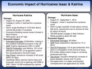
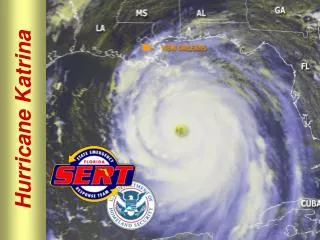
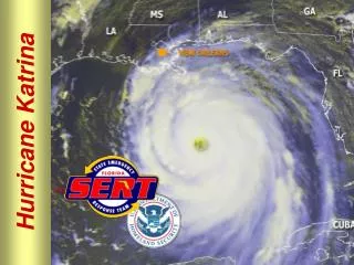
Hurricane Katrina Overview • Sustained winds during landfall of 125 mph (110 kts). • Category 3 at landfall • Central pressure the third lowest on record at landfall (920 mb). • Cost the Gulf Coast states as much as an estimated $125 billion. • Main states affected were LA, MI, AL. Source: NOAA and NCDC, http://www.katrina.noaa.gov/
Objective • Find damaged regions by looking at data from: • Orleans Parish • Harrison county • More damage to the right or left of the track of Katrina? • Create contours to see surge • What is ABFE? • A base flood elevation (BFE) is the height, relative to the mean sea level, that has a one percent chance of being equaled or exceeded by flood waters in a given year. It is one of the key building standards required for communities participating in the National Flood Insurance Program (NFIP). • ABFE is a branch of BFE, but based off of recent events such as Katrina Source: FEMA
The Data • Imported data from • Federal Emergency Management Agency (FEMA) • http://www.fema.gov/hazard/flood/recoverydata/katrina/katrina_la_gis.shtm • Mississippi Automated Resource Information System (MARIS) • http://www.maris.state.ms.us/HTM/DownloadData/Katrina.html
Procedure • Create an elevation input raster. • Create contours by importing the elevation raster given in the data by using the Arc toolbox. • Make contour interval as 1 • Use the identifier and attribute table to analyze the surge contours.
Category 3 when hit main land Source: FEMA
Aerial Photos (survey of Damage) Southern Mississippi Downtown New Orleans Source: NOAA
Louisiana Surge Inundation Estimated Rebuild Advisory Base Flood Elevation
Louisiana Elevation New Orleans Location of Interest
Below Sea Level Below Sea Level
Surge Elevation Contours 0 8 9 12 4 7 5 10 11 13 15 14 6 16 New Orleans 17 3 16 5 6 3 4 5 6 7 8
Advisory Base Flood Elevation (ABFE) New Orleans
Estimated Rebuild New Orleans
Louisiana Conclusions:Why was Katrina so devastating for LA? • Majority of Orleans parish is below sea level. • Katrina affected very populated regions like New Orleans. • Estimated rebuild was over a very large area
Mississippi Surge Inundation River Cutoff Advisory Base Flood Elevation
Mississippi Elevation Location of Interest
Surge Elevation 24 23 25 22 21 20
ABFE and Surge Limit Surge Limit ABFE
Mississippi Conclusions: Why was Katrina so devastating for MS? • Seems more destruction in MS. • Affected very populated areas (coastline) • East side (northeast quadrant) of Katrina had greater damage