Download
1 / 21
220 likes | 347 Views
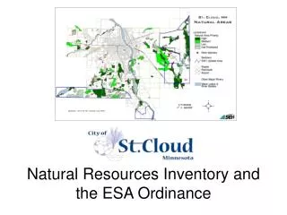
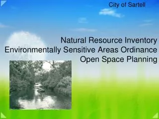
Natural Resource Inventory Environmentally Sensitive Areas Ordinance Open Space Planning. City of Sartell. Located in Central Minnesota along the banks of the Mississippi River, Sartell is one of the fastest growing communities in the region! . Physical Characteristics

E N D
Natural Resource InventoryEnvironmentally Sensitive Areas OrdinanceOpen Space Planning City of Sartell
Located in Central Minnesota along the banks of the Mississippi River, Sartellis one of the fastest growing communities in the region! • Physical Characteristics • 2006 Population Estimate—13,900 (41% increase from 2000 census) • 5.95 square miles and growing (+315 acres on average annexed per year) • 2006 Development Statistics: 105,000 sq. ft of new commercial building, 261 new single family lots, 227 new townhome lots, 23 new commercial lots,125 SF building permits • 37 parks • 38 miles of pedestrian trails
Why, WHAT and How?? Why?? Comprehensive Plan Public Desire for Protection Mandates (NPDES) WHAT?? What is or isn’t Currently Protected? What Features are Unique to Sartell/LeSauk/Sauk Rapids? What Features do we Value? HOW?? Short Term Protection/Long Term Protection NRI and Ordinance
• Past Preservation Initiatives Creekview Preserve • Watab River • DNR Grants Applications • Local Option Sales Tax • Natural Resource Inventory Preservation Protections •Landscaping Ordinance (1989) •Comprehensive Plan (2003) •Storm Water Pollution Prevention 2003) •Wetland Ordinance (2003) •Subdivision Ordinance (2005)
Future Preservation Actions • Regulatory Options Short Term -Interim Ordinance –Annexed Properties Long Term (Create a Community Based Task Force) -Open Cutting and Clear Cutting within the City shall require a Conditional Use Permit except along shorelines or steep slopes (Nisswa) -Open Cutting and Clear Cutting within those areas identified as environmentally sensitive shall be reviewed (St. Cloud and Sartell Interim Ordinance) -No regulations on clear cutting prior to development – meet goals through education and conservation programs
Environmental Sensitive Ordinance Task Force Council Initiated Task Force Creation – September 2005 Met every other week for 7 months Explore Environmental Protection Models Voting Members Tryg Hanson, Parks Commission Sandy Cordie, Planning Commission Steve Feneis, Economic Development Commission Mike Larson, St. Cloud State University Robert Sip, State of MN Bruce Johnson, River Council of MN Constance Holth, MN Dept. of Agriculture Wendy Hulsebus, Synergy Development Mark Osendorf, Xcel Energy Scott Reinert, Showcase Properties Non-Voting Members Linda Peck, Retired, Audubon Society, SCAEC Wayne Cymbaluk, Stearns County Soil and Water Conservation District Jane DeAustin, Central MN Builders Association Staff/Other Non-Voting Members Anita Rasmussen, Sartell Planning Director Jean Coleman, Mississippi River Renaissance
The Why! • 1. Protect, conserve and enhance natural resources and ESA’s for community’s long term environmental and economic benefits. • 2. Recognize the Mississippi, Sauk, Watab and other rivers as assets to the community. • 3. To conserve and improve ESA’s. • 4. To protect, preserve and enhance the supply of clean water and clean air for the current and future generations. • 5. To restore and re-establish native vegetation. • 6. Establish balance between protection of- and urban use of- natural resources.
The Why! • 7.Provide for the orderly growth and development. • 8. Promote flexible site planning and allow for a mix of housing types. • 9. Encourage coordination between city, county, state and federal agencies concerned with natural resources. • 10. Encourage cooperation through joint planning and development with neighboring communities to protect, preserve, and enhance our shared natural environment. • 11.Encourage early cooperative planning between landowners/developers, the City and scientific experts in natural communities and resources.
The Why! • a. Identify and prioritize environmentally sensitive areas • b. Aid developers in the creation of their development plans • c. Aid City staff, the Joint Planning Commission and City Council in their assessment development plans in ESA’s • d. Provide flexibility in the planning process when needed to balance environmental and economic goals
The Why? May-June 2006: Community survey(s) conducted. The following summarizes the percentage of responses that rated funding for certain features or amenities in our community as important or very important: Protection of natural areas and habitat 91% Land acquisition for natural areas, open spaces & nature parks 89%
The What! • 1. Surface waters • 2. Floodplains • 3. Sensitive groundwater area • 4. Storm water management • 5. Wetlands • 6. Sensitive geological features • 7. Forests and wooded areas • 8. System Connections • 9. Habitat • 10. Non-woody upland vegetation/prairie
The What! The priority of importance among the features are determined based on the presence of one or more of the following characteristics: 1. Degree of disturbance 2. Rarity 3. Biodiversity 4. Interconnectedness 5. Size 6. Ecological Sensitivity (
General Provisions • Regulated Activities (subject to ordinance) • Subdivision of land • Land alterations • New roads, bridges, road expansion, utilities B. Exemptions • Otherwise regulated (Wetland Ordinance, WCA, etc) • Prior approvals (preliminary and final platted properties) • Public projects • Maintenance • Emergency • Utility poles • Agriculture • Unplatted property C. Hierarchy of Protection and Development Guides 1. Hierarchy of Protection (Most Important, More Important, Important) 2. Development Guidelines Maximize the protection while proving an opportunity for equitable economic return for the development
Natural Resource Inventory/ Environmentally Sensitive Area Designation Not Exempt Exempt Site Planning Process Planning Office Sketch Plan Activate Environment & Development Team Site Planning Process Planning Office Concept Plan and Natural Resource Management Plan Concept NRMP Rezoning, Preliminary Plat and NRMP Prepared and Submitted to Planning No Platting Required EDT Review Re-Zoning/EPUD/Platting Park and/or Planning (PH) Commissions Review and Recommend Planning Commission PH Planning Office Approve Concept Plan and NRMP City Council PH and Review Final Plat and NRMP Review by Planning Commission and City Council
WHAT ELSE???? Natural Resource Inventory Initial inventory funded by DNR, expanded with funding from the McKnight Foundation. This provided roughly 2/3 of coverage for the growth boundary, City of Sartell funded the rest. Park and Open Space Planning Local Option ½ Cent Sales Tax Priority Athletic Facilities River-Greenway Corridors Future Land Use Planning Review of FLU plans based on transportation and environmental features Environmental Reviews Robert’s Road and 50th Avenue Realignment Highway 15 AUAR Other Identify Eagle Habitat Along Mississippi River Native Prairie Restoration Areas
Results of Conducting ESA on TH #15 Site Open Space Green space requirement was increased from baseline 20% to 35% On Site Mitigation Wetlands – required on site mitigation of all impacts – doubled size of wetlands on site Trees and Vegetation – 20,000 perennial plants, 1,000 shrubs and 500 trees Negotiation for Reduced Impervious Sam’s Club and WalMart reduced parking requirments from over 6 units per 1,000 to 4.6 units per 1,000, significantly reducing runoff volumes.
Good, Bad and the Ugly – Lessons Learned1. Natural resource protection should not stop at a city border2. Be proactive3. Base decisions on science and fact – NOT emotion4. Be inclusive 5. Move the process along……………..
For additional information regarding the Environmentally Sensitive Ordinance and NRI Please contact: Anita Rasmussen, AICP Planning and Community Development Director 320-258-7306 anita@sartellmn.com City of Sartell website: www.sartellmn.com