Download
1 / 11
110 likes | 431 Views
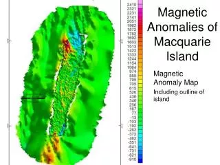
Magnetic Anomalies of Macquarie Island. Magnetic Anomaly Map Including outline of island. Magnetic Anomaly and Anomaly due to Magnetized terrain. Uniformly magnetized terrain. The uniformly magnetized terrain allows us to distinguish anamolies associated with topographic highs

E N D
Magnetic Anomalies of Macquarie Island • Magnetic Anomaly Map • Including outline of island
Magnetic Anomaly and Anomaly due to Magnetized terrain Uniformly magnetized terrain • The uniformly magnetized terrain allows us to distinguish anamolies associated with topographic highs • Most of the highs in the north we see are not associated with topography, so have another source Topographic High, Magnetic Low Topographic and Magnetic High
SPOT Image • Processing problems mean the colors are slightly distorted and the image cannot be properly georeferenced • Green hues are indicative of vegeatation • Red are supposed to represent iron alterations like smectite, but especially along the high coastal cliffs in the NW section of the island are more likely errors • The cyan blue represents bare, altered rock • Alteration seems centered on the northern part of the island, falling almost entirely in the ultramafics
To the west- beds dip at steeper angles- burial occurs closer to the island. The topography and magnetic signature suggest a narrow, steep valley just to the west of the island- possibly a graben To the east of the island the magnetic signatures suggest buried sources- the dip is low and material is buried little by little Offshore Structures
Horizontal Gradient Method Dolerites • Method looks for edges of magnetic bodies or contacts • Low area in central northern and southern parts of island corresponds very well with the dolerites • The areas of highest magnitude correspond well with possibly altered faults • Structures offshore align N-S directions of the Macquarie Ridge Complex Altered Faults
Local Striations Local Magnetic striations roughly coincide with regional patterns The local NW-SE striations are almost 90° off the regional magnetic ‘stripes’ NE-SW magnetic reversals
Large Features in the North Large negative feature in blue • This large negative feature in the mag could be a large reversal, but has a very steep gradient boundary • Originally we thought it was compositional- but seen here, further south, it roughly follows the ultramafic (blue)/dolerite (orange) boundary, but in the north it bisects the gabbros (green) • It could be a reversal, seems to be supported by paleomag, several sites on the east coast in this area are reversed, but other sites in the region are normally magnetized • Roughly along the change there is a fault that some authors believe is a relict spreading transform fault • This low ends abruptly at the basalt (yellow)/ dolerite boundary on North Head • Very large positive anomaly could be loading- also does not seem to be compositional • On the west coast near the Finch-Langdon fault some beds are overturned, this could be a contributing factor, but Gascombe and Everard (1999) say these are local around the faults • Both features continue offshore to the NW until buried Magnetic Anomaly overlain by geology: orange silhouette is dolerites, yellow are basalts, green are gabbros, and blue are ultramafics. White line near North Head is 1,820 m long
Full Tilt Derivative • Tilt Derivative calculates the horizontal location and depth of magnetic sources and mapping shallow basement structures • Findings show the depths of magnetic sources on the island are very near surface and within .02km of the surface • The offshore striations are nearly N-s to the west • Especially offshore, the data is very noisy • Other methods for depth calculation have had mixed results
Faults • Blue outline of the island includes pink shapes of possibly altered areas as determined by combination of LANDSAT, magnetic lows, and topographic lows. Mapped faults from geologic map and include spreading faults (yellow), other faults (green) (Wertz et al, 2003), and possibly altered faults (purple) • Spreading faults align along NW-SE striations seen in magnetic data • Offshore faults are trend N-S, the same orientation as the Macquarie Ridge Complex
Reversal? • The low in this region (all basalt-orange outline) occurs along a topographic ridge. This suggests it is a magnetic reversal • Area of bedrock not covered by sediments • The overall fabric of the area seems to be striking NE, which is the orginal direction of spreading • Gascombe and Everard called the block on the east coast of this part of the island as BIVa and believe this block of the island preserves seafloor fabric of spreading (1999) • the mag values range from about 500 to 800 nT and in the low region the values are from -400 to -1000. This probably isn’t simply alteration because the values are too low (should be around 0nT). Area of low magnetization Magnetic Anomaly overlain by geology: orange silhouette is dolerites, yellow are basalts, green are gabbros, and blue are ultramafics. Yellow transect is 5,420 m long.
To Fault or not to Fault • Finch-Langdon fault in the north is a fault system with many fault segments, most written about feature on the island, but not very prevalent in the mag • Only two segments have topographic expressions (Wertz et al, 2003) which may be complicating the results • Hydrothermal alteration is observed, but only within 1 km of the fault at most (other areas is meter or even cm-scale) (Wertz et al, 2003) which would further obscure the fault • The literature says that the older, relict faults should be associated with hydrothermal alteration, in some places rather extensive alteration, especially a region in the south (Rivizzigno and Karson, 2004), but none of these regions show obvious magnetic signatures expected of alteration. • Major Lake Fault Zone in the South does not appear on the regional geological map as seen in the paper (Rivizzigno and Karson, 2004) • This region in the mag has a low associated with it, from about -20 to under 100 nT • Region also has an outcrop of sheeted doleritic dikes • Goscombe and Everard place the important fault in this area in a different location- but this falt doesn’t display the same low anomalies- the two papers agree on the location along the east coast, which does show low anomalies Magnetic Anomaly overlain by geology: orange silhouette is dolerites, yellow are basalts, green are gabbros, and blue are ultramafics. White line is 1,400m long