Download
1 / 7
70 likes | 206 Views
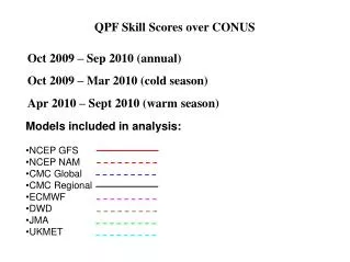
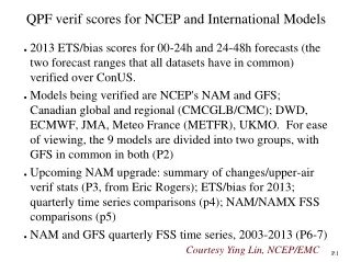
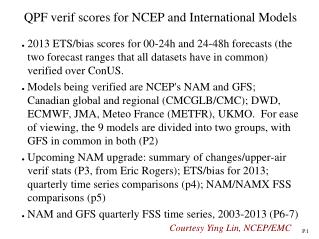
QPF verif scores for NCEP and International Models. 2013 ETS/bias scores for 00-24h and 24-48h forecasts (the two forecast ranges that all datasets have in common) verified over ConUS .

E N D
QPF verif scores for NCEP and International Models • 2013 ETS/bias scores for 00-24h and 24-48h forecasts (the two forecast ranges that all datasets have in common) verified over ConUS. • Models being verified are NCEP's NAM and GFS; Canadian global and regional (CMCGLB/CMC); DWD, ECMWF, JMA, Meteo France (METFR), UKMO. For ease of viewing, the 9 models are divided into two groups, with GFS in common in both (P2) • Upcoming NAM upgrade: summary of changes/upper-air verif stats (P3, from Eric Rogers); ETS/bias for 2013; quarterly time series comparisons (p4); NAM/NAMX FSS comparisons (p5) • NAM and GFS quarterly FSS time series, 2003-2013 (P6-7) Courtesy Ying Lin, NCEP/EMC
QPF Skill Scores over ConUS, Jan – Dec 2013, 1 &2 day fcsts Eq. Threat Eq. Threat 1.0 Bias Bias GFS,NAM,CMCGLB,CMC,JMA GFS,DWD,ECMWF,METFR,UKMO
Changes planned for NAM implementation in Spring 2014 Vector Wind RMS (m/s) 12km CONUS 1 Oct 2013 – 15 Jan 2014 Physics modifications: • GWD/mountain-blocking; more responsive to subgrid-scale terrain variability • BMJ convection: moister convective profiles, convection triggers less, increase 12km bias • RRTM radiation, latest version • Ferrier-Aligo microphysics, tuned to improve severe storm prediction • Improved snow depth algorithm in LSM Parallel Ops Day 1 = Black Day 2 = Red Day 3 = Blue Data assimilation modifications: • Hybrid variational-ensemble analysis with global EnKF • New satellite bias correction algorithm (same as in FY14 global upgrade) • Cloud/radar assimilation in NDAS NAMvs. NAMX (para) 1/2/3 day forecasts, 23 Apr – 30 Sept 2012
NAMvs. NAMX (para) 1/2/3 day forecasts, Jan – Dec 2013 NAMX: on-going NAM parallel experiment NAM, NAMX(dashed line) 24,48,72h forecasts, 2007-2013 ETS at 0.25”/day ETS Bias Apr 2012 NAMvs. NAMX (para) 1/2/3 day forecasts, 23 Apr – 30 Sept 2012
NAM, NAMX 24+48+72h FSS, 23 Sep 2013 - 17 Feb 2014 5mm/day 10mm/day 5km 300km 25mm/day 50mm/day
NAM 24,48,72h FSS at 62km scale, 2003-2013 5mm/day 10mm/day 25mm/day 50mm/day
GFS 24,48,72h FSS at 62km scale, 2003-2013 5mm/day 10mm/day 25mm/day 50mm/day