Download
1 / 59
590 likes | 613 Views
Explore the formation of blueschists in subduction zones through a numerical simulation of thermal structures based on the Huang et al. (2000) model. Learn about the unique characteristics of blueschists and the geological processes involved in their creation. Discover how these rocks are exhumed and carried up with mountain formations, surviving the journey intact.

E N D
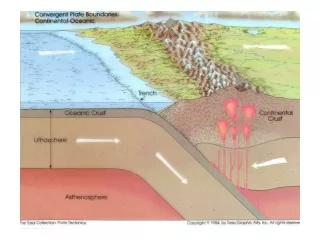
Numerical simulation of thermal structure for eastern Aleutian subduction zone 50 Ma after initiation (i.e., steady state) based on model of Huang et al. (2000).
Classic blueschists. Slight blue tinge results from the mineral glaucophane (an amphibole), which here forms the rather stubby needles. This rock started life as a volcanic rock of basic composition, part of the old ocean floor of Tethys. Blueschists are commonly thought to be diagnostic of former subduction zones, because they imply relatively high pressure conditions relative to the temperature (compared to normal geothermal gradients).
So – to make a blueschist, one needs a rock fairly suited to the earth’s surface, and then needs to shove this rock to some depth of higher pressure (anywhere from 10 to 20 km) while keeping it from getting too hot (say between 200C to 400C, which is relatively frigid for the interior of the earth at those depths). The place this happens is – in a subduction zone. A subduction zone is a margin between tectonic plates where one plate is overriding the other, and the overridden plate is going down, down, down into the depths of the planet. a general consensus: When large masses of rocks that aren’t very dense are taken down into deep levels of the earth (these could be sediments or granites), they are (compared to the far denser rocks surrounding them) relatively buoyant, and tend to rise up again, aided by the shoving processes present at colliding plate boundaries: this is a geologic process called exhumation. Immense mountains, such as Mount Olympus in Greece or parts of the Mighty Himalayas, are made of such relatively “light” rocks that were once dragged down into subduction zones and subsequently exhumed, a cycle that may happen in as little as 30 million years. The relatively rare blueschist rocks are carried up with these exhuming mountains, and seem to survive the journey quite wonderfully. http://the-earth-story.com/post/99132017287/its-blue-its-schist-its-blueschist
El Capitan Winter, Sunrise,Yosemite National Park, California, 1968
B,C: folds, reverse faults D, E: plutons, plate underplating
Solid barbs: accretionary margins Open barbs: erosive margin
Solid: tension parallel to Benioff zone Open: compression parallel to dip
Equatorial and circum polar currents Early Triassic, 245 Ma
Fig. 12.7 Ridge push: gravity Ridge resistance: brittle earthquakes Mantle drag: 8x greater under continents
Tholeiitic series: basaslt, low KCalc-alkaline: andesite, moderate KShoshonite: Alkaline: high K, rare
Age of the oceanic crust color-coded (red: youngest, blue oldest) illustrates the change in spreading rates from ~10 mm/year to ~170 mm/year Note the back arc basins