Download
1 / 17
170 likes | 348 Views
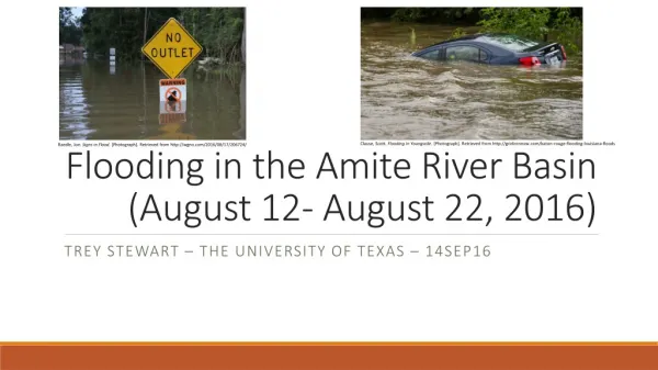
Flooding in the Amite River Basin (August 12- August 22, 2016). Clause, Scott. Flooding in Youngsvile. [Photograph]. Retrieved from http://gridironnow.com/baton-rouge-flooding-louisiana-floods. Raedle, Joe. Signs in Flood. [Photograph]. Retrieved from http://wgno.com/2016/08/17/206724/.

E N D
Flooding in the Amite River Basin (August 12- August 22, 2016) Clause, Scott. Flooding in Youngsvile. [Photograph]. Retrieved from http://gridironnow.com/baton-rouge-flooding-louisiana-floods Raedle, Joe. Signs in Flood. [Photograph].Retrieved from http://wgno.com/2016/08/17/206724/ trey Stewart – The University of Texas – 14Sep16
Research Goal • To report on the August 2016 flooding in Louisiana by looking at the following data: • Precipitation (NWS and USGS) • River Stage (USGS) • Elevation (USGS) • High Water Marks (USGS)
Flood Details • Historic amount of precipitation in south Louisiana • Over 2 feet in some locations • Most occurred within 2-day period (August 12-13) • 1000 year event • Stage records recorded in 8 Louisiana rivers • One Amite river gauge beat record by 6 feet! • 13 Deaths reported
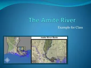
Watershed Location Amite Watershed Flowlines Nations Online Project. Map of Louisiana. [Photograph].Retrieved from http://www.nationsonline.org/oneworld/map/USA/louisiana_map.htm
Watershed Location Comite River East Baton Rouge Amite River Amite River Amite Watershed Flowlines Nations Online Project. Map of Louisiana. [Photograph].Retrieved from http://www.nationsonline.org/oneworld/map/USA/louisiana_map.htm
South Louisiana is Flat! Comite River East Baton Rouge Amite River Amite River Amite Watershed Flowlines Nations Online Project. Map of Louisiana. [Photograph].Retrieved from http://www.nationsonline.org/oneworld/map/USA/louisiana_map.htm
Precipitation Mapping Amite Watershed precipitation 8/12-8/13 (in inches) generated using Empirical Bayesian Kriging Method with precipitation station data Louisiana precipitation according to NWS August 9-August 16
Precipitation Mapping My Hometown Amite Watershed precipitation 8/12-8/13 (in inches) generated using Empirical Bayesian Kriging Method with precipitation station data Louisiana precipitation according to NWS August 9-August 16
Quantifying Precipitation • South Louisiana: • 7.1 trillion gallons of water • 3x more than Hurricane Katrina • Amite River Basin: • Average of 14 inches of precipitation • 0.5 trillion gallons of water Thiessen polygons for precipitation stations
Contour Affects Flooding Behavior • Flooding downstream lagged precipitation Amite and Comite Junction Amite and Comite Junction Baton Rouge Main Rainfall Occurred Amite Watershed Contour Plot – Lines indicate 10 m height difference
Contour Affects Flooding Behavior • Backwater flooding occurred south of Baton Rouge Amite and Comite Junction Tributary Stage Amite and Comite Junction Baton Rouge Main Rainfall Occurred Tributary Amite Watershed Contour Plot – Lines indicate 10 m height difference
High Water Mark Locations • High water marks indicate locations with >5 feet of flooding • Notice lots of flooding where Comite and Amite Rivers join Comite River Amite River Amite River Amite Watershed High Water Marks and Flowlines
High Water Mark Locations • At least 110,000 homes damaged across South Louisiana • Much flooding occurred outside FEMA’s “high-risk” zone • Most homes are not covered by flood insurance Amite Watershed High Water Marks and Land Cover
High Water Mark Locations • Flooding on I-10 and I-12 made them unusable from August 12th-16th • I-10 West of Baton Rouge remained closed until August 18th I-12 I-10 Baton Rouge Interstate Flooding
Final Thoughts and Next Steps • Conclusions: • Historic rainfall event requiring many days for water to drain • Damaged homes and loss of life • Buy flood insurance! • Next Steps • Map HAND for watershed to compare modeled flood inundation depth with HWM data • Determine total precipitation volume upstream from Comite and Amite River junction • Look at Amite River slope and the velocity of the stage peak
Acknowledgements • University of Texas • Dr. David Maidment • Paul Ruess • Louisiana State University • Dr. Clint Wilson
Questions? • References: • Ball, J. (2016, September 23). Louisiana Flood of 2016 made worse by growth-focused policies. Retrieved from NOLA.com: http://www.nola.com/news/baton-rouge/index.ssf/2016/09/louisiana_flood_of_2016_develo.html • Barney, A. (2016, August 24). Review of Historic Flooding in Louisiana. Retrieved from WeatherWorks: http://www.weatherworksinc.com/Louisiana-Floods-2016-Historic • Moscona, M. (2016, August 16). Historic flooding has brought Baton Rouge to its knees . Retrieved from gridironnow.com: http://gridironnow.com/baton-rouge-flooding-louisiana-floods • Samenow, J. (2016, August 19). No-name storm dumped three times as much rain in Louisiana as Hurricane Katrina. Retrieved from The Washington Post: https://www.washingtonpost.com/news/capital-weather-gang/wp/2016/08/19/no-name-storm-dumped-three-times-as-much-rain-in-louisiana-as-hurricane-katrina/ • Unknown. (2016, August 22). Death toll rises to 13 in historic flood. Retrieved from wwltv.com: http://www.wwltv.com/news/death-toll-rises-to-13-in-historic-flood/298408105 • Unknown. (2016, August 17). Historic flood death toll climbs to 12 after body found in Livingston Parish. Retrieved from wgno.com: http://wgno.com/2016/08/17/206724/ • Unknown. (2016, August 14). Louisiana Flooding: 4 Dead, 20,000 Rescued, 10,000 in Shelters, Drivers Still Stranded on Interstate. Retrieved from Weather.com: https://weather.com/news/weather/news/gulf-coast-flooding-latest-news-rescues-motorists-interstate • Wells, C. K. (2016, August 18). I-10 reopens in Lafayette after historic flooding. Retrieved from Nola.com: http://www.nola.com/traffic/index.ssf/2016/08/i10_reopens_lafayette_flooding.html • Wells, C. K. (2016, August 16). Louisiana flooding: Interstate 12 reopens, parts of I-10 still closed. Retrieved from Nola.com: http://www.nola.com/traffic/index.ssf/2016/08/i12_open_i10_closed_flood.html