Download
1 / 26
260 likes | 453 Views
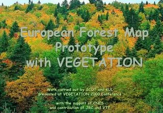
European Forest Map Prototype with VEGETATION. Work carried out by SCOT and KUL presented at VEGETATION 2000 Conference with the support of CNES and contribution of JRC and VTT. Objectives of the study. Assessment of the capabilities of VEGETATION for mapping forest at regional scale

E N D
European Forest Map Prototype with VEGETATION Work carried out by SCOT and KUL presented at VEGETATION 2000 Conference with the support of CNES and contribution of JRC and VTT
Objectives of the study • Assessment of the capabilities of VEGETATION for mapping forest at regional scale • Preparation of a European forest map prototype • with simple methods applied to standard VGT products (10 days composites S10) • Partners • JRC : methodology as developed for FMERS study • KUL : alternative approach for stratification • SCOT : processing • VTT : clustering method
Pan-Europeanstudy area Processing steps • Data : 21 composites S10 from April 1999 to October 1999 • Other data : CORINE LC, JRC/FIRS stratification of European forest ecosystems
Decade #2 October 1999 • Status map • Clouds in dark blue • Ice in light blue • Bad SWIR sensors in red Processing steps • Quality of VEGETATION S10 data • High visual quality • However • problems of SWIR sensors • cloud mask to be improved • remaining directional effects
S10 decade #2 October 1999 NIR/SWIR/R
S10 decade #2 October 1999 NIR/SWIR/R
CORINE Land Cover Processing steps • Stratification • utilisation of FIRS strata • alternative using landscape criteria • Spectral clustering • Selection of the most appropriate S10 for forest types discrimination and generation of a multi-spectral monthly composite • Stratified clustering of the monthly composite • Multi-temporal analysis of NDVI forest types • Mapping procedure
Stratification Two alternative location of cluster means in three ecosystem regions. A - means similarly distributed - no likely need for pre-clustering stratification. B - cluster means on the average different in different regions - a likely need for pre-clustering stratification.
Stratification FIRS stratification superimposed over VGT S10 # 2 October 1999
region IX region VIII region VI-VII region VI-VIII region V-VI north region VII region VI region IV-V region V-VI south region X region V region IV-VI region IV Stratification FIRS main regions after regrouping of main strata
Proportion of forest within 5x5 Km bloc from CORINE LC 0 % < 10 % 11-40 % 41-80 % > 81 % Stratification • Stratification alternative using landscape criteria • fragmentation patterns, e.g. Shannon index... • proportion of main land cover categories
expected to minimise directional effects Spectral clustering • Generation of a monthly composite • remaining clouds in all S10 products • selection of three S10 composites • D3 August 1999 • D1 September 1999 • D2 September 1999 • averaging procedure with elimination of bad pixels in the SWIR band and remaining cloudy pixels
Spectral clustering • Generation of a monthly composite 10 days composite #3 August 1999 monthly composite (#3 Aug / # 1 & 2 September 1999)
Monthly composite by averaging three decades D3/Aug, D1 and 2/Sept 1999 Spectral clustering
Clustering • Unsupervised clustering within each stratum into 50 classes • algorithm developed by VTT (Finland) and tested in the framework of FMERS for European forest mapping with IRS-WiFS data • based on homogeneous signatures within 2x2 pixels • automatic sort of the clusters according to their approximate biomass values
Clustering Likely location of the target classes in the spectral range (FMERS/VTT)
Broad-leaved Broad-leaved confusion mixed mixed Discrimination with SWIR band coniferous coniferous Clustering results • Unsupervised clustering within each stratum into 50 classes 15 20
Results • contribution of the SWIR band
April-May June-Aug Sept-Oct Results • NDVI temporal profiles • definition of temporal indicators • distinction of three “seasons” for better discrimination of NDVI profiles related to forest types • application to the 21 S10 composites
Colour composite NDVI three seasons
Results • Temporal profiles of main forest cover types
Results • Temporal profiles of other land cover types
Results • Temporal profiles of CORINE classes • Quality of CORINE classes ? • Variability of vegetation phenology within broad land cover classes
Coniferous forest Mixed forest Broad-leaved forest Evergreen vegetation Prototype of a European Forest Map derived from VEGETATION data
CONCLUSIONS • VEGETATION S10 products of very good quality : geometry, radiometry • but some improvements are still needed : correction of directional effects, cloud masking… • the spectral clustering approach is leading to promising results with simple methods and a few S10 products • dramatic potential of NDVI temporal profiles for discriminating vegetation types : combination with spectral clustering ? • need to improve and develop new standard products on NDVI profiles, e.g. phenology, … • products on land cover changes