campus map publishing system Prototype Project
campus map publishing system Prototype Project. UVM Transportation and Parking Services. agenda. Review Project History (8 minutes) Project Status Update (14 minutes) Plan for Future (8 minutes). Map Project History. project timeline. June 14, 2012 Purpose and Scope

campus map publishing system Prototype Project
E N D
Presentation Transcript
campus map publishing system Prototype Project UVM Transportation and Parking Services
agenda Review Project History (8 minutes) Project Status Update (14 minutes) Plan for Future (8 minutes)
project timeline June 14, 2012 • Purpose and Scope • S:\afs\TPS\TPS\2012\dpepper\20120601_projectManagement\output\project_01_purposeAndScope_201206151215.pdf • Major Goals Outlined: • Store… • map data in database • assets in “library” • Prepare to rapidly publish custom map products (w/data subsets): • Parking Lots by Permit Type • Residential Buildings by Permit Type • Bus Stops by Route • Allow combinations: • For example, Blue Permit: Parking Lots, Residences, and Bus Routes
project timeline August 9, 2012 • Interviewed GIS Analyst Stephen R. Smith • As Follow-up to meeting: • Researched UVM contracting process • Initiated laptop procurement • Contacted Campus Planning to request data • Project slowed/delayed due to… • Holidays, etc. • Laptop procurement delays • Assumption that hiring an expert at the beginning of the project would not have been cost-effective
project timeline January 9th, 2013 • Received ArcGIS Polygons for Redstone Campus: • Parking Lots • Buildings • Roads • Received tabular data in Excel/CSV: • Parking Lots • Buildings • Roads
project timeline January 15th, 2013 • Began “DB CRUD” Application • “CRUD” stands for “Create, Read, Update, and Delete” • basic SQL DML operations • Application’s main features • Model database designs with standardized features • IDs, timestamps, data type design patterns (e.g. FK-LU) • Generate “Create Table”, “Create View” scripts
project timeline (January 15th, 2013 continued) January 15th, 2013 (continued) • “DB CRUD” Application (continued) • Application’s main features (continued) • Generate standard web interfaces to database • Indexes: application, context • CRUD files • mixture of PHP, Javascript, HTML, CSS • Allows rapid development of web database applications • Maintains data in enterprise database • MySQL Server: webdb.uvm.edu, • Accessible to both web and desktop • Ended “DB CRUD” App development mid-June, 2013
project timeline June 26th, 2013 • Began process of building Campus Map Publishing System Prototype • Geospatial Specialist Teoman “Teo” Korkmaz joined project working on the design of the map prototype in ArcGIS • focusing on integrating database assets and ArcGIS assets • David Pepper focusing on rest of project • working on architecture, storage layer and project management
TPS CAmpus Map Publishing System Campus Map Publishing System Prototype • Storage design in “DB CRUD” generator system • Data in MySQL server: webdb.uvm.edu, Database: DPEPPER_1 (dev) • Web interfaces on dev website: • http://www.uvm.edu/~dpepper/2013/map/standard/index.htm • Access database linked to map database tables in MySQL • tpsCampusMap.accdb • S:\afs\TPS\TPS\2013\dpepper\20130626_makeCampusTPmapPrototype\ tpsCampusMap.accdb • ArcGIS project “CampusTPmap_prototype” • Located on “TPSGraphics” workstation at: • C:\2013\dpepper\20130703_makeCampusTPmapPrototype\ CampusTPmap_prototype.mxd
TPS CAmpus Map Publishing System Architecture of an ArcGIS Project • Layers like a hamburger • Assets linked to location on earth • Basic ArcGIS asset types: • Polygons (parking lots, buildings) • Points (locations of bus stops, bike racks) • Lines (bus routes)
TPS CAmpus Map Publishing System How the ArcGIS Project is Designed (top-bottom) • Points of Interest • Bus Layer • Stop Points • Route Lines Parking Lots • Parking Lots • dynamically formatted (“regular” or “selected”) according to Selected Permit • Buildings • dynamically formatted (“regular” or “selected”) • Background Assets • Roads • Base map
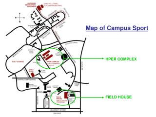
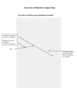
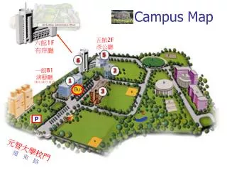
TPS CAmpus Map Publishing System Map Layout Design Choices • North is up • a.k.a. “phone-view” • UVM divided into 4 sub-campuses • Each is a separate map page • fully formatted (i.e. legend, title, etc.) • Formatted for printing • In Color, but designed for B/W printing • 8.5” x 11”
TPS CAmpus Map Publishing System Map Data Design • tblselectedpermit data temporarily establishes scope of deliverable by storing selected permit IDs • M-M tables permanently store relationships between permits and parking lots and buildings • tblpermit_parking • tblpermit_building
TPS CAmpus Map Publishing System Data Interfaces • Indexes • Create (“Add”) • Read (a.k.a. “Select”/”View”) • Update (“Edit”) • Delete
Future plans • Finished… • Maps by Permit Type (Resident-Blue, Employee-White) • Next?... • ESRI-to-Google Workflow • More Specific Use-cases • Present Project Results to Stakeholders • TPS • Campus Planning • ??? • Consider Project to Build Full System • Benefits • Customized Deliverables for Stakeholders • Revenue? • Costs • Support ü ü ü
Future plans • David Pepper davidpepperit@gmail.com • TeomanKorkmaz tqk5017@gmail.com