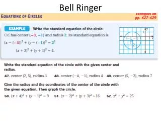
Bell Ringer
Bell Ringer. Take out a sheet of paper What are the three inalienable rights mention in the Declaration of Independence? Who wrote the Declaration of Independence? What year was the Declaration of Independence signed? What year was the Constitution ratified?

Bell Ringer
E N D
Presentation Transcript
Bell Ringer • Take out a sheet of paper • What are the three inalienable rights mention in the Declaration of Independence? • Who wrote the Declaration of Independence? • What year was the Declaration of Independence signed? • What year was the Constitution ratified? • Who was the first Constitutional President? Turn in
Maps 101 Latitude and Longitude
Hemispheres Northern Hemisphere Western Hemisphere Southern Hemisphere Eastern Hemisphere
Hemispheres The World is split by two lines. The Equator divides the Northern Hemisphere from the Southern Hemisphere.
Hemispheres The Prime Meridian divides the Eastern Hemisphere from the Western Hemisphere.
Global Position • Positions are given in reference to the Equator and the Prime Meridian. North America is in the Northern Hemisphere because it is North of the Equator Equator
Global Position Prime Meridian North America is in the Western Hemisphere because it is West of the Prime Meridian
1. Which continents are both in the Northern Hemisphere and Southern Hemisphere? 2. Which ocean is only in the Northern Hemisphere? 3. Is South America located in the Eastern or Western Hemisphere?
Global Position • What Hemisphere are these Continents? Country Equator Prime Meridian South America South West Canada North West Russia North East Australia South East Algeria North East North Korea North East Mexico North West
Latitude and Longitude On many maps and globes you can see lines crisscrossing with numbers by them. These lines and numbers are part of a grid system that allows us to describe the absolute location of any place.
Latitude • Lines running east and west around the Earth are called lines of Latitude, also called parallels (because parallel lines do not touch each other). • These lines use degrees to measure the distance north or southof the Equator0°.
Latitude Look at the globe on the right. Put your finger on the Equator at zero degrees (0°). On this globe the next line of latitude south is 15°S, then 30°S, then 45°S, and so on. 90°S is the farthest south you can go. What is the farthest North you can go?
Latitude When recording latitude you will report the number of degrees north or south of the Equator. Example: Cordoba is 38° N You must include the direction North or South. If the point you are locating is between two lines, then estimate its location to the nearest degree.
3. The strait of Gibraltar is a narrow body of water that separates the southern tip of Spain from Africa. At about what latitude is the strait located? 1. About how far north does Spain extend? Answer in terms of degrees latitude. 2. About what latitude is the capital city located?
Longitude • On a map or a globe the lines running north to south from pole to pole are called lines of longitude also call meridians. • Lines of longitude measure distance east or west of the Prime Meridian, which is 0°.
Look at the globe on the left. Put your finger on the Prime Meridian at zero degrees (0°). On this globe the next line of longitude east is 15°E, the first line of longitude west is 15°W. Unlike lines of latitude, lines of longitude eventually touch. Notice how the lines come together at the north and south pole.
Latitude When recording longitude you will report the number of degrees East or West of the Prime Meridian. Example: East London is 28°E
1. How far west does South Africa extend? How far east?2. At about what longitude is Cape Town located?3. At about what longitude is Durban located?
Latitude and Longitude Together lines of latitude and longitude form a grid called the coordinate system. Together the latitude and longitude make up a place’s coordinates Example: Atlanta is about 34°N, 84°W Find the Coordinates of the following Cities. 1. Savannah 2. Valdosta