Download
1 / 19
190 likes | 206 Views
This article explores the siting of industries in multi-hazard environments and provides insights into risk mapping and knowledge management. It discusses various aspects of disaster management, risk assessment, hazard reduction, and emergency response. The article emphasizes the need for a paradigm shift towards integrated, organized, and multi-hazard focused disaster risk reduction strategies.

E N D
SITING OF INDUSTRIES IN A MULTI-HAZARD ENVIRONMENTRisk Mapping and Knowledge Management Dr. Anil K. Gupta, Associate Professor Sreeja S. Nair, Assistant Professor National Institute of Disaster Management (Govt. of India, Ministry of Home Affairs) New Delhi
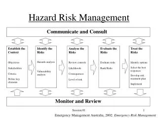
DISASTER MANAGEMENT VEHICLE RISK MANAGEMENT EMERGENCY RESPONSE Prevention Mitigation Preparedness Planning Planning Response Emergency Risk Assessment Hazard / Risk Reduction Vulnerability Reduction RESIDUAL RISK Risk Analysis Relief Governance ENVIRONMENT community COMMAND Rehabilitation Reconstruction Evaluation Monitoring Management centric Operation centric Disaster Risk Management
DM Paradigm Shift • Response Centric • Relief Centric • Mitigation centric • Preparedness centric • Disaster Centric • Hazard Centric • Vulnerability Centric • Environment Centric • From Relief to Risk Reduction • From Compartmental to Integration • From Ad-hoc to Organized • From Single hazard to multi-hazard Disaster Risk Reduction
MULT-HAZARD IMPACT ANALYSIS HAZARD RISK ANALYSIS MCAS & CONSEQUENCE ASSESSMENT SITE RISK ASSESSMENT HAZARD MITIGATION LAND-USE & ENVIRONMENTAL SETTING RISK INTEG RATION INTO DEVELOPMENT EMERGENCY PLANNING DISASTER MANAGEMENT STRATEGY PREPAREDNESS EMERGENCY RESPONSE & EVALUATION RESPONSE DRILL Site Assessment Functions
Development Planning and Disaster Risks • No development is sustainable if prone to disaster risks • Frequent diversity of eco-geo-physiographic features and cultural settings • Uniform development of Admin. units paradoxical – fails to recognize physical limits • Capacity of natural environment to absorb stresses limited • ‘Culture of Prevention’ and ‘Safe Development’ – key to DRR
Multi-Hazard Profile of India • 169 Districts of India Identified as Multi-hazard prone • Criteria considered 3 hazards i.e. Flood, Earthquake, Wind) –BMTPC 1997 • 241 Districts – BMTPC 2006 • considering 4 hazards i.e. Flood, Earthquake, Wind Hazards, Landslides)
Chemical Hazard Profile • Out of 602 districts in India, 263 districts have MAH units. • 170 districts have clusters of more than 05 MAH units (hazardous/industrial pockets). • Risk • There are 1666 MAH units in India.
Industrial Locations and Disasters • Hazardous chemicals • Fire / explosion, toxic release, radiation disasters • Heat / shock waves can cause damage to structures/housing • Environmental/ Natural triggers – can cause chemical accidents • Earthquake • Flooding • Landslides • Cyclone • Windstorm….. • Hazardous industrial wastes • HW (Secure) Landfill sites • Leaching / fire/explosion • Accidental / deliberate release of un-treated effluent • Bio-industries – pathogenic/infectious materials • Terrorist attack / sabotage / mass stampede
Chemical Disasters triggered by Natural Hazards • Orissa super cyclone in 1999 - Damage to phosphoric acid sludge containment during the Release of acrylonitrile at Kandla Port, during an earthquake in 2001 • Storms on December 1999 in France - damaged thermal power plant, nuclear plant and waste treatment plant • Earthquake in Kocaeli, Turkey in August 17, 1999 (magnitude 7.4) - triggered large fires, toxic air releases of dangerous substances and oil spills at several industrial facilities. • A dam broke at the Aurul Mine Tailings Recovery Plant near Baia Mare, 2000 - Industrial waste water with high cyanides concentration. A breach of about 25 m in the pond’s dam was produced. • Japan Earthquake (6.8-magnitude) July 16, 2007 - triggered fire at the seven-reactor, 8,212-megawatt Kashiwazaki-Kariwa nuclear power plant that burned a transformer, spilled several hundred barrels containing radioactive waste and vented radioactive waste. • Sichuan earthquake, August 30, 2008 - In the city of Shifang, the collapse of two chemical plants led to leakage of some 80 tons of liquid ammonia.
Mapping Chemical (Industrial) HazardsCurrent Scenario • GIS based Emergency Planning and Response System for Chemical Accidents in MAH Installations in Major Industrial Clusters' in four identified industrial states namely- Gujarat, Maharashtra, Tamil Nadu and Andhra Pradesh has been completed (MOEF-NIC). • This project extended to NCT of Delhi, Rajasthan, Uttar Pradesh, Haryana, Karnataka, Kerala, West Bengal, Assam, Madhya Pradesh and Punjab. • ERRIS prepared by the ICC Kolkata for the chemical units in Haldia and Durgapur in West Bengal (EU Funded) • No integrated database/maps of all the MAH units in India available. • Visualized ‘Industrial-chemical Disaster Risks’ in Isolation from multi-hazard framework
Siting Approaches • EIA – originally a site selection tool • Site clearance procedure (post selection appraisal) • Carrying capacity based planning process • Supportive Capacity • Assimilative Capacity • NCR, Doon valley, Jamshedpur, Satna… • 2010 BAU….Preferred Scenario, based projections • Regional EIA / Cumulative impacts • Zoning Atlas for Industrial Siting • GIS database / Atlas preparation • District level / inter-district conflicts and influences • Good initiative but Narrow approach • Better alternative? cost – time effective / holistic
Land-use & Site Selection Objectives • Economic and trade efficiency • Environmental compatibility • Minumum / minimised loss of earth resources - systems • Check in altering geo-morphological • Check in altering environmental (natural / man-made) resources • Check at causes of hazards: • Direct (industrial/chemical) • Indirect (geo-hydrological, climatic, biologic…) • Check at exposure and vulnerability: • Direct (industrial/chemical) • Indirect (geo-hydrological, climatic, biologic…) • Disaster Risk Reduction and Mitigation • Socio-cultural & Settlement Compatibility • Public Governance and coordination • Prompt / organized Response in Emergencies
Multi-hazard Risk MappingOperational Procedure for Site Categorization • Reference maps – base map, settlement map.. • Physical characteristics- land-use, geo-morphology, wastelands, drainage, major dams/irrigation, soil type, forests/forestry, agriculture use, seismicity, existing industrial use, mines/ minerals • Disaster history map • Projected disaster hotspots/zones • Geo-hydrological hazards • Hazardous installations and dumping • Ecological sensitivity and fragility • Pollution hotspots – critical areas • Meteorological patterns • Risk categorization & mapping (Environmental Micro-zonation) • Identification of suitable sites • Industrial use and waste disposal • New human settlements • Other land-uses (e.g. agriculture, forestry, etc.) • Region specific map for siting (in GIS environment) • Region-specific industrial siting guidelines
Data Needs and Sources • Hazard Maps of BMTPC, DST, NRSA data of IMD, CWC,GSI etc. • MoEF, State Department of Environment, Department of Factories and Boilers - SERs • Survey of India (update using high resolution satellite data or google maps) • Census of India • Data from line departments and NIC • CSO/NSSO data • National Soil Survey and Land-use Board • IMD /CWC/ NRSC data • Other sources (Statistical Hand book, Human Development reports, State Vulnerability Report. etc) • Administrative Maps • Data/ Maps of Natural Hazards • Chemical inventories - Data/ Maps of (Handling, Storage and transportation routes) • Geographic/Topographic data • Environmentally Sensitive Areas • Socio-economic data (highest possible resolution) • Infrastructure map with focus on Critical Infrastructure and emergency resources (fire, police, medical, civil defense, etc.) • Real time data on wind, temperature, humidity etc.
Government Community Industry Disaster risk managers Emergency Responders & Managers Insurance Sector Developers Cost / time effective and scientific inputs for siting decisions Reducing induced hazard events Reducing vulnerability Avoiding public movements and litigations Avoiding post-commissioning shifting Better and effective locating of resources for response Effective disaster Risk communication and Emergency communication Reduced load on emergency systems Liability reduction / premium savings Revisiting land-use surrounding hazardous units (in case industry already commissioned) Adopting appropriate mitigation strategies (structural and non structural) Post-commissioning risk monitoring and evaluation Benefits / Beneficiaries
Thank You envirosafe2007@gmail.com sreejanair22@gmail.com www.nidm.net