Exploring Roman Geography: From Alba Longa to Carthago
20 likes | 124 Views
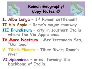
Delve into the ancient Roman landscape, from the first settlement at Alba Longa to the major roadway of Via Appia leading to Rome. Travel through Brundisium, where the Via Appia concludes, and explore Mare Nostrum, known as "Our Sea," the Mediterranean. The Tiber River, Rome's lifeline, winds through the region alongside the Apennines, the mountains shaping Italia's backbone. Discover the Pyrenees dividing Hispania from Gallia and the Alpes separating Italia from the rest of Europa. Learn about Hispania (Spain), Gallia (France), the Nile River (Nilus Flumen) in Aegyptus, and Carthago, Rome's formidable North African foe. Unravel the tapestry of Roman geography and its impact on the ancient world.

Exploring Roman Geography: From Alba Longa to Carthago
E N D
Presentation Transcript
Roman Geography!Copy Notes Alba Longa – 1st Roman settlement Via Appia– Rome’s major roadway Brundisium – city in southern Italia where the Via Appia ends Mare Nostrum – Mediterranean Sea; “Our Sea” TibrisFlumen– Tiber River; Rome’s river Apennines – mtns. forming the backbone of Italia
Roman Geography! Cont. VII. Pyrenees – (mtns.) separate Hispania from Gallia IIX. Alpes– (mtns.) separate Italia from the rest of Europa • Hispania – Spain • Gallia – France • NilusFlumen– Nile River (Aegyptus) • Carthago – N.African capital city; Rome’s great enemy