Geocoding
Geocoding. Lecture 19. What is Geocoding?. Geocoding is the process of assigning a coordinate to a description. For example, if you know the address of the San Diego Zoo is 2920 Zoo Dr., San Diego California 92101 Geocoding will use that description to assign a coordinate to the description:


Geocoding
E N D
Presentation Transcript
Geocoding Lecture 19
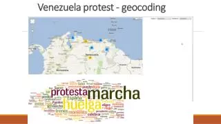
What is Geocoding? • Geocoding is the process of assigning a coordinate to a description. • For example, if you know the address of the San Diego Zoo is 2920 Zoo Dr., San Diego California 92101 • Geocoding will use that description to assign a coordinate to the description: • Lat 32.736869 • Long -117.148981
Common applications that use Geocoding • Mapquest • Google Earth • ESRI ArcExplorer Web • National Geographic Map Machine • Microsoft Streets and Trips • Microsoft Virtual Earth
Types of Geocoding • Input Geocoding • Single feature geocoding • Input an address • Returns a coordinate • Batch Geocoding • Automatic geocoding of a series of features • Input a table of addresses • Returns a shapefile • A spatially referenced database (Geodatabase)
Requirements • Reference Data • A database containing records representing the geometry of street segments between consecutive intersections and the address ranges on each side of each segment.
Address Table • A list of addresses that you want to input into GIS that are stored as a database table or a text file. • For Batch Geocoding • The address table format must match the reference data format. There are lots of reference data formats available.
Address Locator • A file that specifies • The reference data and it’s relevant attributes. • The relevant attributes from the address table. • Various geocoding rules and tolerances. • Different styles for reference data with different attributes. • For example: Is the house number and street name in one field or two? • Each style requires tat certain attributes be present in the address table as well.
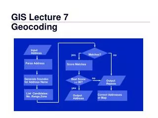
How it Works • Street segment record is located in the search. • The location along the segment is located. • The location is an estimate based on a linear interpolation of the range. • Assumptions: • The house numbers are sequential and in order • The addresses are spaced evenly along the street • The geographic coordinates of the point are returned.
To find the address 950 Broadway • The 900 block of Broadway is located in the reference data. • The even side of the street is identified. • Since 950 would be half way from 900 to 998, the estimate would be 50% of the line segment. 900 Block Broadway 998 900 901 999 Estimate
Example • Reference Data • San Diego County • Roads_All • Address Locator • ArcCatalog • Address Locator • Create new Address Locator • Choose Style • [File] - Shape file • [GDB] - Databse • US Streets with Zone [File]
Referenced Data - Shapefile being used • Roads_All • Bold items are required • From Left • LLowAddr • LHigAddr • To Right • RLowAddr • RHigAddr
Prefix Dir • RD20Pred • Prefix Type • Street Name • RD20Name • Street Type • RD20SFX • Left Zone • L_Zip • Right Zone • R_Zip
Input Address Fields • Field Containing • Zone • Delete - City • Add - L_Zip and R_Zip • For other fields, if you know of possible field names, they should be added here.
Test the Locator • ArcMap • Tools • Geocoding • Address Locator Manager • Add • Address Locator Folder • (Address Locator created in ArcCatalog) • Find Tool (Binoculars) • Address Tab • Type in address