Download

1 / 13
190 likes | 494 Views
Geocoding. Assigning Spatial Coordinates to Your Address Data. What is Geocoding?. Address Matching assigns Spatial Coordinates ( explicit location ) to Addresses ( implicit location ). Why Geocode?.

E N D
Geocoding Assigning Spatial Coordinates to Your Address Data Stacey Maples - stacey.maples@yale.edu Yale Map Collection / GIS Services - www.yale.edu/gis
What is Geocoding? Address Matchingassigns Spatial Coordinates (explicit location) to Addresses (implicit location)
Why Geocode? Geocoding of your address data allows it to be ‘overlaid’ with other explicitly spatial data for analysis. • U.S. Census Demographic Data • EPA Toxic Site Data • Landuse Maps • Proximity to Features of Interest Stacey Maples - stacey.maples@yale.edu Yale Map Collection / GIS Services - www.yale.edu/gis
Why Geocode? • Here we have geocoded the locations of Nursing Homes in Connecticut • From the locations of Hospitals we have created a map which describes the distance from the nearest Hospital at any given point in the state. • By ‘overlaying’ our geocoded nursing home locations on the ‘distance map’ we can create a new attribute for each of the nursing homes that describes its proximity to a hospital. Stacey Maples - stacey.maples@yale.edu Yale Map Collection / GIS Services - www.yale.edu/gis
Geocoding Requirements – Address Tables First… Address Matching requires a properly formatted Table of Addresses. • Abbreviations should be standardized and grammatical errors corrected. • When geocoding street addresses, data must include an address field with street number and name, and can include one or more of the following: • street prefix direction (“W. Redlands Blvd.”) • prefix type (“Avenue B”) • street type (“W. Redlands Blvd.”) • suffix direction (Park Ave. West.) • Street intersections may also be included in the address field. (Main St. & Ave A) Stacey Maples - stacey.maples@yale.edu Yale Map Collection / GIS Services - www.yale.edu/gis
Geocoding Requirements – Address Tables ArcMap Geocoding ‘Likes’ for your address information to be contained in a single field: Instead of This: Use This: Stacey Maples - stacey.maples@yale.edu Yale Map Collection / GIS Services - www.yale.edu/gis
Geocoding Requirements – Reference Data Second… Address matching requires a Street Network File with street attribute information (street name and number range for each block) for all street segments (block sides) • precise matching of street names can be problematic • completeness (esp. for ‘new’ streets) important • PO boxes, building names, and apartment complex names cause problems. In most cases, the Street Network File for the U.S. is some variant of the Topologically Integrated Geographic Encoding and Referencing (TIGER) files produced by the U.S. Census Bureau. Stacey Maples - stacey.maples@yale.edu Yale Map Collection / GIS Services - www.yale.edu/gis
Topologically Integrated Geographic Encoding and Referencing (TIGER) • The TIGER/Line files provide information on streets, rivers, railroads, and other line features, where they intersect and the areas they enclose, in a form that can be processed by a computer. They were created by the U.S. Census Bureau for use in Census Data Collection.TIGER/Line records contain: • codes identifying census geographic areas • address ranges and ZIP Codes. Stacey Maples - stacey.maples@yale.edu Yale Map Collection / GIS Services - www.yale.edu/gis
How TIGER Handles Topology • FNODE/TNODE: • From Node / To Node • Establish Directionality • FRADDL/TOADDL & FRADDR/FRADDL: • From Address / To Address for each side of Street Feature • Establishes the Address Range for each Line Segment in the TIGER Line File. Stacey Maples - stacey.maples@yale.edu Yale Map Collection / GIS Services - www.yale.edu/gis
How Geocoding Places Points on the TIGER Line Files Given the Address: 75 New Lebbon Rd The Geocoding Process will find the record shown below within the TIGER reference file. With the Street Number being odd, the process will place the Geocoded Point along this line feature, and relative to the address range 57-99. 75-57/99-57=18/42=.42 So that the Geocoded point for 75 New Lebbon Rd. is placed 42% along the given length for this segment of New Lebbon Rd. Stacey Maples - stacey.maples@yale.edu Yale Map Collection / GIS Services - www.yale.edu/gis
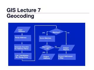
Geocoding Requirements – Continued… Third and Finally… Address Matching requires an Address Locator which establishes explicit methods for matching (geocoding) address data to specified reference data based on guidelines unique to the locator style selected and any customizations. • A “geocoding index” is created which, rather than the entire reference table, is used to quickly match addresses when geocoding. • Guides for reference data type and how it will be related to the address data by the software. • Interface for specifying Geocoding Options (Offset, Acceptable Match Scores, etc…) Stacey Maples - stacey.maples@yale.edu Yale Map Collection / GIS Services - www.yale.edu/gis
Why Offsets are Necessary In many cases, you will be interested in using your geocoded data with Census data. Consider the following: • Census uses the TIGER line files streets, in most cases, as the boundary for its geographic units (tracts, block groups, blocks). • When you use the TIGER line files streets for geocoding you addresses, your resulting points are placed upon the street segment. • So if your address point lies upon the Census boundary, which Census Block is it in? • ArcMap doesn’t know either! If you have multiple incidents at the same address, ArcMap with essentially ‘flip a coin’ for each incident to assign it to one side of the line, or the other. The answer is to assign an offset to your geocoding results. 5-10 ft. is usually sufficient for the purpose of overlay. Stacey Maples - stacey.maples@yale.edu Yale Map Collection / GIS Services - www.yale.edu/gis
What You End Up With • Status • U - Unmatched • M - Matched • T – Tied with other locations • Score – The 0-100 score with which the address was matched. • Side – The side of the street that the address falls upon. • X,Y – the Longitude/Latitude coordinates of the address. • Stan_addr – The address as the computer prefers it. • Pct_along – Where along the street segment length the point was placed. • The remainder of the fields are those contained in your original address data file. Stacey Maples - stacey.maples@yale.edu Yale Map Collection / GIS Services - www.yale.edu/gis