Download
1 / 25
250 likes | 344 Views
Explore the São Joaquim National Park, a protected area in the Atlantic Rainforest. Visit Morro da Igreja, waterfalls, and canyons. Encounter diverse ecosystems and the park's highest peak. Enjoy breathtaking scenery and rich biodiversity.

E N D
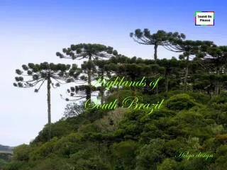
Highlands ofSouth Brazil Helga design
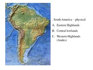
São Joaquim National ParkThe São Joaquim Nacional Park is an IntegralProtection Conservation Unit of the Mata Atlântica Biosphere Reserve in the state of Santa Catarina. It is located 12 km south of Urubici and 170 km southwest of Florianópolis. Similar to the national parks of AparadosdaSerra and Serra Geral further in the south, São Joaquim protects 49.000 ha of the ecosystems mixed tropical rainforest (floresta ombrófila mista or araucária) and altitude fields of the Atlantic Rainforest / (Mata Atlântica) biome which occur above the canyons and highlands of the SerraGeral Formation in this part of the Paraná Basin. At the peak of Morro da Igreja (1.822 m), the park´s highest point, the lowest temperatures of Brazil (- 17,5° C) have been measured. The main ecotouristic attractions of the park (and surroundings) are: the mountains / hills Morro da Igreja (Pedra Furada) and Campestre, the waterfalls Avencal, Véu da Noiva, Dos Bugres, Sete Quedas and canyons
Parque Nacional de São JoaquimO Parque Nacional de São Joaquim é uma Unidade de Conservação brasileira e está situado na região sul, no estado de Santa Catarina próximo à cidade de São Joaquim, com aréa de abrangência dentro dos municípios de Urubici e Bom Jardim da Serra. Foi criado em 06/07/61 pelo decreto N. 50.922. A área total do Parque é 49.300 ha. Na região nordeste do parque encontram-se as maiores altitudes, sendo o ponto máximo o Morro do Igreja, com 1822 metros. Também, no centro do parque, há áreas bastante elevedas, com altitudes acima de 1650 metros. Essa região do parque é denominada Campos de Santa Bárbara. As rochas que formam o embasamento do parque rochas vulcânicas, denominadas basalto, e datam de 133 milhões de anos.As temperaturas podem chegar a -16graus centígrados
Music : Ode of Joy Helga June 2008