Parent Material
Parent Material. #1. Weathered bedrock. Very Rare in Northern Indiana. Parent Material. #1. Till. default: if nothing else fits. judged deep in pit. Parent Material. #1. Outwash. step 2 from water. courser under finer subsoil. Parent Material. #1. Eolian Sand.

Parent Material
E N D
Presentation Transcript
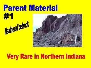
Parent Material #1 Weathered bedrock Very Rare in Northern Indiana
Parent Material #1 Till default: if nothing else fits judged deep in pit
Parent Material #1 Outwash step 2 from water courser under finer subsoil
Parent Material #1 Eolian Sand pure sand over pure sand Falls out throughout pit no pebbles judged throughout pit
Parent Material #1 Loess medium surface texture (silt) no pebbles judged high in pit
Parent Material #1 Alluvium Next to water organic material Medium over Medium
Parent Material #1 Local Overwash Bottom of hill > 20" thick buries a dark horizon judged high in pit
Slope #2 Use clinometer 0-2% Pretty level small hill 3-6% medium hill 7-12% 13-18% large hill 19-25% XL hill (steep) 26-35% Supersize hill >35% ravine
Landform #3 Till, Loess, or flat Eolian Sand Parent material Upland > 3% slope hillslope swell <2%, convex water runs away depr/flat <2%, 3 sides higher
Landform #3 Dune Eolian sand Parent material > 3% slope
Landform #3 Filled Depression Local Overwash Parent material
Landform #3 Outwash Parent material Outwash > 3% slope hillslope swell <2%, convex water runs away depr/flat <2%, 3 sides higher
Landform #3 Floodplain Alluvium Parent material
Color, Surface #4 Use Munsell 10yr color chart Wet down soil Judge 2" below surface
Erosion #5 None to slight >6" of topsoil Moderate 2-6" of topsoil Severe <2" of topsoil
Texture #6&7 (surface & subsoil)
Texture #6&7 (surface & subsoil) Sandy will not ribbon Moderately Sandy ribbons <1/2" Medium ribbons 1/2-1&1/2" Moderately Clayey long ribbon, dull Clayey long ribbon, shiney
Natural Drainage Diagnostic zone: dark surface judge 6" below dark surface brown/gray srface judge 10-18" below top of pit
Natural Drainage #8 Poorly Mostly gray diagnostic zone Somewhat poorly NDDZ Gray suit with brown spots NDDZ Brown suit with gray spots Moderately well Little gray <30" well
Limiting Layer #9 Limiting layersMust be at leats 10" thick or continue to bottom of pit Bedrock Limestone in Indiana
Limiting Layer #9 Dense till Associated with calcareous deposits No plant roots present >1.75 g/cm3
Limiting Layer #9 Fragipan Not in Northern Indiana
Limiting Layer #9 Course Sand & Gravel (CS&G) large sand or gravelly falls out at bottom
Limiting Layer #9 None within 40" nothing that qualifies as a limiting layer
Current land use Naturally vegetated land forest, prairie, marsh, abanded fields with invading trees
Current land use Agricultural or developed land cropland, pasture, field borders, conservation reserves, developed land
Agriclture & Environmental Practices
Prime Farmland #51 Yes If: no pure sand in subsoil and >20" to bedrock or CS&G and <6% slope
Soil & Water Degradation #52 high potential Yes If: soil erosion by water >2% slope and < 20" to limiting layer or >6% slope
Soil & Water Degradation #53 high potential Yes If: soil erosion by wind sand on top
Soil & Water Degradation #54 high potential Yes If: soil compaction wet and without pure sand
Soil & Water Degradation #55 high potential Yes If: groundwater pollution wet and sandy subsoil CS&G or
Soil & Water Degradation #56 high potential Yes If: surface water pollution >6% slope
Vegetation and buffer practices #57 Yes If: natural vegetation always
Vegetation and buffer practices #58 Yes If: Grassed waterways 3 - 18% slope
Vegetation and buffer practices #59 Yes If: windbreaks Sand on top
Vegetation and buffer practices #60 Yes If: Filter strips <18% slope and poorly drained outwash floodplain or or
Tillage and Cropping practices #61 Yes If: permanant pasture <25% slope
Tillage and Cropping practices #62 Yes If: Crop Rotation <18% slope
Tillage and Cropping practices #63 Yes If: No-till with cover crop <12% slope and dry sand on top or
Tillage and Cropping practices #64 Yes If: No-till <6% slope and dry wet without pure clay on top or
Tillage and Cropping practices #65 Yes If: clean tillage <2% slope and and NO Sand on top wet
Water Management practices #66 Yes If: preserve as wetland Naturally vegetated and Poor drainage wet floodplain or
Water Management practices #67 Yes If: artificial drainage farmland/developed and not a floodplain wet and
Water Management practices #68 Yes If: irrigation <6% slope and sand in subsoil CS&G or
Water Management practices #69 Yes If: parallel terraces not poorly drained deep and and no sand in subsoil 3 - 12% slope and
Chemical & Fertility practices #70 High If: Nitrogen application deep and and no sand wet and dark surface
Chemical & Fertility practices #70 Medium If: Nitrogen application >20" to limiting layer and and no pure sand <12% slope anything else Low If:
Chemical & Fertility practices #71 Apply If: P: Phosphorus < 30 lbs/ac Deplete If: > 200 lbs/ac
Chemical & Fertility practices #72 Apply If: K: Potassium < 210 lbs/ac Deplete If: > 500 lbs/ac