Download
1 / 13
130 likes | 145 Views
This paper focuses on establishing the variation of main elements of flood waves with the surface, including maximum discharge, rise duration, decrease duration, and depth of runoff. The study is based on data from the Moneasa representative basin, specifically the Moneasa River which is a tributary of the Sebis River. The methodology used includes genetic analysis and statistical methods. The results show relationships between variables such as maximum discharge and rainfall intensity, rise duration and rainfall duration, decrease duration and total rainfall duration, and depth of runoff and precipitation quantity. The study provides valuable insights into the variation of flood wave elements with surface characteristics.

E N D
Results Regarding Variation Of The Main Elements Of Flood Waves With The Surface Adrian VLADUCU National Institute of Hydrology and Water Management Bucharest, ROMANIA
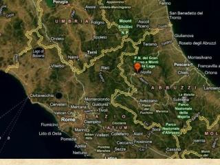
INTRODUCTION Objective of the paper Establishing the variation with the surface of the flood wave main elements: - maximum discharge (mc/s) - rise duration (min) - decrease duration (min) - depth of runoff (mm) Used database Data that were at the basis of the elaboration of this paper belong to the Moneasa representative basin. I emphasize that the Moneasa River is the tributary of the Sebis River, which belongs to the Crisul Alb River basin
The use of the data from this basin was due to the existence of no more than 7 gauging stations to which correspond basin surfaces which vary from 0.146 kmp to 76.2 kmp Gauging stations from Moneasa river basin
METHODOLOGY • The main method was the genetic one, that is, all flood wave elements were analyzed in dependency with the characteristics of precipitations – quantity, duration, intensity. • The first step in the analysis was the getting of such relations within each sub-basin, characterized by a certain surface. • The next step was the establishment of the variation of the elements of flood waves with the surface, in the case of certain types of precipitations. • We must emphasize that also the statistical method was used, but to a small extent, in determining some elements of the flood elements, for the comparison of results.
The scheme with the main characteristics of the flood wave • Tt – total duration of rainfall • tp – the time interval between the starting point of the flood and the end of the rain nucleus • t1+t2 – the time interval from the beginning of the rainfall until the beginning of the flood • Xt, xp, x1 – precipitations fallen in Tt, tp and t1 intervals • tcr, td, Tv – increase time, decrease time and total time of the flood • Qmax – maximum discharge of the flood • Qi, Qf – initial discharge, respectively the end of the flood
RESULTS In the case of the MAXIMUM DISCHARGE Qmax = f (ip,tp) for Ruja hydrometric station There were obtained relations between the maximum discharge of the floods, Qmax (mc/s) and rainfall intensity, ip (mm/min) correspondent to the tp interval; Qmax = f (ip,tp). From the relation presented in figure, for Ruja hydrometric station (S=6.60 kmp) it is noticed that at equal values of the ip (mm/min), the value of the discharge increases as the tp interval increases. In the case of the Ruja hydrometric station, at an intensity ip = 1.20 mm/min, for example, the discharge has maximum values in the case of durations tp = 60-70 min.
Variation of the maximum discharge of 1% probability with the surface In order to establish the variation of the maximum discharge with the surface there were used the values of the specific maximum discharge values with a probability of 1% (qmax1%), determined through the mentioned method and verified with the statistical model. RUJA BOROAIA RANUSA 1 MONEASA RANUSA 2 qmax1% - S relation
In the case of RISE DURATION OF THE FLOOD The study showed that the rise duration of the flood (tcr), mostly depends (in the case of a small river basin) on the duration of the rainfall from the interval at the beginning of the flood until the end of the rainfall nucleus (tp). 180 150 120 90 60 tcr=f (S) for different time durations tp
In the case of the DECREASE DURATION OF THE FLOOD From the multitude of relations made between the decrease duration (td) and certain characteristics of rain, the most significant resulted to be between the decrease duration of the flood and the total duration of the rainfall Tt in which the quantity of fallen precipitations is also taken into account, Xt in Tt interval. Xt = 60 mm Tt The relation td=f (S) for certain values of Tt, in the case of a precipitation quantity Xt=60mm, from which the increase with the surface of this element of the flood wave is emphasized.
In the case of the DEPTH OF RUNOFF (hs=W/S) • The depth of runoff (hs), was analyzed in dependency of the precipitation quantity that generated the flash flood, xp, taking into account the precipitations fallen 10 days before (API10). The relations emphasized the increase of hs values as the values of the xp and API10 increased. • hs = f (S) relations were obtained for certain precipitation quantities, the same for all hydrometric stations • hs1% values from the hydrometric station were determined based on tcr, td, Qmax values, which were determined in their turn for the 1% probability (Method 1) and in the case of the annual maximum layers analysis, correspondent to the floods with the greatest volume in that year, whatever the value of the discharge (Method 2). • The difference between the values of the depth of runoff 1% probability, obtained through the two methods is also emphasized in the charts in figure , where it presents the variation of the depth of runoff for the entire surface, analyzed within the Moneasa river basin, from 6.60 kmp to 76.2 kmp.
For the Ranusa hydrometric station (S=76.2 kmp) the hs1% value was 67.6 mm through method 1 and 102.3 mm through the hs annual maximum, method 2. hs = f (S) relations S (km2)
CONCLUSIONS • A correct method of determination of flood wave elements was used taking into account mainly the characteristics of the genetic factor – precipitations. • The statistical method was still used in order to compare the results obtained through the two methods • The obtained syntheses have a great practical utility, disposing of precise data of the flood wave elements for a surface variation of up to 100 kmp. These can be used also for other areas of the country, which have the same characteristics of the factors of the natural framework as the Moneasa river basin. • The getting of the 1% probability depth of runoff through several methods is useful in the design field, which can choose for one of the resulted values, considered to be adequate to the specific and importance of a certain work.