Download
1 / 4
50 likes | 715 Views
Latitude and Longitude. VAV 2004. Latitude lines run across the map measured in degrees north and south of the Equator they are parallel decrease in length towards the Poles. Longitude lines run up and down the map measured in degrees east and west of the Greenwich Meridian

E N D
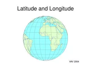
Latitude and Longitude VAV 2004
Latitude lines run across the map measured in degrees north and south of the Equator they are parallel decrease in length towards the Poles Longitude lines run up and down the map measured in degrees east and west of the Greenwich Meridian they converge at the Poles they are all the same length Latitude and Longitude….
Time goes behind Time goes ahead West 0º East 180º North Sun does not rise on 21 Dec 66½º Arctic Circle Tropic of Cancer Sun overhead 21 June 23½º Equator 0º Sun overhead 21 December 23½º Tropic of Capricorn International Date Line Greenwich Meridian Antarctic Circle Sun does not rise on 21 June 66½º South