Download
1 / 26
260 likes | 279 Views
Dive into a geographical adventure learning about diverse landscapes and mapping tools like latitude and longitude lines. Discover famous landmarks like the Himalayas and the Amazon River while unraveling the forces shaping our world.

E N D
Geography Map Exercise 1 Solutions
Matching • Polaris • The North Star • 90oS Lat • South Pole • Gobi • Large desert in Northern China • Nile • Longest river in the world
Matching • Andes • Longest mountain range on Earth • Japan • Land of the rising sun • Continental • All of the US except Alaska and Hawaii • Everest • Tallest mountain on Earth
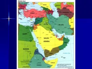
Continents & Oceans • Atlantic • Indian • Pacific Use the link below to practice finding the continents and oceans • Asia • Africa • North America • Australia • South America • Europe • Antarctica http://www.lizardpoint.com/fun/geoquiz/worldquiz.html
Tropic of Cancer (North), Tropic of Capricorn (South) 23O 26’ from the equator (Earth’s tilt) Direct sunlight only hits the Earth between these latitude lines
Tropic of Cancer Tropic of Capricorn 23O 26’ from the equator In Unit 2 “Force that Shape our World” we will learn more about the Earth’s tilt, how it creates our seasons, and the significance of the Tropics.
MesoamericaCentral Mexico and South Mexico through Central America, including Guatemala, Belize, Honduras, and El Salvador.Sometimes Nicaragua, and Northern Costa Rica are included.
Latitude linesRun East to West Parallel to the EquatorMeasures degrees North or South of the Equator
Longitude linesRun North to South fromNorth Pole to South Pole.Measures degrees East or West of the Prime Meridian.
Developing Mental Maps • What do you visualize when someone says desert? • What mental images do you associate with this geographic region?
Forces that Shape our Earth • The Himalaya and Andes Mountains are being created (yes they are still “growing”) by the movement of tectonic plates.
Forces that shape our Earth • The Andes Mountains are part of the “Ring of Fire.” This region of the world has a high level of geographic instability due to the collision of the Earth’s tectonic plates.