Southern Surveyor
40 likes | 204 Views
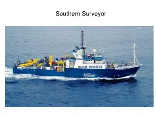
Southern Surveyor. Instruments on the Southern Surveyor Radiosondes PNNL Atmospheric Remote Sensing Laboratory (PARSL) Surface Fluxes Sea Surface Temperature Marine – Atmospheric Emitted Radiance Interferometer (M-AERI) Atmospheric state Oceanographic profiles.

Southern Surveyor
E N D
Presentation Transcript
Instruments on the Southern Surveyor Radiosondes PNNL Atmospheric Remote Sensing Laboratory (PARSL) Surface Fluxes Sea Surface Temperature Marine – Atmospheric Emitted Radiance Interferometer (M-AERI) Atmospheric state Oceanographic profiles
PNNL Atmospheric Remote Sensing Laboratory (PARSL) 94 GHz radar 532 nm lidar (dual polarization) Microwave radiometer (23, 35 GHz) Ceilometer (7 km max range) Infrared Thermometer (9-11 micrometers) Optical Rain Gauge Temperature/Humidity
Brookhaven National Laboratory 2 Portable Radiation Packages – solar and IR radiation Bulk flux measurements ISAR – IR measurement of sea surface temperature Total Sky Imager (with PNNL) Sea Snake, towed SST sensor CSIRO Flux measurement package 3 optical rain gauges Seasoar with CTD (conductivity, temperature, depth) Flinders University 3 shallow moorings with current, SeaCats (conductivity, temperature) U. Miami Marine – Atmospheric Emitted Radiance Interferometer (M-AERI)