Download
1 / 4
40 likes | 163 Views
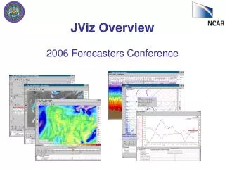
JViz Overview 2006 Forecasters Conference. What is JViz?. 2-D display (Java) application for 4dwx. Intuitive, interactive user-interface. Configured for each range. Access via display node (vmet) and webstart. JViz’s Data Sets. RTFDDA Model Data. GOES Satellite Data. NAM data.

E N D
What is JViz? • 2-D display (Java) application for 4dwx. • Intuitive, interactive user-interface. • Configured for each range. • Access via display node (vmet) and webstart.
JViz’s Data Sets RTFDDA Model Data. GOES Satellite Data. NAM data. Radar data (1 chosen for each range). SAMS, Mesowest and WMO metars, Lightning. Soundings. Profilers. GIS-like data.
JViz’s Viz Products 2D maps. Vertical cross-sections. SkewT plots. Time-series plots. Time-height (meteogram) plots. Tables.