Meso-Analysis Project
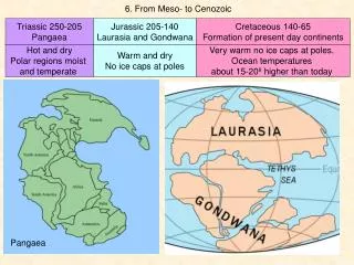
Meso-Analysis Project. Towards a Gridded Integrated Approache for Nowcasting. Great Lakes Operational Meteorology Workshop April 2013. P. Bourgouin, C. Landry , J.-F. Desch ê nes, J. Marcoux, D. Talbot, M. Verville. Meteorological Systems Section Canadian Meteorological Centre

Meso-Analysis Project
E N D
Presentation Transcript
Meso-Analysis Project Towards a Gridded Integrated Approache for Nowcasting ... Great Lakes Operational Meteorology Workshop April 2013 P. Bourgouin, C. Landry, J.-F. Deschênes, J. Marcoux, D. Talbot, M. Verville Meteorological Systems Section Canadian Meteorological Centre Meteorological Service of Canada Dorval, Québec, Canada
Overview • Introduction • The context • Prototype description • Future development
1. Introduction • There is a need for a gridded nowcasting prediction system to support the public, marine and aviation forecast programs. • Some of the requirements: • real time observations and nowcasting weather elements on a grid • deterministic or probabilistic weather elements • optimum use of all types of observations • high resolution (temporal, grid) • reliable and totally automated • optimum interpolation techniques • efficient extrapolation techniques • high resolution model • weighted variable approach as a function of forecast time
2. The context • MSC operates a point based nowcasting system called : Integrated NowCasting System (INCS) • INCS supports Scribethe forecast production tool used to prepare Public, Marine & Air Quality forecasts. • INCS provides weather elements only for the Public program • MSC is currently working on planning the Next Generation Forecast System (Concept of Operation: ConOps) and a gridded weather elements approach is envisioned • A Meso-scale Analysis and Nowcasting prototype has been developped by Pierre Bourgouin • An event base extrapolation technique is needed to improve two nowcasting statistical modules: TAFTools & PubTools
Scribe: Point based Forecast production tool National Production CMC SPC Wx Office + … Products Generator Concepts Generator Matrices Generator MODELS & other data sources PRODUCTS MATRICES Weather Elements Scribe Interface Observations METAR, Radar Lightning Nowcasting • Nowcasting • Hourly • MATRICES Updated Weather Elements Very short range Forecast System Rules NWP - UMOS
3. Prototype description • Observations from surface stations are converted into analyses using the Kriging interpolation method (50 km grid): • Extraction of hourly surface observations over Canada (all), northern US (selection) and western Greenland (selection) • Transformation of the different elements (TT, ET, TD, VS, UU, VV, VIT, PN, VE, HB, INT, TYP, CVC, CL, PLF, TOB, OPA, ECI, ZR) into analyses at a 50-km resolution using Kriging • Consistency check using a rule-based module • Resulting first-guess meso-scale analysis are done forprecipitation types (occurrence), convection and cloud cover • These preliminary analysis are then improve by using data from other sources: • Precipitation type analysis is refined using data from radar, satellite, NWP model (Côté et al. 1998). • Convection analysis uses the Canadian lightning detector network (Orville et al. 2002) and NWP model. • Cloud cover analysis is improved using a mid-level cloud analysis produced using GOES satellite data (Garand 1993).
The sequence in the production of the meso-scale analysis is important: • Cloud cover • Precipitation occurrences • Precipitation types ( Convective analysis is independent) • The final analysis are extrapolated by a forward scheme using the NWP wind field (50% of 500 hPa or 100% 700 hPa)
1. Cloud cover • Coast + oceans : AVG [SAT + RDPS + TRIAL + Interpol.] • Continent : AVG [SAT + TRIAL + 2*Interpol.]
SAT – CF KRIGING CLOUD COVER ANALYSIS TRIAL: NC ET T+1H RDPS - NT
2. Precipitation occurrence • Produce by combining the following information: • model data (over ocean & lakes) • radars composite • integrated cloud analysis (sfc obs + sattelite + model) • interpolated precipitation occurrence analysis (sfc obs + Kriging) • one hour forecast of precipitiation occurrence (trial field) • A weight is given to each value. If the sommation of the weighted values exceeds a threshold, precipitation are diagnose at this grid point.
PRECIP. OCC. ANALYSIS RDPS - Amounts RADAR KRIGGING OCC. Cloud Cover TRIAL OCC T+1H
INITIAL PRECIPITATION ANALYSIS (COLOR) AND NWP PRECIPITATION (BLUE)
FINAL PRECIPITATION ANALYSIS (COLOR) AND OBSERVATIONS (RED)
3. Precipitation Type • Produced by combining the following information: • Interpolated types analysis (Kriging) • Final Precipitations occurrences analysis • RDPS model type analysis • Diagnostics temperature • If precipitation occurrence is diagnosed at a point, the type associoated will be selected from the first non “nil” of: • Result of the Kriging analysis at that point • Near by analysis • Model diagnostic • rain if T > 3o C, otherwise snow • Type = “nil” Types are: • No precip • Liquid • Solid • Fresing
Interp. TYP + OCC SOL FRZG RDPS TYP LIQ PRECIPITATION TYPES ANALYSIS SUMMER CASE Temperatures
PRECIPITATION TYPES ANALYSIS WINTER CASE 20060222 1500UTC
4. Convection • Produced by combining the following information: • Interpolation analysis of convection (Kriging) • Lightning data • Lifted index from RDPS (only for showers) Types are: • Stable • CU • TCU/ACC • CB
SHOWER TYPE CUMULUS TYPE THUNDERSTORM TYPE CONVECTION ANALYSIS (COLOR) AND OBSERVATIONS (BLUE)
5. Extrapolation • Extrapolation module using NWP wind fields to advect precipitation type, convection and cloud cover. • Current version uses 50% of 500 hPa RDPS winds.
ADVECTION USING 50% OF THE 500hPa WIND FROM A NWP MODEL PRECIPITATION TYPE ANALYSIS (BLUE CONT.) AND FORECAST AT T+01H (COLOR)
ADVECTION USING 50% OF THE 500hPa WIND FROM A NWP MODEL PRECIPITATION TYPE ANALYSIS (BLUE) PRECIPITATION TYPE T+03H (MAGENTA) CONVECTION T+03H (RED Contours)
00:00 UTC 12-04-2013 23:00 UTC 11-04-2013 21:00 UTC 11-04-2013 22:00 UTC 11-04-2013 01:00 UTC 12-04-2013 20:00 UTC 11-04-2013 Nowcasting module Precipitation types, Convection & Clouds Meso-Scale Analysis Precipitation Types
Verification • This evaluation was performed over two periods: a warm season April to September and a cold season November to March. • The occurrence of precipitations was verified for the values produced by: • Meso-Analysis extrapolated (Sampling) • 00Z and 12Z run RDPS (Sampling) • PubTools (Nowcasting statistical forecast system bases on METAR) • Scores • RPSS (Ranked Probability Skill Score) • HSS (Heidky Skill Score) • PC (Percent Correct)
Warm Season (April to September) 00 & 12UTC Crossing ~To + 4h
4- Future of development • Finalise the « operationability » of system (Ops. Standards) • Increase resolution to current Regional Model (10km) • Evaluate possible replacement of the Kriging method with the optimal interpolation scheme MIST (Moteur d'Interpolation Statistique : Statistical Interpolation Engine) • Verify forecasts produced with the extrapolation technique and with INCS outputs. • Integrate the Meso-scale Analysis & Extrapolation into INCS • Compare extrapolation with motion vectors from MAPLE (McGill Algorithm for Precipitation Lagrangien Advection, Turner et Al. 2004) with the winds of Canadian Regional NWP model (RDPS) • Define the best way of choosing the appropriate wind field level for the extrapolation • Explore a vertical differential extrapolation approach based on more than one level (Ex. low, mid and high levels)
Thank you Merci Questions ?