Download

1 / 55
560 likes | 729 Views
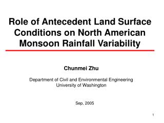
Spatio-Temporal Variability of the North American Monsoon. Balaji Rajagopalan Department of Civil, Env. And Arch. Engineering (CEAE) and CIRES Katrina Grantz , Edie Zagona CEAE/CADSWES & Martyn Clark (CIRES). Introduction. North American Monsoon

E N D
Spatio-Temporal Variability of the North American Monsoon Balaji Rajagopalan Department of Civil, Env. And Arch. Engineering (CEAE) and CIRES Katrina Grantz, Edie Zagona CEAE/CADSWES & Martyn Clark (CIRES)
Introduction • North American Monsoon • Dramatic increase in rainfall from an extremely dry June to a rainy July, August and September • SW United States and NW Mexico • Shift in winds (from westerlies to southerlies) brings moisture over the land • Warm land + moisture = monsoonal precipitation • Afternoon thunderstorms
Jan Jun Dec Jan Jun Dec Introduction • Significant portion (30-50%) of annual precipitation falls in the summer months in Arizona and New Mexico • Water management perspective: important to predict the strength of the monsoon • for water supply and environmental planning • Few studies on timing, streamflow, and implications for water management • important to local communities in the monsoon region
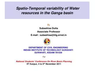
North American Monsoon Experiment Schematic Schematic Illustrating the multi-tiered approach of the North American Monsoon Experiment (NAME). The schematic also shows mean (July-September 1979-1995) 925-hPa vector wind and merged satellite estimates and raingauge observations of precipitation (shading) in millimeters.
North American Monsoon Schematic
Past Studies • Spatial and temporal variability depends on: • Location of subtropical jet, topography, SSTs … • Moisture comes from Gulf of California and Gulf of Mexico • Wet winter Early monsoon onset and vice-versa (Higgins & Shi, 2000) • General negative correlation with previous winter’s precipitation(Gutzler, 2002; Higgins & Shi, 2000) – related to North Pacific SSTs • El Nino weaker/southward monsoon ridge (Castro, 2000) • Increasedmonsoonal precipitation with increased soil moisture (Toshi, et al. 2003; Small,2000)
Past StudiesHiggins et al. 1998 Composite evolution of the 30-day running mean area average precipitation (units: mm/day) over Arizona and New Mexico for wet monsoons (dotted line), dry monsoons (dot-dashed line) and all (1963-94) monsoons (solid line). The average date of monsoon onset is July 1 for wet monsoons, July 11 for dry monsoons and July 7 for all monsoons (defined as day 0 in each case).
Days Vs. Elevation (m) Earlier Flow (#days) Later Flows (#days) 50% annual flow of water year Regonda, S., B. Rajagopalan, M. Clark, and J. Pitlick, 2005: Seasonal cycle shifts in hydroclimatology over the Western US, Journal of Climate. MotivationSeasonal cycle shifts in Western US hydroclimatology (Regonda et al. 2005)
April 1 SWE (cm) Temp. spell (Days) Annual flows (100 cfs) Winter Precip. (cm) Decrease in quantity Increase in quantity Cont’d
Motivation • What are the large-scale Ocean/Atmospheric/Land drivers of space-time (timing and amount) variability of N. American Monsoon (interannual / decadal)? • Potential Long-lead Precitability? • Implications for water management. • Need a systematic investigation of the monsoon rainfall attributes and also the streamflows.
Outline • Study area, data • The research project • Precipitation diagnostics • Streamflow diagnostics (preliminary results) • Water management issues • Incorporating forecasts into water management
Study Area • Monsoon Region (NAME II): Arizona and New Mexico • Water Management: Gila River • Flows from New Mexico through Arizona, joins Colorado River at Yuma, Arizona AZ NM
Data • Precipitation • Monthly climate division data (1948-2004) • NM (8 divisions), AZ (7 divisions) • Daily NWS co-op data (1948-1999) • 219 stations across AZ and NM • Temperature, PDSI • Monthly climate division data (1948-2004) • Large-scale climate variables • Monthly NOAA NCEP-NCAR reanalysis data (1948-2004) • SST, precipitable water, geopotential heights, vector winds • Streamflow • Daily HCDN streamflow (1948-1999) • USGS daily/monthly values (1948-2005) Co-op Stations
The Research Project • Precipitation diagnostics • Streamflow diagnostics • Water management issues • Incorporating forecasts into water management
Precipitation Diagnostics • Monsoon cycle • Monsoon rainfall • Plausible hypothesis • Antecedent land conditions • Antecedent ocean & Atmospheric conditions
Precipitation Diagnostics:Monsoon Cycle • Monsoon ‘timing’ at each co-op station • Calculate Julian day when 10, 25, 50, 75, and 90th percentile of the monsoon season (July-Sept) precipitation has fallen (each station, each year) -- Julian day time series for each threshold for each station • Perform trend analysis on the Julian day time series • 10th, 25th, 50th, 75th, and 90th percentiles capture the entire ‘monsoon cycle’ – onset, peak and recedence
Precipitation Diagnostics:Monsoon Cycle • Use Spearman rank correlation to detect trends A nonparametric (distribution-free) correlation statistic • doesn’t require that data be normally distributed • similar to Pearson’s R, except that the values are converted to ranks before computing the correlation coefficient. where D is the difference of the rank numbers. (Spearman, 1904) • gives p-value and slope • Correlatate value with time to get trend • Results similar for Pearson’s R
Figures = later = earlier Climatological Julian day Trends 5th Percentile • Largest circle > 21 days • Second largest ~ 15-21 days • Second smallest ~ 10-15 days • Smallest circle < 10 days • Filled circles significant at 90% 25th Percentile 50th Percentile < July 19th Jul 20th ~ 29th Jul 20th ~ Aug 8th Aug 9th ~ Aug 18th Aug 19th ~ 28th > Aug 29th 75th Percentile • Entire Monsoon Cycle Shifted Later • Approx. 10~15 days shift 95th Percentile
Precipitation Diagnostics:Monsoon Rainfall Amount • Monsoon rainfall amount at each station and climate division • July, August, September, July - September • Spearman rank correlation to compute the trends
= precip = precip Precipitation Diagnostics:Monsoon Rainfall • Decrease in July • Increase in August and September (esp in NM) • July- September: NM increase, AZ mixed/decrease • Consistent with the monsoon timing results
Precipitation Diagnostics:Rainfall Amount Co-op station trends similar to climate division trends Relative circle size indicates the magnitude of the trend (slope): 0.4 (largest circle), 0.3-0.4 (second largest), 0.2-0.3 (second smallest), less than 0.2 (smallest circle).
Precipitation Diagnostics:Monsoon Rainfall • Is the trend a steady increase, or jump, or … ? • August precipitation over AZ and NM– 5 year moving window • Eastern region (NM) gets wetter in the later period • Western region (Arizona) trend not as distinct • Shift most apparent after a dry spell in the late 1970s
Precipitation Diagnostics:Monsoon Moisture • Trends in Palmer drought severity index (PDSI) and 850mb precipitable water • Corroborate results seen in precipitation (more so with precipitable water)
Precipitation Diagnostics:Plausible Hypothesis • What is driving the delay in the monsoon cycle? Hypothesis: • Increased pre-monsoon (antecedent winter/spring) soil moisture longer summer heating to set up the land-ocean gradient delaying the monsoon cycle • Wetter antecedent winter / spring conditions in southwest driven by increased El Nino Southern Oscillation (ENSO) activity in recent decades
= precip/moisture = precip/moisture Precipitation Diagnostics:Antecedent Land Conditions • December- May precipitation and PDSI trends • Increasing trend in southwest, decreasing trend in northwest– classic ENSO teleconnection pattern
Precipitation Diagnostics:Antecedent Land Conditions • Relate winter/spring hydroclimate to summer monsoon attributes • Principal Component Analysis (PCA) to find the dominant modes of variability in summer timing and rainfall • Leading modes can be thought of as spatial average • Timing PC1: 28% of variance • July precip PC1: 45% of variance • July-Sep precip PC1: 45% of variance • Correlate leading modes with antecedent land conditions
= negative correlation = positive correlation Precipitation Diagnostics:Antecedent Land Conditions • Correlate 50th and 10th percentile timing PC1 with antecedent precipitation/PDSI across western US • Significant positive (negative) correlations in southwest (northwest) • Correlations are stronger for the 10th percentile timing PC onset of monsoon more strongly affected by antecedent soil conditions
= negative correlation = positive correlation Precipitation Diagnostics:Antecedent Land Conditions • Correlate July and Jul-Sep precipitation PC1 with antecedent precipitation/PDSI across western US • Significant negative (positive) correlations in southwest (northwest) • This negative correlation between winter/spring precipitation and monsoon precipitation noted by Gutzler (2000) • Correlations are stronger for July PC Early monsoon rainfall more strongly affected by antecedent soil conditions
Precipitation Diagnostics:Antecedent Ocean-Atmospheric Conditions • Large-scale Drivers of summer variability • Correlate leading modes (PCs) of monsoon rainfall and timing with antecedent Ocean & Atmospheric variables.
Timing:Antecedent Ocean Conditions • Correlate summer timing PCs with winter/spring SST and Z500 • Positive correlations in equatorial Pacific- ENSO pattern • increased SSTs in winter/spring go with increased Julian day (i.e., delayed monsoon) • Correlations slightly stronger for 10th percentile (onset of monsoon) 50th percentile Timing PC 10th percentile Timing PC
Timing:Antecedent Atmospheric Conditions • Correlate summer timing PCs with winter/spring Z500 • PNA type pattern consistent with SST correlations 50th percentile Timing PC1 10th percentile Timing PC1 50% Timing PC 10% Timing PC
Rainfall amount:Antecedent Ocean Conditions • Correlate summer rainfall PCs with winter/spring SSTs • July: negative correlations in equatorial Pacific – La Nina pattern • Decreased SSTs in winter/spring go with increased July precipitation (La Nina typically goes with decreased winter/spring precip -> increased July precipitation • Correlations flipped for Aug, almost no pattern for Sep and Jul-Sep • Early monsoon precip amount affected by SSTs but later monsoon may have different drivers
Rainfall amount:Antecedent Ocean Conditions • Correlate monsoon rainfall PCs with winter/spring Z500 • Results consistent with SST correlations • July: PNA type pattern • Correlations weaker and reversed sign for Aug, Sep and Jul-Sep. • Early monsoon precip amount affected by pre- monsoon Pacific Ocean and Atmospheric features, but later monsoon may have different drivers July Aug Sep Jul-Sep
Rainfall Amount:High-Low Composites Winds Z500 SST Jul Aug Sep • Aug and Sep rainfall extremes impacted by the surrounding Ocean/Atmospheric status
Precipitation Diagnostics:Conclusions • Entire Monsoon cycle shifted approx 10~15 days later in recent decades • Consequently, decreased rainfall in July and increase in Aug and Sept • Increased pre-monsoon precip/soil moisture (driven largely by large-scale Pacific Ocean/Atmospheric features) • Leading modes of Monsoon timing and early (July) rainfall strongly related to pre-monsoon Ocean/Atmospheric/Land features • Aug-Sep rainfall driven by local Ocean-Atmospheric conditions • Significant implications for long-lead Monsoon forecast
LAND (pre-monsoon soil moisture) Winter SST/ ENSO MONSOON (timing and amount) Proposed Hypothesis • Increased winter/spring wetness requires longer summer heating to set up adequate land-ocean gradient delayed monsoon cycle reduced early Monsoon rainfall. • Large scale Ocean-Atmosphere conditions in Winter as main drivers.
The Research Project • Precipitation diagnostics • Streamflow diagnostics • Water management issues • Incorporating forecasts into water management
Water Management Issues:Basin Selection • Significant summer streamflow component • Affected by large-scale and/or local-scale climate drivers (this is important for forecasting) • Water management issues impacted by summertime streamflow (e.g., irrigation, M&I, hydropower, environmental needs) • Policies or operations that rely on or could benefit from knowledge of the summer hydroclimate • Natural flow data available, either from HCDN data set or computed • Ideally, decision support tool already built and in use
Water Management Issues:Gila River Gila River Basin Arizona and New Mexico
Water Management Issues:Gila Basin • Inadequate surface water supplies to meet irrigation, grazing, and mining demands • Conjunctive use between surface water and groundwater resources • Water quality problems due to excessive turbidity, bacteria, total dissolved solids, ammonia and acid mine drainage • some stretches of the river not useful for irrigation • Planning reservoir releases and diversions (4 major dams) to meet demands • Increase/ decrease in demands depending on summertime precipitation • E.g., more precip decreased demand lower priority water user getting water (this can affect planting)
Water Management Issues:Expected Outcomes • Detailed investigation of the Gila River basin • Key management issues (both supply and demand) • Operations and policies • Decision calendar: timeframe of when decisions are made about reservoir releases and diversions • Identify attributes of the hydroclimate that need to be predicted for improved water resources management • Forecast variable (precipitation or streamflow) • timing of the forecasted variable (spring values, summer values, or both), • the forecast issue date • amount to be forecasted (seasonal, monthly, etc.)
Water Management Issues:Gila River • Significant summer streamflow component • 25% of annual flow comes in July-October
Streamflow Diagnostics:Volume Analysis (summer) • Gila River near Red Rock, NM • July: decreasing trend • Aug, Sep, Oct: increasing trend
Streamflow Diagnostics:Volume Analysis (summer) • San Francisco River at Clifton, AZ • July, Aug: decreasing trend • Sep, Oct: increasing trend
Streamflow Diagnostics:Winter/Spring Flow • Winter/Spring Flows strongly related to winter/spring Pacific SST and Z500 (ENSO/PNA patterns)
Gila River -- Antecedent Flow Relationship • High Spring flows Low Summer flows • Consistent with Precipitation results
StreamflowDiagnostics:Precipitation – Streamflow Relationship • Precipitation – streamflow relationship is non-linear • High rainfall very little infiltration high streamflow • Streamflow can be forecast from precipitation.
Streamflow Diagnostics:Methodology • Streamflow stations with significant summer component (due to monsoon rains) ~ approx. 40 in the region • Timing analysis • Trends in initiation, peak, and recedence of summer streamflow • Volume analysis • Trends in the summer and spring streamflow volume • Determine the dominant modes of timing and volume variability • Using PCA • Identify the land/ocean/atmospheric forcings that drive the streamflow variability • correlate antecedent conditions with the leading modes • Determine the relationship between spring and summer streamflow; precipitation and streamflow in the monsoon season; and the role of subsurface flow • See how well the ‘Precipitation Hypothesis’ holds with streamflow • Implications to Water Resources Management