Download
1 / 17
170 likes | 200 Views
The Sentinel-1 mission, part of ESA's GMES program, provides continuity of data for various applications, including sea ice monitoring, marine surveillance, land surface motion risks, and humanitarian aid. Key programmatic guidelines ensure data availability, quality, user-driven missions, and conflict-free satellite operations. The mission covers user, service, system requirements, and supports applications like European marine environment monitoring and land surface-motion risk assessment. It features interferometry for ground motion hazard information and supports forest fire and flood management. For more details, visit the provided link.

E N D
Sentinel-1 Mission Concept Malcolm Davidson, Evert Attema, Bjorn Rommen, Nicolas Floury, Laura Moreno Patricio, Guido Levrini ESA
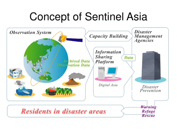
Origin of Sentinel-1 Mission • Sentinel satellite family represent new development by ESA for Global Monitoring for Environment and Security (GMES) space component • Sentinel-1 imaging SAR mission aimed at providing continuity of data for user services • Initial mission definition through ESA GSE services with additional inputs from EU GMES activities • Main application areas covered: • Monitoring sea ice zones and the arctic environment • Surveillance of marine environment (wind speed, oil spills, ship detection) • Monitoring land surface motion risks • Mapping of land surfaces: forest, water and soil, agriculture • Support to humanitarian aid in crisis situations
ESA EO Programme Overview 00 15 95 10 05 CryoSat1 GOCE Earth Explorers SMOS Science ADM-Aeolus ERS-1, 2 ENVISAT Swarm Earthcare EE7 Earth Watch Applications Services Sentinels GMES 1 CryoSat-2 in 2009
Key programmatic guidelines for mission requirements • Continuity of data for user services • Data availability – no data gaps w.r.t. ENVISAT ASAR/ERS-2 • Long term commitment to data provision • Data quality e.g resolution, radiometry compatible with existing SARs – deviations in system parameters require careful analysis of impact • User driven mission • Respond directly and demonstrably to user requirements • Traceability between user, mission and system requirements • On-going dialogue with user service community => some users only recently exposed to GMES services through ESA GSE and EU projects • Conflict-free satellite operation for reliable access to data and exploitation of archive
Derivation of Mission Requirements User Service Requirements Mission Requirements System Requirements • Data availability (Continuity, quality, Operations, Processing and archiving, Distribution) • Coverage and revisit • Timeliness • Characteristics of data products (e.g. spatial & radiometric resolution, swath width, polarisation • Detailed payload, system and ground segment specification of mission (e.g. Noise-equivalent Sigma0, Ambiguity ratio, antenna size) • Description of service/application • Description of radar information product • Geographical Coverage requirements • Access to data (e.g. timeliness)
Monitoring the European marine environment • Include the detection of oil spill pollution and ships • Key observation requirements • Daily coverage of marine transport corridors • Near-real time information delivery (< 3 hours with 1 hour as a goal) • Intensity product • Co-polar (VV or HH + cross polar) desirable
Driving application: provide pan-European ground motion hazard information service Key Mission Requirements Interferometry Twice-weekly measurements of subsidence over all major urban areas Regular surveillance over all major urban areas (every two weeks for gas pipelines) Archive for building up time series Monitoring and Assessing Land Surface-Motion Risk
Driving application: support operational service of prevention, anticipation and response to natural hazards Key Mission Requirements Seasonal high-resolution imaging of areas burnt by forest fires On-demand rapid delivery of data over hazard Multi-polarisation for best classification results Archive for comparison with past Forest Fire and Flood Management
Mission Requirements Document (MRD) • Based on analysis and distillation of user requirements from ESA GMES service element program (GSE) • Total of 18 mission requirements are formulated and discussed in the MRD (http://esamultimedia.esa.int/docs/GMES) • Three mission design elements appear as keys to meeting user requirements • Revisit • Coverage • Timeliness • Additional mission requirements cover data availability, data product characteristics incl. resolution, radiometric characteristics
Coverage and Revisit • For interferometry, global exact repeat coverage shall be achieved within interval of less than 14 days (MR9) • Automatically satisfies applications requiring monthly or annual global coverage • Fast global access on-demand shall be provided (MR10) • Required for humanitarian aid - assumes that revisit time through systematic acquisitions not sufficient • Daily full coverage shall be achieved north and south of +-45 degree latitude (MR11) • Requirement traceable to ice monitoring and marine environment (ship detection, oil spills) services • Two satellite baseline not sufficient to meet requirement => collaboration and interoperability with non-ESA SAR system required
Observation Requirements – Swath Width • The swath width shall be at least 240km (MR15) • Swath width user requirements often a proxy for revisit/coverage • Services mapping fast changing phenomena (sea ice, ship detection) do require a minimum instantaneous swath width • Compromise on spatial resolution and radiometric data quality possible for some services (sea ice) but impact others (ship detection, interferometry) • A wave mode shall be provided with 20 x 20km every 100km along track (MR16) • Follows from continuity of service requirement
Observation requirements - polarisation • The choice of polarisation depends service => continuity with ENVISAT ASAR implies consideration of HH, VV & cross-pol. • Sea ice: currently based on HH or VV, cross-polar shows improved capacity for iceberg detection • Wind speed, oil spill detection: require VV • Ship detection: HH best for incidence > 45 degrees, cross-pol for steeper incidence angles • Services based on land cover classification: require more than one polarisation for enhanced classification • The main mode of observation shall be VV+VH (MR17) • Optional additional modes shall be provided incl. HH+HV (MR18)
Cross-pol. mode for ship detection • For VV+VH mode over water, cross-pol. channel to provide ship information Vachon and Geeling (2005)
Baseline Technical Concept • Orbit: 12 day repeat • Operational Modes: IW (5x20m, 240km), EW (25x80m 3L, 400km), SM (4x5m, 80km), WM (20mx5m, 20kmx20km) • Polarisation: Dual pol all modes VV+VH or HH+HV • NESZ: -22 dB • Radiometric accuracy: 1.0 dB • Launch date: mid 2011 • Operations: • Consistent, reliable conflict free mission operations • NRT delivery within 3h (worst case) with 1h goal • Data from archive within 24 hours • Expected to work in pre-programmed fashion, imaging of global land masses, costal zones, shipping routes (IW) and covering the ocean with imagettes (WV mode)
Conclusions • Sentinel-1 mission aims to satisfy its user requirements in terms of data availability, coverage & revisit, timeliness and the quality of its data products. • IW forseen as major mode with wide swath, high resolution, multipolarisation, interferometric capability • Instrument trade-off studies under way supporting the assessment of radar system parameter impacts • Future work: • International cooperation required to achieve revisit time requirements (interoperability with Canadian radar constellation desirable) • Continued verification of mission concept with GMES programmatic requirements and evolution of service community