Download
1 / 32
320 likes | 472 Views
Atmospheric Monitoring of TA [Japanese WG]. M Chikawa, J Kaku Kinki University N Hayashida ICRR and TA group. 26th Feb 2004 : ICRRsympo. Atmospheric structure. change its transmittance in spatial and vary with time

E N D
Atmospheric Monitoringof TA[Japanese WG] M Chikawa, J KakuKinki University N Hayashida ICRR and TA group 26th Feb 2004 : ICRRsympo
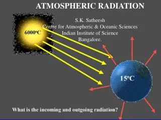
Atmospheric structure change its transmittance in spatial and vary with time → important to know its structure and time variation → back scatt., side scatt., sunphoto meter etc. z atmosphere scattering process Rayleigh(molecule) depends on ρ(z) Mie(aerosol) depends on aerosol wide and local area time density ρ(z) cloud aerosol dust, vapour, mist, fog wind
Air fluorescence light luminescence from Nitrogen 315.9 nm (N2) 337.1 (N2) 357.1 (N2) 391.4 (N2+) UV
Estimate Mie leffect near ground surface (Simulation by Ogio(TIT)) EAS generated events = 100, arrival zenith angle : uniform energy =10^20 ev (fixed) Fluorescence light 3km TA without anycut for the data cut data w/i 3km on the ground
Atmospheric Monitoring • Contribution by Japanese Atmospheric Monitoring group [our future plan for final design] - lidar system : transparency of atmosphere as far as possible feasibility study at AKENO suggests aspect to determine extinction coefficient by 20km : fix Lidar How to… shoot, DAQ, analyze,and calibrate, etc. - IR(infra red) camera available to use cloud monitor Observe all sky region → IR camera + convex mirror - astro dome will be settled on the roof of each three stations in order to install Liar systems These are the issues that Japanese Atmosperic WG is going to do for TA.
back scattering(LIDAR method)& side scattering(phase function method) θ=180 0<θ<180 θ Laser
Utah 7 telescope (3mφ) + HiRes laser : 1999 • Mie scattering coefficient • 0.001 km-1 • Mie Phase function • Modified Henyey-Greenstein
5mJ Infrared Camera 16cm
Lidar Experiment at AKENO Inclined Laser shots laser pulse vertical , horizontal, and arbitrary direction ↓ detect using PMT w/mirror scattered light intensity elapsed time → distance from laser Lidar
Assumption for analysis To evaluate the extinction coeff. from Lidar data, Simple & convenient assumption for structure of atmosphere is applied. 1, only Rayleigh Scattering>10km Assume this behaviour, develop a new Lidar system Inclined Laser shots 2, Atmosphere Almost Uniform In Horizontal direction Lidar 3, Measure Horizontal: Rayleigh+Mie
Akeno data 15/Oct/2003 • Lidar exp’t at Akeno • Typical sample of good results • Corrected intensity of scattered light PxR2 vs. light path length
Back scattered exp’t [ Lidar ] R&D @ Akeno w/ steerable system Mirror diameter 15cm, laser power 5mJ 3-dimension measurement : ≦10km in vert. & horiz. condition α ± Δα fine 0.0639 ± 0.0005 hazy 0.1394 ± 0.0005 0.1645 ± 0.0010 cloudy 0.3254 ± 0.0016 ⇒ should be measured far distance ~20km solution : install larger mirror, higher power laser
A new lidar system R&D : Meade LX200GPS Schmidt-Cassegrain Telescope w/ UHTC(ultra high transmission coating) • RS232C controllable by PC linux thru Network prototype just begin to studyat Kinki Univ. • will have next devices piggy back YAG laser : ( 355nm 2-3mJ 5ns pulse width) + PMT 3/4” diameter + mirror + Digital Oscilloscope (+ Energy meter ) • FOV : approx. 1 degree
1/2 parameters of the lidar system required specification for Lidar system to determine extinction coeff. approx. 20km with few % error Off-line analysis : analyze Lidar data from each station independently
IR Camera Cloud monitoring Sensitivity : 8 -14μm -20 ゜ ~ 300 ゜ FOV:25.8゜(H)×19.5゜(V) 320×236 pixel digital value temperapure
IR Camera Cloud monitoring • IR camera on a steerable system: Akeno Lidar system • IR camera use 2-dimensional cloud monitor and measure distance by Lidar 3-dimensional cloud monitoring • option : VTR(visible light) for all-sky waether monitor IR camera on AKENO lidar system
distribution of temperature The cloud region is warmer than background sky !
differential coeff. threshold cut digitize: B&W calculates of edge of the cloud
Astro dome • Settle an astrodome nearby the telescope station (not roof top) install a new LIDAR system inside astrodome
大気透明度モニターの配置案 (後方+側方散乱の併用で誤差10%大気透明度モニターの配置案 (後方+側方散乱の併用で誤差10% 以内を目標。) 4th Lidar Station 後方散乱Lidar の 守備範囲 (20 km 以内) 垂直射出側方散乱の 守備範囲 (2ヶ所でサンドイッチ)
Astro dome Ovservation room : square (left) and round shape(right) Round type is better than square type for protection of wind, snowfall, etc.
Discussion • Range of extinction length : 20km may be OK, but enough? feasibility study at Akeno supports 20km measurement: realistic limit value for our Lidar system during laser shooting to measure might be serious problem for DAQ of E>1018eV, EAS ratefrom AGASA ★ext. lengthα has largedependence of the empirical parameter k (=0.6 to 1.3) in the model feasibility study to measure absolute light intensity by PMT free from model dependence for Rayleigh scattering • LIDAR : steerable system need to establish robust system using commercial product • Astro dome : settle on the ground nearby the TA station • IR camera all sky monitoring and off-line data analysis can be available And I really understand it’s very difficult to know atmospheric properties in detail. → challenging subject!!