Megadrought Impacts on Colorado River Basin: Climate Vulnerability Study
Explore the susceptibility of the Colorado River basin to megadroughts in a warming climate, with severe implications for water resources in the southwestern US. Assess future scenarios and land-atmosphere feedback to predict potential perpetual drought conditions. Investigate temperature sensitivities, precipitation elasticities, and seasonal runoff changes using advanced modeling techniques.

Megadrought Impacts on Colorado River Basin: Climate Vulnerability Study
E N D
Presentation Transcript
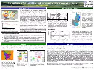
. UW Civil and Environmental Engineering Susceptibility of Colorado River basin to megadroughts in a warming climate Dennis Lettenmaier Project Overview Task 1: Preliminary Results The Colorado River, a critical water resource to the southwestern United States, has been experiencing dry conditions that have now persisted for almost a decade. The ongoing drought has the inferred severity of the “megadrought” of the 1100s, thought to be the most severe drought within the last 1300 years, and corresponds to a 25-year mean that is 85 percent of the naturalized flow of the 100+ years of the stream gauge record, and persisted for several decades. IPCC AR4 GCM studies suggest, averaged across many models, that Colorado River flows by the middle of this century will be of order 70 percent of the 20th Century mean, and will further decline by the end of the century. If correct, these simulations suggest that the Colorado River basin will enter a state of perpetual drought more severe than the megadrought of the 1100s. However, other approaches using IPCC AR4 climate scenarios, but with statistical downscaling to prescribe off-line forcing to a land hydrology model, concluded that decreases in Colorado River runoff by mid-century will be as little as 6 percent. When adjusted for methodological differences, this resulted in inferred runoff decreases of about 13 percent in the annual average. By using a regional climate modeling framework, we address shortcomings that underlie both of the earlier approaches, and further assess: Will the Colorado River basin, and the U.S. Southwest more generally transition to a permanent megadrought state over the next century, and what role will land-atmosphere feedbacks play in those changes relative to remote climate forcings? Precipitation Elasticity and Temp Sensitivity Spatial Distribution of Temperature Sensitivities In the upper Colorado River basin, most increases in temperature result in decreases in runoff. There are, however specific locations that have runoff increases. The figure on the left indicates temperature sensitivities in VIC model simulations where Tmin and Tmax were both increased by equal amounts. Note the spatial distribution of runoff increases (red), the mechanisms behind these increases will be explored in future work. Soil Moisture Conditions in November 2007 (expressed as percentiles relative to 1915-2003 climatology) show widespread drought, particularly in the Colorado River basin (blue circle). Precipitation elasticities and temperature sensitivities (for annual discharge at Lees Ferry) for VIC, NOAH, and SAC models. While precipitation elasticities are quite similar, temperature sensitivities vary greatly depending on whether the change in temperature is applied to the entire range or just to Tmax. Seasonal Runoff Multimodel averages over the Colorado River basin from 19 IPCC AR4 GCMs, A2 emission scenarios. Note drastic decline in P-E by 2100. Model Output courtesy Richard Seager. Composite seasonal water balance for the 25% of the Colorado River basin that produces most (about 75%) of its runoff, by quartile of the temperature sensitivity distribution (lowest quartile has the smallest (most negative) temperature sensitivities. Black line is for runoff, and shows that those grid cells with smallest (most negative) temperature sensitivities tend to produce the most runoff, contrary to the Dettinger Hypothesis. Results are for the VIC model, but results for NOAH and SAC (Sacramento) models are qualitatively similar. • Complementary Science Questions • 1. How are interseasonal, interdecadal, and future projected climate change in the land-atmosphere dynamics of the Colorado River basin affected by feedbacks associated with a transition to early snowmelt, and hence occurrence of maximum soil moisture earlier in the year when evaporative demand is lower? • 2. How might perpetual “climate change drought” associated with reduced moisture flux convergence over the Colorado River basin compare with pre-instrumental megadroughts inferred to have occurred in the paleo record of the last 1000 years? • 3. How do the atmospheric dynamics and land-atmosphere feedbacks of recent drought years in the Colorado basin compare with projected long-term changes over the next century, i.e., to what extent can recent drought years be considered a harbinger of future conditions? Methods Next Steps In previous studies, the GCM approach was unable to resolve highly skewed (towards high elevation areas) source areas for runoff like the western U.S, whereas the land hydrology model approach decoupled the hydrologic forcing with the atmospheric circulation. To overcome these shortcomings, we use a regional climate model (Weather Research and Forecasting model) coupled with a land hydrology model (Variable Infiltration Capacity model). Through collaboration with Dr. Rudy Leung of the Pacific Northwest National Laboratory, we will continue our efforts to understand how increasing global greenhouse gas concentrations over the next century will change the susceptibility of the Colorado River basin to megadroughts. Our next step is to implement the coupled WRF-VIC model over the NARCCAP domain (continuation from Task 1). WRF-VIC will then be implemented for the 20th century GCM simulations and for future simulations. We will compare differences between the 21st and 20th century simulations and will particularly compare differences between the coupled WRF-VIC simulations of runoff, as well as snow and soil moisture storage, precipitation, and evapotranspiration between the regional climate runs and the GCM from which the boundary conditions will be taken. Our working hypothesis is that evapotranspiration will be less, runoff greater, and possibly that precipitation will be greater in the regional model runs than in the GCMs. Therefore, we further hypothesize that the magnitude of projected 21st century hydrologic change over the Colorado basin will be less in the higher resolution regional climate model runs than in the GCMs. The next step will be performing diagnostic studies of the nature of land hydrologic feedbacks as they are predicted to affect runoff response to climate change in the Colorado River Basin. Finally, we will evaluate the nature and implications of land surface feedbacks in recent drought years, focusing on water years (Oct-Sep) 2002 and 2004. The primary mechanism for dissemination of results will be through publication in the refereed literature. We will maintain an archive of model output, which will be made available to the broader community. Research funding provided by Department of Energy Driving data: Historical conditions (North American Regional Reanalysis and/or CMIP 20th century model runs) for boundary conditions as well as boundary conditions taken from 21st Century (IPCC AR4) model simulations. Sea surface (temperature) boundary conditions will be as in the North American Climate Change Application Project (NARCCAP). NARCCAP domain is indicated (above), colors show vegetation types. Regional climate model: The Weather Research and Forecasting (WRF) is a mesoscale numerical weather and climate prediction system. Land surface model: The Variable Infiltration Capacity (VIC) is a macroscale energy and water balance model +