Download
1 / 26
260 likes | 357 Views
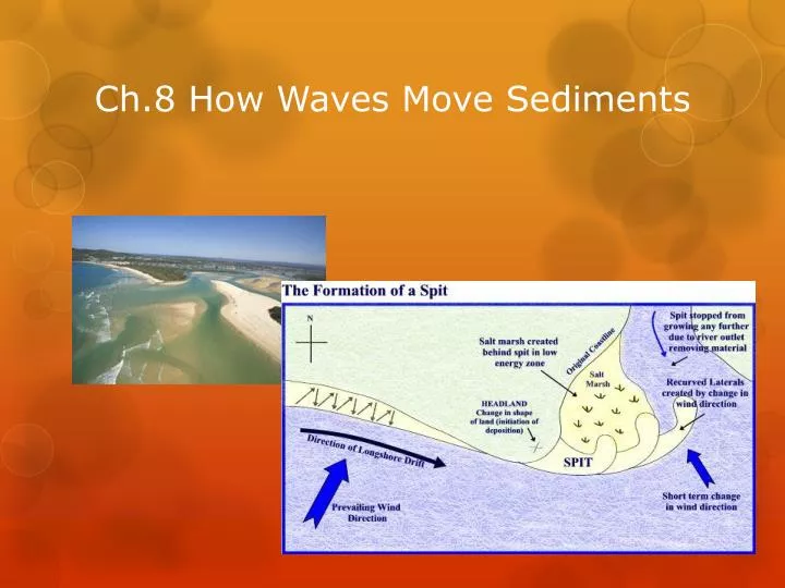
Ch.8 How Waves Move Sediments. Longshore Drift. Longshore drift has a very powerful influence on the shape and composition of the coastline. It changes the slopes of beaches and creates long, narrow shoals of land called spits, that extend out from shore.

E N D
Longshore Drift • Longshore drift has a very powerful influence on the shape and composition of the coastline. It changes the slopes of beaches and creates long, narrow shoals of land called spits, that extend out from shore. • Longshore drift may also create or destroy entire “barrier islands” along a shoreline. • A barrier island is a long offshore deposit of sand situated parallel to the coast. As longshore drifts deposit, remove, and redeposit sand, barrier islands constantly change.
NJ Coastal Zone Monmouth County headlands consist of beaches backed by a bluff of older sediments and two major sand spits One to the north from Long Branch (Sandy Hook) One to the south from Bay Head (Mantoloking to Island Beach State Park) The barrier island segmented shoreline covers the remainder of the NJ coastline where individual islands are separated from the mainland by a series of bays and tidal lagoons
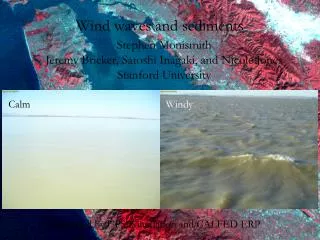
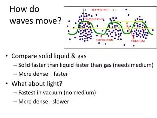
Waves, Beaches, and Coasts Water waves are another agent of erosion, transportation, and deposition of sediment. Along the shores of oceans and lakes, waves break against the land, building it up in some places and tearing down in others. • The energy of the waves comes from the wind. This energy is used to a large extent in eroding and transporting sediment along the shoreline. Understanding how waves travel and move sediment can help you see how easily the balance of supply, transportation, and deposition of beach sediment can be disturbed. Such disturbances can be natural or human-made, and the changes that result often destroy beachfront homes and block harbors with sand. • Beaches have been called "rivers of sand" because breaking waves, as they sort and transport sediment, tend to move sand parallel to the shoreline. In this chapter we look at how beaches are formed and also examine the influence of wave action on such coastal features as sea cliffs, barrier islands, and terraces.
Views of UCSB Beach at three different times of year. The upper left is during the fall, when the sand is high. The upper right is after the first winter storm, and the figure to the left is in January. During this quarter, and while you are at UCSB, be sure to notice the effect of storms on our beach.
Longshore Drift • Tucker’s Island, New Jersey, is a barrier island that clearly illustrates how longshore drift and strong weather affect these transient sand deposits. • The island was first settled in 1735. Since its settlement, residents have had to move the island’s lighthouse several times because the channels shifted constantly as a result of longshore drift. Eventually, they placed the lighthouse on high ground at the island's northern end. • Meanwhile, the inlet north of Tucker’s Island—Beach Haven inlet—was also effected by longshore drift. At times, the inlet was narrow or nonexistent and Tucker’s Island was attached to the nearby Long Beach Island. At other times, the inlet was wide, and Tucker’s Island was separated from Long Beach Island.
In 1927, the lighthouse on Tucker's Island, NJ was destroyed when powerful longshore currents washed over 300 yards of the surrounding land out to sea.
Barnegat Light • Barnegat Light has seen significant advancement from 1986 to 2006 • The Barnegat Inlet jetty was constructed between 1988 and 1991, and upon completion it began trapping sand
Barnegat Inlet Figure 7. Inlet channel conditions at Barnegat Inlet, New Jersey, August 1944.
Ocean County • Shoreline is open to free littoral sand transport • Narrow beach width and extensive development limit dune development and storm protection • Large advances around Barnegat inlet were due to jetty reconstruction • State conducted large truck-fill in Harvey Cedars (1994 - 1995) • First substantial Federally funded beach restoration project in Surf City, L.B.I (2007) • Undeveloped area in Holgate lies down-drift from the 97-groin field along L.B.I and has been impacted by long-term shoreline change
Figure 178. Maps showing the progressive shoreline changes at Sandy Hook (after NPS Spermaceti Cove Visitor Center display).
Sandy Hook Figure 179. Sedimentation features on aerial photographs of Sandy Hook: A. Plum Island represents the remnants of a washover fan. The sawtooth pattern along the Atlantic Ocean side reveals the buildup of sand adjacent to stone groins transported northward by longshore drift. B. an accretionary sandy buildup on the northern tip of the spit. The large dark area is a newly-formed freshwater pond. The dotted straight line is the 9 Gun Batter completed in 1902.
The Impact of Storms • Hurricanes • Nor’Easters
Sources • Surf Science – An Introduction to Waves for Surfingby Tony Butt, Paul Russel, Rick Grigg • Kurt Korte – Surfline • NOAA • Surfline • Richard Stockton College of NJ