Download
1 / 22
220 likes | 378 Views
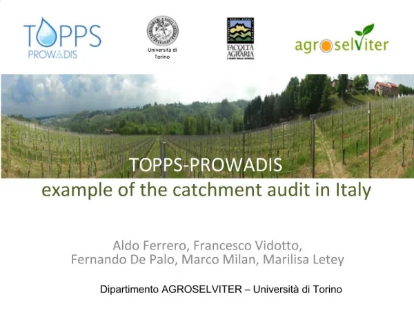
Università di Torino. TO PPS-PROWADIS example of the catchment audit in Italy. Aldo Ferrero, Francesco Vidotto, Fernando De Palo, Marco Milan, Marilisa Letey. Dipartimento AGROSELVITER – Università di Torino. Catchment audit in Italy: the Tiglione valley. Tanaro. Tiglione.

E N D
Università di Torino TOPPS-PROWADIS exampleof the catchment audit in Italy Aldo Ferrero, Francesco Vidotto,Fernando De Palo, Marco Milan, Marilisa Letey Dipartimento AGROSELVITER – Università di Torino
Catchment audit in Italy: the Tiglione valley Tanaro Tiglione Sub catchment about 3300 ha 2 provinces (Asti, Alessandria) 9 municipalities Tiglione catchment about 6900 ha 2 provinces (Asti, Alessandria) 17 municipalities Tiglione stream Tiglione stream lenght in the sub-catchment: 18.0 km total lenght: 25.7 km
Catchment audit in Italy: the Tiglione valley Three areas selected for audit Demonstration Catchment areas (DC areas) DC1 DC2 DC3
Catchment audit in Italy: demonstration catchment areas • each area includes • alluvial plain of Tiglione(both on right and left sides) • slopes Vineyards • crops • alluvialplaincereals, patches of permanentmeadows and some poplarplantations • slopes: vineyards or naturalvegetation TIGLIONE Arablecrops • accessibility • tworoadsrun ~ parallel to the twosides of Tiglione (150-300 m)
Diagnosis preparation: geographical information available Collection of maps and data - Technical regional map - Orthophoto map - Water network - Slope from Digital Terrain Model (DTM) - Nature of the geological substrate - Lithological units - Permeability of the geological substrate - Topsoil texture, stoniness, reaction - Hydromorphy - Soil water holding capacity and drainage level - Capping risk - Soil destination Use of OpenSource GIS software Quantum Gis GRASS
Diagnosis preparation: geographical information available GIS data processing Always >120mmno saturationexcess From 0 to 60% Mostly HIGH slope capping risk water holding capacity Runoff risk typeclassification (Aquavallée decision tree)
Field diagnosis: validation Terrain survey in the demonstration catchment areas • soil characteristics • water circulation • agronomic practices • landscape factors • runoff/erosion effects
Field diagnosis: validation Erosion on the hillside zone
Field diagnosis: validation Concentrated runoff with erosion in thalwegs
Field diagnosis: validation Sediment deposition
Field diagnosis: validation Presence of short cuts (direct connection between hillside zone and river) Tiglione
Field diagnosis: validation Excessive plowing depth in the alluvial zone 60 cm
Field diagnosis: riparian audit Carried out on both sides of the Tiglione
Field diagnosis: riparian audit Large variability of conditions • presence/absence of riparian buffer • presence/absence of shrubs and trees on the banks • soil tillage close to the bank in some fields
Field diagnosis: riparian audit Large variability of conditions:landslides (lateral seepage and bare bank) Low permeability layer
Audit conclusions Peculiarities of the Tiglione catchment • Presence of infiltration excess runoff mainly • Occurrence of severe erosion problems in the hillside • Serious problems of stability along the Tiglione banks • Several short-cuts • Diffuse adoption of plowing carried out in autumn at an excessive depth
Proposed actions Riparian zone • Introduction of riparian buffer zone with reinforcement of the banks • Adoption of dispersion structures (e.g. brushwood fascines) at the end of shortcuts Alluvial plain • Adoption of shallow plowing • Use of cover crops • Avoid seeding too close to the river banks • Favor the growth of herbaceous vegetation in the shortcuts Hillside zone • Promote growth of herbaceous vegetation (either spontaneous or seeded) in the inter-row • New plantations (vineyard) perpendicular to the slope • Reduce vulnerability to runoff/erosion of the access roads
Proposed actions: RIPARIAN ZONE Grassed buffer strip and tree vegetation
Proposed actions: RIPARIAN ZONE Dispersion structures: fascines, wooden barriers, etc.
Proposed actions: HILLSIDE ZONE grassed drainage ditch (with barriers) BETWEEN the tracks
Next steps • Meetings with local farmers and authorities to involve them and gather additional information • Implementation of BMPs in the most critical situations • Demonstration/training activities into the selected catchment area with national stakeholders