Download
1 / 15
150 likes | 183 Views
This workshop delves into the latest updates and insights on geoid modeling, focusing on models such as USGG2012 and GEOID12A. Topics include GRAV-D, GSVS 11 & 14, GOCO02S, and EGM2008. Discussions cover hybrid geoid height models, gravimetric geoid systems, and conversion surfaces utilizing GPS data. Insightful comparisons between different geoid models are highlighted, showcasing significant changes in various regions. Future work involving aerogravity data collection, geoid modeling, and rigorous geoid model processing standards are outlined. Special emphasis is placed on regional collaboration, refining data processing SOPs, and comparative analysis with other gravity models.

E N D
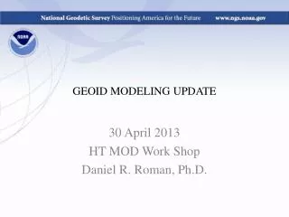
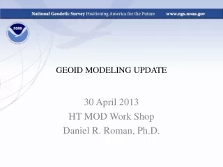
GEOID MODELING UPDATE 30 April 2013 HT MOD Work Shop Daniel R. Roman, Ph.D.
Outline • USGG2012 • GEOID12A • GEOID12A Error Map • GRAV-D • GSVS 11 & 14
USGG2012 • GOCO02S + EGM2008 + 3”-5’ RTM + ~ two million surface gravity \||/ \/ • One-arcminute (1’) nodes • IGS08-based reference • GRS-80 ellipsoid shell • W0 = 62,636,855.69 m2/s2 Note: this is not the value adopted with Canada Min =-52.53 m Max = 3.47 m Ave = -29.84 m SD = 10.35 m GOCO02S is a combination of GRACE, GOCE, CHAMP and SLR Goiginger H., Rieser D., Mayer-Guerr T., Pail R., Schuh W.-D., Jäggi A., Maier A., GOCO Consortium (2011): The combined satellite-only global gravity field model GOCO02S. European Geosciences Union General Assembly 2011, Wien, 04.04.2011.
h h h h H h H H H N N N H N N Hybrid Geoid Height Models (e.g., GEOID12A), Gravimetric Geoid Height Models (e.g., USGG2012) and Conversion Surfaces using GPS on BM data Earth’s Surface • Gravimetric Geoid systematic misfit to BM’s but best fits “true” heights • Hybrid Geoid“converted” to fit local BM’s, so best fits NAVD 88 heights • Conversion Surface model of systematic misfit derived from BM’s in IDB Ellipsoid Hybrid Geoid Gravimetric Geoid
GEOID12A – GEOID09 • GEOID12 • Biggest changes • Gulf Coast • Ellipsoid – NA2011 • Vertical – HT MOD 2012 • Spreading East/West • Minor changes central part • Wisconsin • Mountains in West (RTM) • Scattered GPS/OPUS BM’s • Changes are 1/3 those of GEOID09-GEOID03 GEOID12A Min = -50.71 m Max = 3.31 m Ave = -29.48 m SD = 10.06 m GEOID09 Min = -50.68 m Max = 3.44 m Ave = -29.47 m SD = 10.05 m GEOID12A – GEOID09 Min = -44.5 cm Max = 54.5 cm Ave = -1.3 cm SD = 5.1 cm GEOID09 – GEOID03 Min = -226.9 cm Max = 171.8 cm Ave = 2.0 cm SD = 16.6 cm
GRAV-D • Vertical Datum surface chosen with Canadians W0 = 62,626,856.0 m2/s2 • >25% flown • Data shared with Canadians over GL & AK • Data shared with Mexico in SW • First attempts made to clean terrestrial gravity Map Key - Airborne Gravity Data Green: Available data and metadataBlue: Data being processedOrange: Data collection underwayWhite: Planned for data collection
GSVS 11 • Goal: to provide relative geoid height from field observations at an accuracy of ±1.4 cm along a line of 325 km • Data Collected: • Terrestrial gravity • Absolute • Relative • Gradients • Aerogravity (TX09 flights) • Astrogeodetic DoV • GPS (processed multiple ways) • Leveling • GPS & leveling minimally constrained • Outcome: sub-cm comparison along the profile (GPS/leveling vs. gravimetric geoid)
GSVS 14 Line Goal: Same as GSVS 11 Region: Moderate terrain Data: Same as GSVS 11 Timeline: Pushed to the right into FY 14
GRAV-D: Future Work • Continue aerogravity collection • NGS and contractors • UAS • Refinement of aerogravity processing SOP’s • Regional Collaboration • CGG2013 – Emphasis of Great Lakes • Mexican gravity – absolute sites • IGLD 15 • Comparisons over Rockies
GRAV-D: Future Work (Cont.) • Geoid Modeling • Cleaning of terrestrial gravity data • Production of seamless gravity field models • Adoption of more rigorous geoid modeling SOP’s • Comparisons • With CGG2013 (and follow-on models) • With GGM2010 (and follow-on models) • SIRGAS & WHS • Tidal Bench Marks/MSSH (LMSL = MSL + MODT) • GSVS 11/14/??
GRAV-D: Future Work (Cont.) • Completion: • Aerogravity: 2020 to 2022 • Geoid Modeling: 2022 • Implementation: • Interim models on GRAV-D website • Future USGG20xx may adopt aerogravity • Dependent on impact of incomplete coverage • Eventually will be a geoid height model in same ellipsoidal reference frame as geometric datum • Akin to the output currently provided by OPUS
Questions? Geoid Modeling Gravity Collections www.ngs.noaa.gov/GRAV-D Dr. Vicki Childers GRAV-D P.M., Aerogravity Ms. Monica Youngman Asst. GRAV-D P.M., Project Lead Dr. Theresa Damiani Kinematic GPS, Aerogravity Ms. Sandra Preaux Aerogravity Theory & Practice Mr. Mark Eckl Chief OAD, Abs. & Rel. Gravity • www.ngs.noaa.gov/GEOID • Dr. Yan Wang • Geoid Theory, Physical Geodesy • Dr. Dan Roman • GRAV-D P.I., Physical Geodesy • Dr. Simon Holmes • EHM/SHM, Physical Geodesy • Dr. Xiaopeng Li • GPS/INS, Physical Geodesy