Download
1 / 11
150 likes | 390 Views
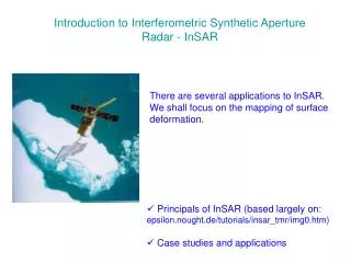
Iceberg Detection Using RADARSAT-1 Synthetic Aperture Radar. Kelley Lane Research Engineer, C-CORE Kelley.Lane@c-core.ca. Ice Management and RADARSAT. Effective ice management is important in ship navigation and offshore resource exploration in Newfoundland

E N D
Iceberg Detection Using RADARSAT-1 Synthetic Aperture Radar Kelley Lane Research Engineer, C-CORE Kelley.Lane@c-core.ca
Ice Management and RADARSAT • Effective ice management is important in ship navigation and offshore resource exploration in Newfoundland • Regions such as the Grand Banks which are characterized by considerable fog, cloud, and precipitation, rely on radar-based systems as the primary sensing tool • Four primary radar tools for iceberg surveillance • Ship/rig based marine radar • Airborne radar • Coastal HF radar • RADARSAT-1
Target Detection Software • C-CORE has been involved in a multi-year program investigating the target detection capabilities of RADARSAT-1 • To aid in this research an automated Target Detection Software (TDS) has been developed for the detection and discrimination of icebergs • TDS has been used in several Near-Real Time demonstrations and is currently being used operationally
Target Detection in imagery • Mean level of sea clutter varies depending on the wind speed and the range of incidence angles • Detection of targets in the presence of sea clutter relies on adaptively determining an appropriate threshold level • Constant Fault Alarm Rate (CFAR) - determines a threshold in a localized area. • The sea clutter distribution along with a specified CFAR is used to derive an appropriate threshold for the detection of possible targets
Volume scattering (most dominant) • due to the low absorption of the non-saline glacial ice allowing considerable penetration of the radar energy into the iceberg volume Incoming Radar Signal Volume Scattering Surface Scattering Surface scattering • dependent on the specific surface structure of individual icebergs, including variations due to any snow or water on the surface of the iceberg
Ships Versus Icebergs Generally, pixel statistics can be used to discriminate between icebergs and vessels • Generally, vessel targets have stronger echoes resulting in higher pixel mean and variance • hard to discriminate in lower resolution data due to lower numbers of pixels available for statistics • shape characteristics may also be used (icebergs are generally more irregularly shaped while vessels tend to be elongated) • Work is being conducted on the discrimination of ships and icebergs
Ships Versus Icebergs Generally, pixel statistics can be used to discriminate between icebergs and vessels • Generally, vessel targets have stronger echoes resulting in higher pixel mean and variance • hard to discriminate in lower resolution data due to lower numbers of pixels available for statistics • shape characteristics may also be used (icebergs are generally more irregularly shaped while vessels tend to be elongated) • Work is being conducted on the discrimination of ships and icebergs
RADARSAT ScanSAR Narrow Image 50 metre pixels Hibernia Supply Boat
RADARSAT ScanSAR Narrow Image 50 metre pixels 70 m 130 m 200 m 90 m islands
170 m 60 m 100 m RADARSAT Wide3 Image 30 metre pixels
RADARSAT Fine Image ~8 metre pixels