Download
1 / 2

E N D
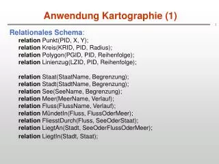
Anwendung Kartographie (1) Relationales Schema:relation Punkt(PID, X, Y);relation Kreis(KRID, PID, Radius);relation Polygon(PGID, PID, Reihenfolge);relation Linienzug(LZID, PID, Reihenfolge);relation Staat(StaatName, Begrenzung);relation Stadt(StadtName, Begrenzung);relation See(SeeName, Begrenzung);relation Meer(MeerName, Verlauf);relation Fluss(FlussName, Verlauf); relation MündetIn(Fluss, FlussOderMeer);relation FliesstDurch(Fluss, SeeOderStaat);relation LiegtAn(Stadt, SeeOderFlussOderMeer);relation LiegtIn(Stadt, Staat);
Anwendung Kartographie (2) Beispiele: • “Deutsche Städte, die am Rhein liegen”: StadtName(StaatName = 'Deutschland' (LiegtIn) bSeeOderFlußOderMeer = 'Rhein' (LiegtAn) • “Deutsche Flüsse, die in die Nordsee fließen”: FlussName(SeeOderStaat = 'Deutschland' (FliesstDurch) bFlußOderMeer = ’Nordsee' (MündetIn) • “Deutsche Flüsse, die - direkt oder indirekt - ihre Wasser in die Nordsee entleeren”: Nicht darstellbar!