Download
1 / 50
570 likes | 968 Views
Watershed Management Water Budget, Hydrograph Analysis . Hydrology and Water Resources -RG744 RS and GIS c , Institute of Space Technology October 30, 2013. An area that contributes flow to a point on the landscape

E N D
Watershed ManagementWater Budget, Hydrograph Analysis Hydrology and Water Resources -RG744 RS and GISc, Institute of Space Technology October 30, 2013
An area that contributes flow to a point on the landscape Basic hydrologic unit within which all measurements, calculations, and predictions are made in hydrology Watershed • Slopes are used to define watershed boundaries, flow paths and directions • Slope = change in elevation (a rise) with a change in horizontal position (a run)
Watershed may be quite small (few square meters in an area on a ridge or high slope) May be quite large including continental areas that drains large rivers (Mississippi Rivers, Indus Basin, etc.) Watershed
Set of cells through which surface water flows Convergence of flow direction may be used to produce streams or drainage network Defining a Stream: any cell that has a contributing watershed larger than some locally defined threshold Drainage Network
As a general rule, water flows downhill perpendicular to contour lines
Drainage Basin: Area draining to a common outlet • Drainage Divide: separates two watersheds that drain into different outlets • Drainage Area: Area encompassed by divide • Drainage Density: Stream length/unit area • Stream Order System: …. • Stream gradient: Drop of elevation/unit length • Stream Frequency: Number of channels/unit area • Basin Relief: Highest elevation – lowest elevation • Time of concentration: Time of travel from the farthest point in the catchment area to the gauging station Basin Characteristics
Stream Order 1st through 12th Order by Strahler's (1952)
Water Budget/Balance • Basin Hydrologic Mass Balance Inflow = Outflow ± Change in Storage • Inflows • Precipitation • Surface water Inflow • Groundwater Inflow • Artificial Import (Pipes) • Outflows • Evaporation (surface water, land areas) • Runoff • Groundwater Outflow • Artificial Export (withdrawal from surface and groundwater) • Storage • Surface water in streams, lakes and ponds • Soil moisture • Ice and snow on the surface • Temporary depression storage • Intercepted water on plant surfaces • Groundwater
Examples (10 + 5 + 4) – 19 = 0
Rainfall Runoff Response Flow Measured from USGS Gage 403 Inside Harris Gully RF Q Rainfall Measured from USGS Gage 400 at Harris Gully Outlet February 12, 1997 on Harris Gully
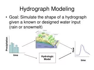
Input Catchment Output • To determine surface runoff from a watershed due to a particular storm • Rainfall and Runoff Relationship • Catchment may be treated as ‘black box’ having processes that control the rainfall to runoff transformation Rainfall and Runoff Analysis in Watersheds
Includes: • Overland flow • Precipitation falling directly on stream channels Depends on: • Basin Characteristics • Size, shape, slope, land use/cover, soil type, antecedent conditions • Storm Characteristics • Storm intensity, storm duration, spatial variation, movement • Hydrograph • Size, shape, condition of flow conveyance systems Surface Runoff
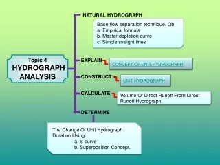
Hydrologic response of rainfall at the outlet of an area Hydrograph: Graph of discharge (cubic feet per second) in a channel vs. time Area under curve yields the volume of runoff Stream flow = Direct Runoff + Base flow Direct Runoff (DRO) = Rainfall Excess or (rainfall – losses) Hydrograph Analysis Source: Prof. Ke-Sheng Cheng
Direct Runoff • Surface runoff • Interflow or Quick Interflow: is runoff that infiltrates the top layers of soil and exits to stream prior to reaching zone of saturation • Baseflow: Entry of groundwater into stream • Delayed interflow: component of interflow which contributes to baseflow • Groundwater runoff: flow component contributed to the channel by groundwater (extremely slow) Hydrograph Component
Rising Limb Crest or Peak: Maximum rate of flow for the event Falling limb or Recession Curve Parts of Hydrograph
Climatic Characteristics • Rainfall intensity: higher intensity storm produces rapid rise in hydrograph and higher peak • Rainfall duration: important when duration is more than time of concentration • Temporal distribution: in summer greater losses lesser peak, in winter vice versa (also in winter soil moisture is high producing more runoff) • Spatial distribution: ??? • Catchment Characteristics • Size • Shape • Elevation • Slope • Drainage density and topology • Soil Type and land use Factors Affecting Hydrograph Shape
Size of the Catchment • Volume of runoff for a given rainfall input is proportional to the size of catchment • But the response characteristics of a large catchment is different from a small catchment • rainfall -runoff response for a smaller impervious catchments is different from a larger vegetative watersheds for a given rainfall Catchment Characteristics
Catchment with same area but with different shape • Narrow ends towards outlet • Slow rising hydrograph with lower peak Catchment Characteristics: Shape
Shape of Catchment • Pear shaped catchment with narrow ends towards upstream and broader end near outlet • Fast rising Hydrograph with high peak • Water passing through outlets of both catchment is same Catchment Characteristics
Elevation • Variation in temperature and precipitation at different elevation • Temperature reduces with the increase in elevation and at very high altitude precipitation falls as snow • The floods from snow melt are usually low peak and broader base Catchment Characteristics
Slope • Larger slopes generate more velocity than smaller slopes causing fast runoff • Same rainfall input to 2 catchments of equal area but different slopes, the one with steeper slope generates a hydrograph with steeper rising and falling limbs Catchment Characteristics
Surface Roughness Catchment Characteristics
Catchment Characteristics & Hydrograph Shape Also need to consider the storm duration and time of concentration. Source: Prof Cheng, Taiwan
What is observed flowing in the stream is the total discharge • The combined hydrograph can be split up into two parts: the base flow and the overland flow added to interflow • Process of separating the direct runoff from the base flow is called Baseflow Separation • Methods of Baseflow Separation: • Straight line method • Empirical Method • Inflection Point Method • All methods are arbitrary and somewhat inaccurate Baseflow Separation
This method is not very accurate Base Flow Separation: Straight Line Method
N (Days) N (in days) = 0.862 A0.2 A = area of the drainage basin in square kilometers (N= A0.2 , A is in miles) N is from the point of peak discharge to the point where flow is completely dominated by base flow Base Flow Separation: Empirical Method
tp = Time to peak discharge from start of rainfall Inflection point on the falling limb is often assumed to be point where direct runoff ends Base Flow Separation: Inflection Point Method
Example 2-1 (Bedient) Net Storm Rainfall and Hydrograph Discrete step method for calculating area under hydrograph
works best for long time periods Regression Analysis