Download
1 / 29
300 likes | 432 Views
Establishment of an Altimetric Reference Network over the Amazon Basin using Satellite Radar Altimetry (Topex Poseidon) Pascal Kosuth (1), Denizar Blitzkow (2), Gérard Cochonneau (3),

E N D
Establishment of an Altimetric Reference Network over the Amazon Basin using Satellite Radar Altimetry (Topex Poseidon) Pascal Kosuth (1), Denizar Blitzkow (2), Gérard Cochonneau (3), (1)TETIS – Cemagref France, (2) EP-USP Brazil (3) LMTG – IRD France
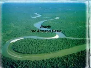
Hydrological and geochemical dynamics of the Amazon Basin Problem : * Determine the surface slopes (topography) of Amazonian rivers * Establish a consistent altimetric reference network over the Amazon Basin ESA – CNES “15 years of progress in radar altimetry” Symposium – Venice – March 2006 Establishment of an Altimetric Reference Network over the Amazon Basin using Satellite Radar Altimetry (Topex Poseidon) Kosuth P., Blitzkow D., Cochonneau G.
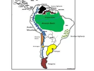
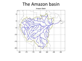
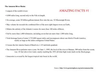
What are the surface slopes of Amazonian rivers ? Mean river discharge to the ocean ~209 000 m³/s [20% of continental input to oceans] Slope regulates river discharge floodplain storage, sediment transport Area : 6 112 000 km2 [5% of continental area] Hydrological and geochemical dynamics of the Amazon Basin ESA – CNES “15 years of progress in radar altimetry” Symposium – Venice – March 2006 Establishment of an Altimetric Reference Network over the Amazon Basin using Satellite Radar Altimetry (Topex Poseidon) Kosuth P., Blitzkow D., Cochonneau G.
Spirit topographical levelling DEMs GPS campaigns Satellite radar altimetry Problem : * Determine the surface slopes (topography) of Amazonian rivers * Establish a consistent altimetric reference network over the Amazon Basin Four techniques to solve the problem ESA – CNES “15 years of progress in radar altimetry” Symposium – Venice – March 2006 Establishment of an Altimetric Reference Network over the Amazon Basin using Satellite Radar Altimetry (Topex Poseidon) Kosuth P., Blitzkow D., Cochonneau G.
Hydrometric stations Rivers ESA – CNES “15 years of progress in radar altimetry” Symposium – Venice – March 2006 Establishment of an Altimetric Reference Network over the Amazon Basin using Satellite Radar Altimetry (Topex Poseidon) Kosuth P., Blitzkow D., Cochonneau G.
Levelling network Sprit levelling (topographical) ESA – CNES “15 years of progress in radar altimetry” Symposium – Venice – March 2006 Establishment of an Altimetric Reference Network over the Amazon Basin using Satellite Radar Altimetry (Topex Poseidon) Kosuth P., Blitzkow D., Cochonneau G.
GTOPO 30 DEM DEM ESA – CNES “15 years of progress in radar altimetry” Symposium – Venice – March 2006 Establishment of an Altimetric Reference Network over the Amazon Basin using Satellite Radar Altimetry (Topex Poseidon) Kosuth P., Blitzkow D., Cochonneau G.
GPS positionning GPS positionning ESA – CNES “15 years of progress in radar altimetry” Symposium – Venice – March 2006 Establishment of an Altimetric Reference Network over the Amazon Basin using Satellite Radar Altimetry (Topex Poseidon) Kosuth P., Blitzkow D., Cochonneau G.
Satellite radar altimetry (Topex Poseidon) ESA – CNES “15 years of progress in radar altimetry” Symposium – Venice – March 2006 Establishment of an Altimetric Reference Network over the Amazon Basin using Satellite Radar Altimetry (Topex Poseidon) Kosuth P., Blitzkow D., Cochonneau G.
Topex Poseidon ground tracks Satellite radar altimetry (Topex Poseidon) ESA – CNES “15 years of progress in radar altimetry” Symposium – Venice – March 2006 Establishment of an Altimetric Reference Network over the Amazon Basin using Satellite Radar Altimetry (Topex Poseidon) Kosuth P., Blitzkow D., Cochonneau G.
Topex Poseidon ground tracks Satellite radar altimetry (Topex Poseidon) ESA – CNES “15 years of progress in radar altimetry” Symposium – Venice – March 2006 Establishment of an Altimetric Reference Network over the Amazon Basin using Satellite Radar Altimetry (Topex Poseidon) Kosuth P., Blitzkow D., Cochonneau G.
Solimões river Topographical levelling of the Solimoes river, merging in situ and radar altimetry data : • Step 1 : High stage river profile and slope through radar altimetry • Step 2 : resulting altimetric levelling of gauging stations • Step 3 : In situ data translated to geoid and river slope evolution throughout the year ESA – CNES “15 years of progress in radar altimetry” Symposium – Venice – March 2006 Establishment of an Altimetric Reference Network over the Amazon Basin using Satellite Radar Altimetry (Topex Poseidon) Kosuth P., Blitzkow D., Cochonneau G.
Solimões river • Step 1 : High stage river profile and slope through radar altimetry ESA – CNES “15 years of progress in radar altimetry” Symposium – Venice – March 2006 Establishment of an Altimetric Reference Network over the Amazon Basin using Satellite Radar Altimetry (Topex Poseidon) Kosuth P., Blitzkow D., Cochonneau G.
Step 1 : High stage river profile and slope through radar altimetry ESA – CNES “15 years of progress in radar altimetry” Symposium – Venice – March 2006 Establishment of an Altimetric Reference Network over the Amazon Basin using Satellite Radar Altimetry (Topex Poseidon) Kosuth P., Blitzkow D., Cochonneau G.
Step 1 : High stage river profile and slope through radar altimetry ESA – CNES “15 years of progress in radar altimetry” Symposium – Venice – March 2006 Establishment of an Altimetric Reference Network over the Amazon Basin using Satellite Radar Altimetry (Topex Poseidon) Kosuth P., Blitzkow D., Cochonneau G.
Step 1 : High stage river profile and slope through radar altimetry Topex Poseidon Track n°63 near Manaus; 1993-2000; River width 1.5 km) ESA – CNES “15 years of progress in radar altimetry” Symposium – Venice – March 2006 Establishment of an Altimetric Reference Network over the Amazon Basin using Satellite Radar Altimetry (Topex Poseidon) Kosuth P., Blitzkow D., Cochonneau G.
Solimões river • Step 1 : High stage river profile and slope through radar altimetry 21.99 ESA – CNES “15 years of progress in radar altimetry” Symposium – Venice – March 2006 Establishment of an Altimetric Reference Network over the Amazon Basin using Satellite Radar Altimetry (Topex Poseidon) Kosuth P., Blitzkow D., Cochonneau G.
Solimões river • Step 1 : High stage river profile and slope through radar altimetry ESA – CNES “15 years of progress in radar altimetry” Symposium – Venice – March 2006 Establishment of an Altimetric Reference Network over the Amazon Basin using Satellite Radar Altimetry (Topex Poseidon) Kosuth P., Blitzkow D., Cochonneau G.
Solimões river • Step 1 : High stage river profile and slope through radar altimetry ESA – CNES “15 years of progress in radar altimetry” Symposium – Venice – March 2006 Establishment of an Altimetric Reference Network over the Amazon Basin using Satellite Radar Altimetry (Topex Poseidon) Kosuth P., Blitzkow D., Cochonneau G.
Solimões river • Step 1 : High stage river profile and slope through radar altimetry ESA – CNES “15 years of progress in radar altimetry” Symposium – Venice – March 2006 Establishment of an Altimetric Reference Network over the Amazon Basin using Satellite Radar Altimetry (Topex Poseidon) Kosuth P., Blitzkow D., Cochonneau G.
Solimões river • Step 1 : High stage river profile and slope through radar altimetry ESA – CNES “15 years of progress in radar altimetry” Symposium – Venice – March 2006 Establishment of an Altimetric Reference Network over the Amazon Basin using Satellite Radar Altimetry (Topex Poseidon) Kosuth P., Blitzkow D., Cochonneau G.
Solimões river • Step 2 : resulting altimetric levelling of gauging stations ESA – CNES “15 years of progress in radar altimetry” Symposium – Venice – March 2006 Establishment of an Altimetric Reference Network over the Amazon Basin using Satellite Radar Altimetry (Topex Poseidon) Kosuth P., Blitzkow D., Cochonneau G.
Solimões river • Step 2 : resulting altimetric levelling of gauging stations 1680 km 8 Topex tracks 10 gauging stations ESA – CNES “15 years of progress in radar altimetry” Symposium – Venice – March 2006 Establishment of an Altimetric Reference Network over the Amazon Basin using Satellite Radar Altimetry (Topex Poseidon) Kosuth P., Blitzkow D., Cochonneau G.
Results : 97 hydrometric stations levelled over 44 000 km of Amazonian rivers ESA – CNES “15 years of progress in radar altimetry” Symposium – Venice – March 2006 Establishment of an Altimetric Reference Network over the Amazon Basin using Satellite Radar Altimetry (Topex Poseidon) Kosuth P., Blitzkow D., Cochonneau G.
VALIDATION Hydrological consistency of results Results are hydrologically fully consistent and have allowed to identify erros in the Brazilian IBGE spirit levelling network ESA – CNES “15 years of progress in radar altimetry” Symposium – Venice – March 2006 Establishment of an Altimetric Reference Network over the Amazon Basin using Satellite Radar Altimetry (Topex Poseidon) Kosuth P., Blitzkow D., Cochonneau G.
VALIDATION Satellite Radar Altimetry / Bi-frequency GPS positionning Comparison over 22 gauging stations over the Amazon Basin Both techniques provide fully consistent results : 0.05 +/- 0.64 m (22 common stations). ESA – CNES “15 years of progress in radar altimetry” Symposium – Venice – March 2006 Establishment of an Altimetric Reference Network over the Amazon Basin using Satellite Radar Altimetry (Topex Poseidon) Kosuth P., Blitzkow D., Cochonneau G.
Results and Hydrological Implications ESA – CNES “15 years of progress in radar altimetry” Symposium – Venice – March 2006 Establishment of an Altimetric Reference Network over the Amazon Basin using Satellite Radar Altimetry (Topex Poseidon) Kosuth P., Blitzkow D., Cochonneau G.
ESA – CNES “15 years of progress in radar altimetry” Symposium – Venice – March 2006 Establishment of an Altimetric Reference Network over the Amazon Basin using Satellite Radar Altimetry (Topex Poseidon) Kosuth P., Blitzkow D., Cochonneau G.
ESA – CNES “15 years of progress in radar altimetry” Symposium – Venice – March 2006 Establishment of an Altimetric Reference Network over the Amazon Basin using Satellite Radar Altimetry (Topex Poseidon) Kosuth P., Blitzkow D., Cochonneau G.