Download
1 / 37
370 likes | 511 Views
MyOcean- Overview, gaps and needs. Nadia Pinardi University of Bologna Istituto Nazionale di Geofisica e Vulcanologia. The science paradigms and operational oceanography The GMES initiative in Europe and the Marine Core Service

E N D
MyOcean- Overview, gaps and needs Nadia Pinardi University of Bologna Istituto Nazionale di Geofisica e Vulcanologia
The science paradigms and operational oceanography The GMES initiative in Europe and the Marine Core Service The design of the MCS by the operational oceanography community: MyOcean project Gaps and needs Final considerations Outline
Science Paradigms • Several hundred years ago: science was empirical, describing natural phenomena • Last hundred years: science was theoretical, using models, generalizations • Last few decades: science became computational, simulating complex phenomena • Today: science should be data explorative, unifying experiment, theory and simulations Operational oceanography and meteorology will contribute to that
Predict the future state of the oceans and seas for both biotic and abiotic components Estimate as accurately as possible the past state of the ocean from all information available Understand changes and impacts of human activities on the oceans to manage adaptation and preservation with a ‘science based approach’ Find an efficient and cost effective way to monitor the marine components of the earth system both in real time as well as in delayed mode Develop new applications for the sustainable management of resources using a new approach, the ‘operational approach’ Which problems operational oceanography tries to solve today?
Dataassimilation for optimalfield estimates and uncertainty estimates Numerical models of hydrodynamics and ecosystem, coupled a/synchronously to atmospheric forecast Multidisciplinary Multi-platform Observing system (permanent and relocatable) The Operational Oceanography approach Continuos production of nowcasts/forecasts of relevant environmental state variables The operational approach: from large to coastal space scales (NESTING), weekly to monthly time scales
‘useful forecast’ Operational Meteorology: the results after 25 years 500 hPa anomaly correlation skill score
Operational oceanography: 10 years of quality increase MOM1.1 +SOFA OPA8.2 +SOFA (sys2b) OPA8.2 +3DVAR (sys3a2) NEMO+3DVAR (sys4a) 1999 rmse 2009
GMES - Global Monitoring for Environment and Security, an EU and ESA initiative • Core Service = European Public Service with ‘generic products’ • Downstream Service = service which stem out of core products, tailored information service • Definition and setting up phase of services: FP7 Space program • 3 « Fast Tracks Services » : • Emergency Response Core service : SAFER (Infoterra Fr.) • Land Monitoring Core Service : Geoland-2 (Infoterra Gmbh – Medias) • Marine Core Service : MyOcean (Mercator-Ocean) • 2 « Pilot Services » : • Security : G-Mosaic (Telespazio) • Atmosphere : MACC (ECMWF) • + other possible pilots from 2009 calls Nomenclature:
The European Marine Core Service (MCS): Implementation Plan (P.Ryder et al., 2007) • Purpose & functionality of the MCS • What: to make available & deliver services based on hindcasts, analyses & forecasts of the common-denominator ocean state variables (Essential Climate Variables, WMO) to aid environmental & security policy-making assessment & implementation • Such variables could be domain-specific; i.e. likely to vary between the regional seas and global oceans & at high and mid latitudes. • For: intermediate users/downstream service providers • How: by creating products based on relevant EO and in situ monitoring, and other upstream data sources (e.g. bathymetry, atmospheric forcing, fluvial fluxes), directly or through their assimilation in numerical ocean models.
Marine Core Service relationship to upstream and downstream services The Marine Core Service willdeliver regular and systematic reference information on the state of the oceans and regional seas of known quality and accuracy
MCS implementation: MyOcean project (2009-2012)
Project objectives • set up a pan-European capacity for ocean monitoring and forecasting, using nationally-available skills and resources but developing the european framework/network/infrastructure • demonstrate the operationality of the system, based on a « service oriented » organization, according to common European quality standards • design the service for the benefit of intermediate service providers on duty at national or european level.
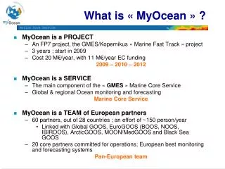
MyOcean is a SERVICE The main component of the « GMES » Marine Core Service Global & Regional Ocean monitoring and forecasting Information based on Analyses and Forecasts Currents, Temperature, Salinity, Sea level, Ice, …. Marine Core Service MyOcean is a TEAM of European partners 61 partners out of 29 countries ; ~350 people involved ; ~150 FTE 20 core partners committed for operations; european best monitoring and forecasting systems Pan-European team MyOcean is a PROJECT An EC/FP7 project, the GMES « Marine Fast Track » project 3 years ; has started on 1st April 2009, will end 31 March 2012 Budget 18 M€/year, with 11 M€/year EC funding 2009 – 2010 – 2011 – 2012 MyOcean: a service, a team, a project
MyOcean service reponsibility Provider MyOcean Marine Core Service Provider END - USERS OBSERVATIONS Provider The downstream cut-off The upstream cut-off downstream to the service: ... is done (duty) by a specialized agency or a national center ; usually already in place Example : NATIONAL AND COASTAL SYSTEMS upstream to the service ... is done (duty) by an observation agency or center Example : Eumetsat SAF or Marine Res. Infrastr. MS facility Value added Observational and Model Data EuroARGO, EuroSites EMSO, EGO, etc
Market Segmentation- Areas of benefit • MyOcean will “provide the common denominator data for all users in the marine sector, in other words the information for existing & new downstream services.” Area 1 « MARINE SAFETY » (marine operations, oil spill combat, ship routing, defense, search & rescue, …) Area 3 « MARINE AND COASTAL ENVIRONMENT » (water quality, pollution, coastal activities, …) Area 4 « WEATHER, CLIMATE & SEASONAL FORECASTING » (climate monitoring, ice, seasonal forecasting, ..) Area 2 « MARINE RESOURCES » (fish stock management, ICES, FAO, …)
MyOcean targeted users • The Key Users • MyOcean will deliver a service to • EU: The European Union • Users: European agencies (EEA, EMSA, EDA, ...) • MS: The Member States • Users: National / Regional Service Providers (public or private) • IG: The Intergovernmental bodies • Users: MS and/or exec.bodies such as OSPAR, UNEP-MAP, HELCOM, ICES, ... EEA EMSA EDA ... Met Offices Ocean centers ... Env. agencies Research centers Navies, CoastGuards, .. OSPAR UNEP-MAP ICES ... CORE
The MyOcean service areas The Global Ocean + 6 European Seas Arctic GOOS BOOS NOOS GOOS Black Sea GOOS MedGOOS/MOON IBI-ROOS
5 TAC : Thematic Assembly Centers “Observations” 1 global and 6 regional MFC: Monitoring and Forecasting Centers “Model / Assimilation” Service Interface: Unique European entry Bulk delivery Help desk and expert support Web portal MyOcean System organisation 12 PRODUCTION UNITS TAC MFC Arctic Sea Level Baltic SST Atl. NWS Ice Global Service Interface Color Atl. IBI In Situ Med Sea Black Sea
MyOcean sub system components Upstream systems (external) Contributors (Product Managers and Service Managers) MyOcean Information System (MIS) Production Centres: Models (MFC) Production Centres: Observation(TAC) Service Desk Global Ocean Sea Level Arctic Ocean Ocean Color Web Portal Baltic Sea Sea Surface Temp. Atlantic NWS Atlantic IBI Sea Ice & Wind Mediterranean Sea In Situ Black Sea Users
MyOcean : Data flows between sub system components Service Management As-is formats Monitoring Contributors Production Centres: Observation(TAC) Production Centres: Models (MFC) Service Desk MyOcean Information System (MIS) Global Ocean Sea Level Web Portal Arctic Ocean Ocean Color Baltic Sea Sea Surface Temp. Atlantic NWS Atlantic IBI Sea Ice & Wind Interactions with MyOcean Mediterranean Sea In Situ Black Sea Information Management NetCDF / CF Views & maps Binary data products (datasets) NetCDF / CF Users
The MyOcean Service • Ocean Core Information • Temperature, Salinity, Currents, Color, Sea Level, Ice variables, Bio variables • Hindcast, NowCast, Forecast • Open Data Policy • Open access • Free access • One single desk • access point to the MyOcean pan-european information
MyOcean product portfolio • MyOcean is • “delivering regular and systematic reference information (processed data, elaborated products) on the state of the oceans and regional seas: • at the resolution required by intermediate users & downstream service providers, of known quality and accuracy, • for the global and European regional seas.” • Physical state of the ocean, and primary ecosystem • For global ocean, and main European basins and seas • Large and basin scale ; mesoscale physics • Hindcast, Nowcast, Forecast • Data, Assimilation and Models
A simple and single portfolio of products for the whole pan-European MyOcean marine core service A reference definition shared by users, producers and stakeholders, regularly updated Standard parameters MyOcean Catalogue is available
http://www.myocean.eu.org A preliminary service in place: http://www.myocean.eu Improvement line: Version0 now ; Version1 end of 2010; Version2 end of project
MyOcean Service Statistics • Service Requests to end February.
MyOcean Service Statistics • User types to end February
MyOcean Service Statistics • Data Use
MyOcean Service Statistics • Products requested to end February. n
MyOcean Service Statistics • MFC product requests to end February. u
MyOcean Service Statistics • TAC product requests to end February.
In synthesis • MyOcean is a component of a so-called ‘cyber-infrastructure’, it is the part which makes available advanced and highly integrated information about the past and future ocean state • It builds upon the ‘existence’ of a data collection network and an upstream data flow, not yet fully coordinated and harmonised • It is a highly developed sector of marine sciences, driven initially by science and technology and now by ‘users’ • Lesson learned: science based engineering approach to be undertaken as soon as possible in the development of the future components
Gaps and needs • Need for a stable and well designed interface with the data collection initiatives – e.g. ESFRI marine projects, EMODNET, etc • The upstream data collection initiatives should have a totally free and open access data policy, no resilience time • Need for a capacity building/training initiative to disseminate required technology and knowledge to develop and use the MyOcean products • Start the transition from technology to a user driven infrastructure
Final considerations: what is needed for a ‘new’ marine research infrastructure initiative • A comprehensive marine monitoring and forecasting "cyberinfrastructure” • This should contain: • data acquisition - now partially done by ESFRI initiatives plus EuroSites, etc. BIG GAP • data storage, data management – now partially done by SeaDataNet, GMES-ESA space data initiative, GMES-EEA in situ data initiative, EUMETSAT SAFs, EMODNET, Digital Repositories initiatives • data integration, data mining – done by MyOcean (real time), SeaDataNet (historical) • data visualization and transformation – done by MyOcean (real time), SeaDataNet (historical)
Final considerations, cont. • A comprehensive marine monitoring and forecasting "cyberinfrastructure” • This should contain: • A framework to start new comprehensive, multi-purposes ocean observatories, DATA COLLECTION! • It should enhance the European competitiveness on innovative ocean technology considering multidisciplinarity at its heart • Should be connected as much as possible to European GRID initiatives (Backbone high speed hardware and middleware) • It should maintain the two stream flow of information: real time and historical, delayed mode
The multi-purpose offshore marineobservatories: need for a strategy plan + Planning of the ocean territory in accordance with Natura 2000, MFSD, WFD