Outline
National Weather Service North Central River Forecast Center Mississippi River Forecast Procedure. Outline. Overview of NCRFC Collaboration with other agencies Forecast Timelines Recent modeling changes Future collaboration. Area of Responsibility. Forecast Point Locations.

Outline
E N D
Presentation Transcript
National Weather ServiceNorth Central River Forecast Center Mississippi River Forecast Procedure
Outline Overview of NCRFC Collaboration with other agencies Forecast Timelines Recent modeling changes Future collaboration
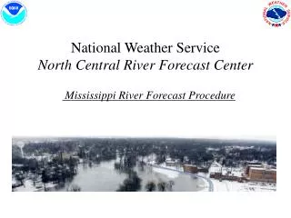
Area of Responsibility Forecast Point Locations Hudson Bay Drainage Great Lakes Drainage • 411Forecast Points Major drainages • Hudson Bay • Mississippi • Great Lakes Mississippi R. Drainage
Forecast Services and Products Short Term Forecasts and Guidance • Daily Stage Forecasts: 81 daily forecast locations • Daily Flow Forecasts: Routinely sent to Corps of Engineers (at least 4 times per day) • Flood Event Based Forecasts: 411 flood forecast points • Long Range Forecasts: MIS Forecast on Wednesday for Hannibal and St. Louis (Mississippi navigation) • 138 Flash Flood Basin Forecast Locations • 461 County Flash Flood Guidance • Daily Zero QPF MIS (St. Louis) Forecast (Mississippi navigation) • QPF Ensemble Forecasts for all forecast points Long Term Probabilistic Products • ~ 400forecast points
Methods of Coordination and Data Exchange • Daily phone calls • Daily E-mails of flows and measurements • RI COE rivergages.com web page of forecast comparisons and rating shifts • Conference calls • LDM • Text messages with alarms • nwschat with St.Paul Corps of Engineers, USGS, DNR • NCRFC internal web page consolidates LDM data and text messages from the COE, RFC’s and USGS.
Morning Mississippi River Forecasting Timeline • 7:00 AM Automated flows sent to Corps of Engineers • 8:00-8:30 Receive MBRFC Missouri flow, run NCRFC model, send QC’dflows to LMRFC & Corps of Engineers. Coordinate. • 9:30-10:00 Compare MBRFC Missouri Flow vs. NWD RCC Flow. Receive the RI COE UNET data for initial model comparison. Coordinate. • 9:30-10:30 NCRFC internal coordination with Illinois, Upper Mississippi and tributary forecasters. Address potential issues that could generate large discrepancies with the NCRFC forecast and the St. Louis COE forecast such as QPF, Missouri flow, RI COE differences, etc. Coordinate. • 8:00-10:30 All forecasts sent. Deadline for RVFMIS is 10:30am. Send LMRFC & Corps of Engineers final Mississippi River flow forecast. • 9:00-11:30 Receive RI COE L & D 11 to 22 stage/flows and RI and St. Louis COE reservoir instructions. Coordinate. • 11:00-1:00 Send Zero QPF Navigation forecast for St. Louis. • 11:00-2:00 St. Louis COE sends internal St. Louis forecast and contributing flows. • 1:30-2:30 If text alarm or phone call received indicating large discrepancies in NCRFC and St. Louis forecast then an afternoon NCRFC forecast update may be necessary.
Evening MIS Forecasting Timeline • Deadline is10:00pm Probabilistic MIS Forecasting Timeline • Issued once per month • Historical years 1948 - 2008 • 90 day forecast • 4th Friday of the month • Mississippi River to LD 25 (Winfield)
Recent modeling changes on Mississippi River • Slower routing for Missouri Tributaries to Hannibal when Missouri tribs > 10k cfs • Option to route Illinois River flows to Grafton using the hydrologic vs. hydraulic model • Added plots in forecast model for our forecast stages vs. St. Louis Corps of Engineers forecast stages at St. Louis and Chester • Ability for forecasters to view regulation bands at Louisiana and Grafton in software which generates RVFMIS product
NCRFC automatically posts the QC’d Hermann flows • Preliminary QC’d Drop • Final Drop NCRFC does not post Hermann flows unless they have been QC’d
Future collaboration • 24 hour QPF is not routinely used with all partners so we should focus on the zero QPF forecast at St. Louis since we are all using the same inputs • nwschat
Guidelines for QPF Selection • When stages at St Louis are +5.0 and falling and there are no high water navigation restrictions in MVR, always use the “0” QPF tributary forecasts for both the Illinois and Mississippi Rivers MBMS models. • During periods when the stage at St. Louis is between +5.0 and 19.0 feet use the “0” QPF forecast unless the precipitation probability exceeds 60% or rain is already falling as displayed on radar, then use 24-hour QPF. • When stages are above 19 feet at St. Louis and rising or steady, use the 24 hour QPF. • If any high water restrictions are in place within MVR, use the 24-hour QPF. • Reservoir forecasts should continue to use the 24-hour QPF unless drought conditions exist, then use the “0” QPF. • During floods and highwater in MVR, always use the 24-hour QPF and possibly consider using the 72 hour QPF if conditions are critical and rain is likely for more than one day. • Forecasted snowmelt runoff should not be included in the forecast more than 24-hours before runoff is expected to occur except for case where MVR is experiencing high water. Typically, NWS factors it into their tributary forecasts several days ahead. However, we have the ability to graphically edit it out.