Download
1 / 35
350 likes | 369 Views
This presentation provides an overview of the IDM plan development, DHS responsibilities, IDM plan implementation, central data repository requirements, and the baseline and go-to architectures for interference detection and mitigation in positioning, navigation, and timing (PNT) systems.

E N D
Evaluation of Requirements for the Interference Detection & Mitigation (IDM) of Positioning Navigation & Timing (PNT) Interference Reports & Central Data RepositoryThe Institute of Navigation International Technical Meeting 2009 John Merrill DHS/MGMT/CIO/OAT Geospatial Management Office
Presentation Overview • IDM Plan Development & Overview • DHS IDM Responsibilities • IDM Plan Implementation • Central Data Repository Requirements • Baseline & Go-To Architectures • Systems under review • FAA Spectrum Engineering Tracking System (SETS) • Integrated Common Analytical Viewer (iCAV)
DHS IDM Plan Development • December 2004 - DHS assigned responsibility for domestic Space-based PNT IDM planning and coordination • June 2005 – DHS began Space-Based PNT IDM Plan development starting with existing processes in place for GPS outage reporting, tracking and resolution • June 2006 – Space-Based PNT IDM Plan coordinated with the U. S. PNT Executive Committee • August 2007 – Space-Based PNT IDM Plan approved/signed by the U. S. President
DHS IDM Responsibilities • Coordinate domestic capabilities to identify, analyze, locate, attribute, and mitigate sources of interference to the GPS and its augmentations • Develop and maintain capabilities, procedures and techniques, and routinely exercise civil contingency responses to ensure continuity of operations in the event that access to GPS signal is disrupted or denied. • Collect, analyze, store, and disseminate interference reports from all sources to enable appropriate investigation, notification and enforcement action
DHS IDM Plan Outline • Key Policies, Departments and Agencies • Departments and Agencies that were assigned responsibilities that impact PNT services • GPS Interference • GPS and the Critical Infrastructure • GPS Vulnerabilities and Analysis Studies • Categories of Jamming • Current GPS Interference Reporting Procedures • Space-Based PNT Interference Detection & Mitigation Plan
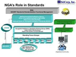
DHS IDM Plan Implementation • DHS Geospatial PNT Executive Committee • PNT Work Group • Geospatial Work Group • DHS Departments and U.S. Agencies with Geospatial and PNT responsibilities are represented • DHS IDM Implementation Plan • Development and maintenance is responsibility of DHS PNT Work Group • Standardized reporting format of interference reports • Continuous evaluation of operational procedures • Development of central data repository requirements
Central Data Repository Requirements Elicitation • Mission Needs Statement • Concept of Operations • USCG NAVCEN: All civil non-aviation users of GPS • FAA NOCC: All aviation users of GPS in the National Airspace • GPSOC: Status of GPS Service, including accuracy & availability; predictive coverage/accuracy information… etc… • Collective Effort of Departments of Transportation, Defense, and Homeland Security
Central Data Repository Requirements • Central Interference Report (IR) database focal point of all PNT interference • Encompass process and functions for detection validation, investigation, assessment, corroboration of IR • Automated dissemination of data and reduce IR information distribution delays for decision support • Mechanisms for cataloging PNT applications and associated vulnerabilities to interference • Employ information assurance components and processes to protect database • Assure the integrity of IR and sensors
Central Data Repository Requirements • User Access Threshold – 70 concurrent user access • User Access Sign-on – 475 read access • Submission of 150 PNT incident reports (IR) per month (1800 annually) • Database support 500,000 unique IR entries • Responses to system queries less than 8 seconds • New & updated IRs posted immediately visible, available and accessible • System availability of 99.9% • RSS for automatic update to subscribers – Initially: • Navigation Center, FAA Operations Center, GPS Operations Center.
Central Data Repository • Baseline Requirements - Cost control, use existing architecture • FAA Spectrum Engineering Tracking System (SETS) • Integrated Common Analytical Viewer (iCAV) • Geospatial enabling/visualization tool • Standard thin-client Geographic Information System interface that integrates multiple geospatial data sources from a centralized geospatial data warehouse • Based on the Environmental Systems Research Institute’s suite of products; ability to map, analyze, and view information from a mission specific application which assembles and compares data from various sources.
Current Architecture Navigation Center, FAA Operations Center, & GPS Operations Center only
Go-To Architecture Navigation Center, FAA Operations Center, & GPS Operations Center only
Central Data Repository • Federal Aviation Administration’s SETS core 10 data fields (mandatory entries): • SETS ID # {Record URL} • DATE START - DD/MM/YYYY • DATE STOP - DD/MM/YYYY • EVENT TIME START - #### UTC • EVENT TIME STOP - #### UTC • LATITUDE - +##.####### Degrees • LONGITUDE - +###.####### Degrees • USER EQUIPMENT TYPE • FREQUENCY (L1, L2, L5) - ####.#### • REMARKS & OTHER RELEVENT INFORMATION
Central Data Repository • Federal Aviation Administration’s SETS four additional data fields (optional entries): • Event Status • Source • Joint Spectrum Interference Report (JSIR) DTG • Altitude • Possible future data fields for consideration • US National Grid • The following slides show the existing FAA’s SETS web pages which will be changed to a DHS PNTIP “look and feel”
Address will change to: http://pnt.dhs.gov/login/EVENT_entryPNTIP.asp This is the Intranet web form available to authenticated users with access to the http://sets.faa.gov URL.
The PNTIP community can search for an event based on any one or combination of the searchable fields in the form (14 fields).
Once a field or set of fields is selected the user can then choose from one of four search criteria – All, Active, Open or Closed Tickets.
Name – This is the name of the POC most familiar with the issue. It is determined by the SETS authenticated user creating the ticket who is the best fit for a POC as it relates to the problem.
Event Start/End – This is the date and time the actual incident started. May be prior to when the TIX Opened date and time show.
Ident – This is a three or four letter identification that is unique to each facility.
Equip –FAA Equipment types which may be experiencing the interference. Eventually populate with PNT equipment
Event Type – This is the major category of events in SETS. In the GPS SETS module they are TESTING, ANOMALY, RFI, MILITARY and OTHER
Code – This is the FAA Maintenance Management System Mainframe event code category. In the GPS SETS module is replaced by JSIR.
Freq – This is the frequency of the affected NAS Radio Frequency service. For GPS events there are only three frequencies (L1, L2, L5)
Source – This is one of 14 major industry categories where the interference source will fit under. It includes Unknown and Other.
iCAV “Classic” First generation DHS Enterprise Geospatial tool with light analytical capability Built on National Geospatial-Intelligence Agency’s (NGA) Palenterra tool Provides access to HSIP and Web-mapping services for dynamic, real-time data feeds iCAV Next Gen Builds on the success of iCAV Classic by: Improving user interface Making data easier to find and use Enhancing analytical capabilities based on needs expressed by users Scheduled for deployment in early 2009 iCAV Classic and iCAV NextGen
Summary • Identification of central data repository requirements complete • The FAA SETS GUI will reflect PNT preferences • DHS will continue to evaluate iCAV as the lead geospatial analysis tool • Continue prototype evaluation & transition to operational test early 2009 • Establish central repository 2009 with TRIAD and slowly migrate other federal agencies for use • Eventually include international incident reports
Points of Contact DHS Geospatial Management Office Mr. John Merrill John.Merrill@dhs.gov FAA Spectrum Engineering Mr. James Aviles James.Aviles@faa.gov