Download
1 / 19
190 likes | 357 Views
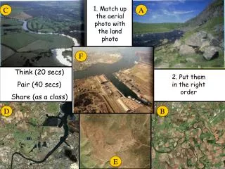
1. Match up the aerial photo with the land photo. C. A. F. Think (20 secs) Pair (40 secs) Share (as a class). 2. Put them in the right order. D. B. E. Upper? Middle? Lower?. Upper? Middle? Lower?. Upper? Middle? Lower?. Upper? Middle? Lower?.

E N D
1. Match up the aerial photo with the land photo C A F Think (20 secs) Pair (40 secs) Share (as a class) 2. Put them in the right order D B E
What landforms and features are found in the upper course of a river? • LO: • To describe and explain the formation of v-shaped valleys and waterfalls.
Learning Outcomes • Students MUST be able to describe the landforms in the upper course of a river. • Students SHOULD be able to describe and explain how landforms are created in the upper course of the river. • Students COULD apply their learning to the case study of the River Tees.
Let’s create a case study page! You will need ONE double page of your exercise book, a pen, ruler and pen!
The upper course of the River Tees Characteristics of the river in the upper course Add notes from the previous lesson to describe what the river is like in the upper section. • V-Shaped Valleys and Interlocking Spurs • Describe and explain how these features form. Use diagrams. • Page 10 of the OCR book • Page 68 of the A3 sheet • Waterfalls and Gorges • Describe and explain how these features form. Use diagrams. • Page 10-11 of the OCR Book • Page 69 of the A3 sheet http://www.youtube.com/watch?v=Ny441MkGan8
The River Tees • Cheeky facts and stats! • The highest point in the Pennines moorland is 893m above sea level. • The area receives over 2000mm of rain. • Near the beginning … • The source of the River Tees is Cross Fell in the Pennines. • There is lots of saturated peat bog at the source, which drains out of the bog creating small streams. • Rivers in their upper course have some typical features: • V-shaped valley • Interlocking spurs • Waterfalls http://www.youtube.com/watch?v=Ny441MkGan8 10 mins
V-Shaped Valley How does a v-shaped valley form?1. Vertical erosion (in the form of abrasion, hydraulic action and solution) in the river channel results in the formation of a steep sided valley.2. Over time the sides of this valley are weakened by weathering processes and continued vertical erosion at the base of the valley.3. Gradually mass movement of materials occurs down the valley sides, gradually creating the distinctive v-shape.4. This material is then gradually transported away by the river when there is enough energy to do so.
How do they form? As the river flows through the valley it is forced to swing from side to side around more resistant rock outcrops (spurs). As there is little energy for lateral erosion, the river continues to cut down vertically flowing between spurs of higher land creating interlocking spurs. Animation
How does a waterfall form? Rearrange the stages of formation into the correct order:


![[Secs 16.1 Dunlap]](https://cdn3.slideserve.com/6906224/secs-16-1-dunlap-dt.jpg)