Download
1 / 56
610 likes | 779 Views
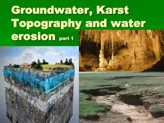
Dive into the world of groundwater and karst topography to discover how water erosion shapes the Earth's surface. Learn about aquifers, wells, springs, caves, sinkholes, and water erosion processes like stream erosion and transportation. Understand the importance of groundwater pollution awareness and management in this educational guide.

E N D
Groundwater • Soil is made up of many small rock and mineral fragments as well as organic material. • Holes, cracks, and crevices exist in the rock underlying the soil. • Water that soaks into the ground and collects in these pores and empty spacesbecome part of groundwater.
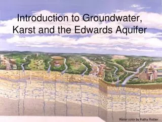
Groundwater keeps going deeper into the Earth’s crust until it reaches a layer of impermeable rock. • At this point, the water stops moving down. • Water begins filling up the pores in the rocks above. The layer of permeable rock that lets water move freely is an aquifer.
zone of aeration is the first layer of soil that is permeable. Water and air pass through this layer easily. • zone of saturation - The area where all of the rocks are filled with water is called the. • water table - the upper surface of this zone of saturation.
Groundwater pollution • Some of the sources of groundwater pollution include: • Sewage • Pesticides • Industrial chemicals • Mine site waste • Animal feedlot waste
Wells • People get the majority of their water from wells. A good well extends deep into the zone of saturation, where groundwater flows into the well and a pump brings it to the surface. • If too much water is pumped out, then wells can go dry.
What does a normal household well look like? • Water flows into a well and then a pump brings the water to the surface. • Wells can go dry if too many are located in one area, or if a drought takes place.
ARTESIAN WELL • Well in which groundwater rises on its own under pressure.
A SPRING - is a place in the water table where water is so close to Earth’s surface that water flows out naturally. • Springs form where the water table intersects the ground surface. • Springs are found on hillsides or other places where the water table meets a sloping surface.
Karst Cavern • Groundwater mixes with carbon dioxide to form carbonic acid. • Limestone is a rock that is easily dissolved by carbonic acid. • As the acidic groundwater moves through pores in limestone, the rock dissolves, enlarging cracks until an underground opening called a cave is formed.
Groundwater not only dissolves limestone to make caves, but it also can make deposits on the insides of caves. • Stalactites- mineral deposits (similar to icicles) that form from water dripping from cave walls containing calcium ions dissolved from limestone. • Stalagmite - If the water evaporates while hanging from the ceiling, the calcium carbonate is left behind and builds upward.
Sinkhole • If underground rock is dissolved near the surface a sinkhole may form. • A sinkhole is a depression on the surface of the ground that forms when the roof of a cave collapses, or when rock near the surface dissolves. • These are common in areas that have a lot of limestone and enough rain water to keep the groundwater system supplied with water.
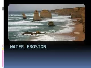
Water erosion Part 2
1. Running Water 2. Energy 3. The water cycle Most effective agent in wearing down the surface of the earth From the sun… Powers the running water. energized by the sun and circulates all of the earths life giving water. An unending circulation of Earth’s water supply A. Stream Erosion
4. Bedrock Breakup Occurs in 2 ways. Mechanical means– Using sand, gravel and small rocks the water grinds at the bedrock. Boulders are also used as cutting tools. This grinding action is called Abrasion.
5. Transportation Rivers ability to move material: a. Solution– dissolved materials from bedrock. (25% of stream) b. Suspension– includes clay, silt, and fine sand. Although these materials are heavier than water they are stirred up and kept from settling on the bottom by the water moving. (50% of stream) c. Bed load– Sediment moved along the stream bottom. (25% of stream). Ex large cobbles and boulders.
6. Carrying Power 7. Discharge Is indicated by amount of sediment and the particle size being moved. depends upon the speed of the stream and its discharge. Is the volume of water flowing past a given point in the stream at a given time. Increases from the source to the mouth Expressed in CFS (Cubic feet per second)
B. Parts of a Stream • Channel: the course the water in the stream follows
1. Flood Plain When a river swells and floods and covers part of the valley floor. Forms when the stream cuts mainly side to side. Limiting development allows floodplain to absorb floodwaters with little harm to structures
Flood control Dams flood walls and levees: (man-made) keep water in main channel and control flooding. Downsides: Must completely surrounded inhabited area, also expensive
Flood control Flood control dams: store water in reservoirs and release it gradually • Can impact main stream or lots of small tributaries • Expensive • Flood large areas • Block fish migrations
2. Waterfalls River may flow over hard rock onto softer rock. Creates quick drops
3. Meanders A series of broad curves in the stream bed. Form when water moves slowly across a wide flood zone. Also forms oxbow lakes- U shaped cut off of the stream
Cut bank erosion Point bar deposits } Meander loop
4. River valleys V-shaped: cutting into floor & walls and are worn away. Steep valleys create canyons
5. Expensive Can erode its channel
Why streams & rivers deposit sediment. 1. Low slope 2. Bed widens 3. Meets obstruction 4. Reaches a lake or sea C. River Deposition
Answer: Loss of both discharge and speed This is a photo of a car buried in flood sediments. Question : Why does a river leave so much sediment on its valley floor after a flood?
2. Delta- fan shaped deposit where a stream enters a lake or ocean
3. Alluvial Fans- sloping deposits where a mountain stream reaches land.