Download
1 / 30
300 likes | 329 Views
Distribution of Nitrate in Ground Water Under Three Unsewered Subdivisions. Erin P. Eid Mike Trojan Jim Stockinger Jennifer Maloney Minnesota Pollution Control Agency Ground Water Monitoring and Assessment Program. Why conduct a Septic System study?.

E N D
Distribution of Nitrate in Ground Water Under Three Unsewered Subdivisions Erin P. Eid Mike Trojan Jim Stockinger Jennifer Maloney Minnesota Pollution Control Agency Ground Water Monitoring and Assessment Program
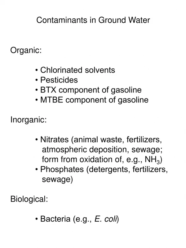
Why conduct a Septic System study? • Assess water quality in unsewered areas • Few studies comparing water quality between different unsewered subdivisions • Limited information of spatial distribution of nitrate in unsewered subdivisions • Determine risk to ground water and surface water • Limited information for water and city planners
OUTLINE • Study Design • Results • Conclusions • Future Studies
STUDY DESIGN • Objectives • Variables • Sampling Design • Study Area • Parameters
Objectives • Determine the spatial distribution of nitrate in ground water under three unsewered subdivisions • Identify factors affecting the distribution of nitrate under the three subdivisions
Variables • Density and age of septic system and subdivision • Aquifer hydrogeology and geochemistry • Performance of septic system • Depth to ground water
Sampling Design • One-time sampling events using shallow geoprobe and deeper domestic well samples • Collection of soils for textural analysis
Geoprobe and Domestic Well Cross-SectionCross-section showing geoprobe (G) and domestic well (W) sampling locations through an aquifer
Site Criteria • Sandy Soils • Sand and Gravel Aquifer • Less than one acre lot size • Aquifers vulnerable to contamination • Results applicable to other areas • Local cooperation
Site Locations • Baxter Area • sampled 37 domestic wells • geoprobed 24 sites • St. Joseph Area • sampled 23 domestic wells • geoprobed 7 sites • Lakeland Area • sampled 44 domestic wells • geoprobed 9 sites
Study Area - Baxter • Urban Area of 40,000 people • Considerable land use changes last 10 years • Surficial geology consists of outwash deposits of sand and gravelly sand • Shallow sand and gravel aquifer with 15 feet of land surface
4 9 I # S # S # S # S # S # S # Y # S # S # Y # S # S # Y # S # S R # S # S E # S # S # Y # S # S V I # S l R i D o m e s t i c W e l l # S S # a r T X Y # G e o p r o b e x I # Y i # S O o r R C . C t S . T S # S # Y # S # Y # S # S # # # # # # # S S S S S S S Study Area - Lakeland • Community of approximately 5,000 people • Has not experienced significant growth in last 10 years • Surficial geology consists of coarse sand, gravel, and gravelly sand terrace deposits • Depth of bedrock varies between 0 and 60 feet • Unconfined sand and gravel aquifer found at 45 to 80 feet below land surface
Study Area - Pleasant Acres • Located near metropolitan area of 100,000 people • Considerable land use changes within last 10 years • Surficial geology consists of primarily outwash deposits of sand and gravelly sand • Surficial sand and gravel aquifer located between 10 and 25 feet of land surface
Parameters • Field measurements: • oxidation-reduction potential, temperature, pH, specific conductance, dissolved oxygen, and water level • Laboratory Analysis: • Major cations and anions • dissolved organic carbon • ammonia- and Kjeldahl-nitrogen
Nitrate concentrations at the water table did not differ between the three areas
Lakeland: Nitrate concentrations did not decrease with depth
Lakeland Cross-section Sand and Gravel Clay ? Bedrock ?
Baxter: Nitrate concentrations decreased rapidly in the upper 20 feet of the surficial aquifer
Pleasant Acres: Nitrate concentrations decreased abruptly at about 25 feet
Pleasant Acres Cross-section Sand Clay Sand ?Bedrock ?
The depth to which each aquifer is vulnerable to nitrate contamination varied between the three areas
Possible reasons for the differences with depth? • Lower rates of denitrification in Lakeland • Fractured bedrock flow in Lakeland • Higher aquifer hydraulic conductivity in Baxter may move nitrate more deeply than in Pleasant Acres • Pleasant Acres has well-defined geochemical zones • Differences in effluent discharge
12 to 25 percent of samples collected at the water table exceeded the MCL of 10 ppm
Lakeland < 2 ppm 2 - 5 ppm 5 - 10 ppm > 10 ppm
< 2 ppm # # 2 - 5 ppm # # # # 5 - 10 ppm # # # # > 10 ppm # # Pleasant Acres
< 2 ppm 2 - 5 ppm 5 - 10 ppm > 10 ppm Baxter
Conclusions • Nitrate concentrations at the water table under unsewered developments are about 4 to 6 ppm • The depth of nitrate impacts from septic systems is controlled by aquifer geochemistry and hydrology • In unsewered areas small lot size and the age of the development are factors in elevated nitrate levels
Future Studies / Use of Data • Septic System studies in additional communities • Effects of septic systems on sensitive surface water • Relationship between septic systems, lot size, and age of development • Computer simulations for prediction of effects of septic systems on ground water quality in other communities
http://www.pca.state.mn.us/water/ groundwater/gwmap