Download
1 / 21
210 likes | 407 Views
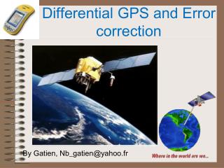
GPS Differential Correction We can improve this by using two units in what is called differential positioning. Station set up over known position (Base). GPS Differential Correction We can improve this by using two units in what is called differential positioning.

E N D
GPS • Differential Correction • We can improve this by using two units in what is called • differential positioning. • Station set up over known position (Base).
GPS • Differential Correction • We can improve this by using two units in what is called • differential positioning. • Station set up over known position (Base). • Station set up at unknown point.
GPS • Differential Correction • We can improve this by using two units in what is called • differential positioning. • Station set up over known position (Base). • Station set up at unknown point. • Collect data simultaneously. (from the same satellites) • (Since S/A, satellite clock effects, and part of ionospheric effects are likely to be similar (or the same) for each point, these errors will be approximately the same for each point. Thus when we subtract one point coordinates from another these errors cancel out.Thus we get the difference between the points with higher accuracy.) • Calculate new points from known Base Station and difference.
Differential Positioning to Improve Accuracy:
Problem: Slightly reduced accuracy relative to post-processed dif. - about 10-30%
GPS Real-time differential correction Slightly lower accuracy (5m or less using C/A code receivers; often 2m) Better location while in the field Requires a radio link (typically FM) Requires base station: can use CORS or US Coast Guard GPS radio beacons (if in range of their standardized correction signal)
Another Problem with Real-time Differential: Somebody has to Run the 2nd Station Options: 1) Your own 2) Beacon Receiver 3) Satellite subscription service 4) WAAS (partial correction)
Beacon Receiver - Most Common Choice for Natural Resource GIS CORS – Continuous Operation Reference Station
WAAS – Wide Area Augmentation System -Network correction broadcast to geo-stat. sat. -Best for unobstructed observation -3 meter accuracy predicted
GPS WAAS Wide Area Augmentation System (WAAS), is developed and administered by the U.S. F.A.A. for provide accurate, dependable aircraft navigation. Real-time accurate fixes within 7m or less. Network of ground reference stations(scattered about North America)
GPS WAAS Signals from GPS satellites are received at each station and errors calculated, (as with differential GPS). A generalized correction is calculated based on location transmitted to a geo-stationary satellite. The correction signal is broadcast to a WAAS compatible receiver
Today’s Choices: Cost vs. Accuracy and Attribute Handling Moderate accuracy (errors 10 meters) few lines, areas, or attributes, use a recreational receiver ($300, e.g., Garmin, Magellan) Higher accuracy (errors < 5 meters) few lines, areas, or attributes, rec-based differential receiver is best ($1000, e.g., Navtech) High accuracies and high-volume GIS use a GIS-capable differential package ($5,000 – 10,000, e.g., Trimble, CMT)
Adding Attributes to GPS Data
You often wish to collect substantial attribute data specific items, specific types
Customize the set of features available
Pick lists - speeds entry, reduces errors
Customize Data Entry with a Data Dictionary