Download
1 / 40
400 likes | 578 Views
Scenarios from Regional Climate Models: More Uncertainty or Better Information (or Both)? Linda O. Mearns National Center for Atmospheric Research. ASP Summer Colloquium Uncertainty in Change Research: An Integrated Approach NCAR, Boulder, CO July 25, 2014.

E N D
Scenarios from Regional Climate Models: More Uncertainty or Better Information (or Both)? Linda O. Mearns National Center for Atmospheric Research ASP Summer Colloquium Uncertainty in Change Research: An Integrated Approach NCAR, Boulder, CO July 25, 2014
Uncertainties about Future Climate • The future trajectory of emissions of greenhouse gases (based on uncertainties about how the world will develop economically, socially, politically, technologically) • Explored through the development of scenarios of future world development (Webster presentation) • How the climate system responds to increasing greenhouse gases(Forest, Sanderson presentations) • Explored through use of climate models • Spatial scale at which climate models are run is an additional source of uncertainty • The natural internal variability of the climate system (Deser presentation)
What about higher resolution model information about climate change? • Global models run at about 100 - 150 km (60-80 mile) spatial resolution - what resolution do we need for adaptation purposes? • How to balance the desire for higher resolution with the other major uncertainties (future emissions, general response of climate system, internal variability).
Uncertainty due to Spatial Scale of Regional Climate Simulations Dynamical Downscaling
Global Climate Models Regional Climate Models
NAS, 2012 Advancing Climate Modeling
Objectives of Downscaling • Bridge mismatch of spatial scale between that of global climate models and the resolution needed for impacts and adaptation assessments (statistical or dynamical downscaling) • Resolve high resolution processes that are responsible for regional climate Different objectives may require different types of downscaling
But, once we have more regional detail, what difference does it make in any given impacts/adaptation assessment? What is the added value? Do we have more confidence in the more detailed results?
What high resolution climate modelingis really useful for It provides insights on realistic climate response to high resolution forcing (e.g. mountains, coasts)
Regional Modeling Strategy Nested regional modeling technique • Global model provides: • initial conditions – soil moisture, sea surface temperatures, sea ice • lateral meteorological conditions (temperature, pressure, humidity) every 6-8 hours. • Large scale response to forcing (100s kms) • Regional model provides finer scale (10s km) response
Advantages of higher resolution North America at typical global climate model resolution Hadley Centre AOGCM (HadCM3), 2.5˚ (lat) x 3.75˚ (lon), ~ 280 km North America at 50 km grid spacing
Uncertainties Contributed by Regional Climate Models • Not just the resolution, but often are different models (physics, dynamics, parameterizations of GCM are not the same as RCM) • Size and location of the domain of interest • Effect of the quality of lateral boundary conditions (e.g., from GCM) • Also different realizations will produce different climate simulations (i.e., using different realizations of GCM)
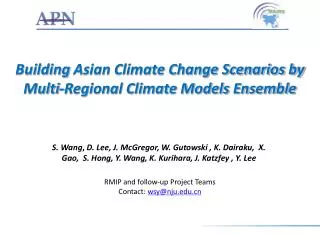
The North American Regional Climate Change Assessment Program (NARCCAP) • Explores multiple uncertainties in regional • and global climate model projections • 4 global climate models x 6 regional climate models • Develops multiple high resolution (50 km) • regional climate scenarios for use in impacts • and adaptation assessments • Evaluates regional model performance to establish • credibility of individual simulations for the future • Participants: Iowa State, PNNL, LLNL, UC Santa Cruz, Scripps, Ouranos (Canada), UK Hadley Centre, NCAR • Initiated in 2006, funded by NOAA-OGP, NSF, DOE, USEPA-ORD – 5-year program www.narccap.ucar.edu
NARCCAP PLAN – Phase II A2 Emissions Scenario GFDL CGCM3 HADCM3 CCSM3 CAM3 Time slice 50km GFDL Time slice 50 km Provide boundary conditions 2041-2070 future 1971-2000 current CRCM Quebec, Ouranos RegCM3 UC Santa Cruz HadRM3 Hadley Centre MM5 Iowa State ECPC RSM Scripps WRF PNNL
AOGCM-RCM Matrix AOGCMS RCMs
CCSM-driven change in summer temperature
17 GCMs used in AR4Change in Summer Precipitation Mearns et al. PNAS (submitted)
11 RCMs Change in Summer Precipitation Mearns et al. (2013)
Conclusions • The RCMs tend to intensify patterns of change in precipitation (i.e., greater decreases in summer; greater increases in winter) • RCMs are most dominant in summer in terms of producing information different from the global models. • But more process level studies are necessary to determine if RCM changes are more credible than those of GCMs
GCM ensemble member GCM ensemble member GCM GCM GCM RCM RCM RCM ensemble member RCM ensemble member RCM ensemble member Mother Of All Ensembles The Future scenario scenario scenario GCM ensemble member RCM R. Arritt
Coordinated Regional Downscaling Experiment (CORDEX) ~ Regions ~ ENSEMBLES NARCCAP RMIP CLARIS (C. Jones, 2009)
General Aims and Plans for CORDEX Provide a set of regional climate scenarios covering the period 1950-2100, for the majority of the populated land-regions of the globe. Make these data sets readily available and useable to the impact and adaptation communities. Provide a generalized framework for testing and applying regional climate models and downscaling techniques for both the recent past and future scenarios. Foster coordination between regional downscaling efforts around the world and encourage participation in the downscaling process of local scientists/organizations
CORDEX ECHAM5 HadCM3 A1B SRES scenario, precipitation trend to 2050 Paeth et al., 2011
Phenomena that Benefit from very High Resolution • Orographic precipitation • Convective storms - hourly rainfall characteristics (Kendon et al., 2014) • Diurnal cycle of convection • Urban and land-surface feedbacks (Cities Module, Aug 4)
Heavy Hourly Rainfall Events – 12 vs. 1.5 km resolution Summer bias change mm/hrKendon et al. 2014
‘We conclude that accurate representation of the local storm dynamics is essential for predicting future change in convective storms (along with accurate representation of changes in the larger-scale environment inherited from the driving GCM).’ • Kendon et al. 2014
WRF Simulations – So Cal Hall et al., 2012 Nests 18, 6, 2 kms
Annual Temperature Change Current = NARR 1981-2000 Future = RCP 8.5 CCSM4 2041-60 (NARR baseline perturbed with CC signal from CCSM4) Degrees F
And What of Added Value? • Do we agree on what it is? • reducing bias, reducing uncertainty, characterizing uncertainty, regional knowledge, co-development of scenarios or team approach? • Do we agree on how to demonstrate it? • Usually demonstrated through better validation at high resolution – may be necessary but not sufficient conditions • Hall et al. 2012 and Kendon et al. 2014 do demonstrate added value (but what does one do with it?)
Although different approaches to achieving high resolution in climate models have been explored for more than two decades, there remains a need for more systematic evaluation and comparison of the various downscaling methods, including how different grid refinement approaches interact with model resolution and physics parameterizations to influence the simulation of critical regional climate phenomena. NAS, 2012 (Advancing Climate Modeling)
Dueling Perspectives • ‘Adapting to climate change … will require accurate and reliable predictions of changes in regional weather systems, especially extremes.’ – Nature editorial, 2008 and Shukla et al., 2009 World Modeling Summit for Climate Prediction • ‘Effective and robust adaptation strategies are not significantly limited by lack of accurate and precise regional climate predictions.’ - Hulme and Dessai, 2008