Geological Oceanography
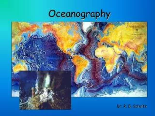
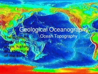
Geological Oceanography. The scientific study of the origin, history, and structure of the earth. Ocean Topography. Topography is a g raphic representation of the surface features of a place or region …in this case, the ocean basins. What do ocean basins look like?.

Geological Oceanography
E N D
Presentation Transcript
Geological Oceanography The scientific study of the origin, history, and structure of the earth Ocean Topography
Topography is a graphic representation of the surface features of a place or region …in this case, the ocean basins. What do ocean basins look like?
How do we know what it looks like? Soundings are made by sending a sound pulse into the water.
Echosounders are attached to the hull of a ship or a towed vehicle. • An echosounder sends a sound pulse into the water. The sound energy travels through the water to the ocean bottom where it is reflected back towards the source, received, and accurately measured.
Undersea structures shown by Sonar • This surprised oceanographers who expected the ocean bottoms to be smoother, more like a bowl (deepest in the middle and getting shallower towards continents).
Features found on the seafloor Continental shelf Continent Mid-ocean ridge Sea mount Depth (m) Central rift zone Abyssal plain Oceanic trench
Geological Oceanography Journal Question • http://videos.howstuffworks.com/science/sonar-videos-playlist.htm#video-30297 1. Describe how scientists find out what the ocean floor looks like?
The ocean basin: Structures • Continental Margin: Continental Shelf Continental Slope Continental Rise Submarine Canyons 2.Deep Ocean Basin: Abyssal Plains Oceanic ridges 3.Trenches 4.Seamounts and Guyots 5. Atolls
Submerged, outer edge of the continents. Found on the leading edge of the continent crashing into an oceanic plate. Two types: 1. Active Margin (Pacific) 2. Passive Margin (Atlantic) No collisions taking place, tectonic activity is minimal
Continental Shelf: Similar to the continent (compared to the deep ocean). They have hills, depressions, mineral and oil deposits. In Atlantic Canada, the continental shelf holds the best fishing areas.
Submarine Canyon: on the edge of the continental shelf • V-shaped indentations into the continental shelf, usually ending in a fan shaped wedge of sediments.
The Gully! • Submarine canyon off Nova Scotia • Marine protected area because of the rare corals found there • The natural gas pipeline goes right by it though! The Gully
This coral forms colonies up to two meters high and takes between 200 and 500 years to grow such a colony. They only grow 1.5 millimeters a year." Bubble Gum coral Largest reported from N.S. was 7m tall!
Deep Ocean Basin • Abyssal plains: From the Greek meaning “without bottom”. They are flat, cold, dark, featureless expanses of sediment-covered ocean floor. They are most common in the Atlantic. • Ocean Ridges: Mountainous chains of actively spreading ocean floor. They can rise 2km from the ocean floor and sometimes form islands such as Iceland, the Azores and Easter island.
Trenches • Deep gap in ocean floor, formed by movement of plates. • Example: Mariana Trench is 10,668 meters deep • They are among the most active areas on Earth. • They are the deepest areas of the Earth’s crust. • 90% of trenches are found around the Pacific rim.
Seamounts and Guyots Both are undersea volcanoes that originated at a hotspot or along a ridge Guyots once reached the surface of the ocean and have flat, eroded tops Seamounts never reached the surface, so they have pointy tops
Atolls • A ring shaped island of coral reefs and coral debris. These often form over sinking inactive volcanoes.
Ocean floor features: Trenches Sea mounts Mountain chains Fracture zones